Smaills Beach facts for kids
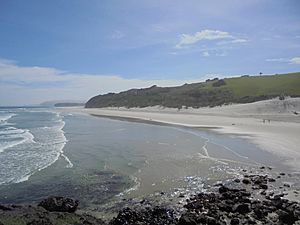
Smaills Beach (sometimes called "Smails Beach") is a beautiful beach on the Pacific Ocean. It's about 7.6 kilometers (4.7 miles) southeast of Dunedin, New Zealand. You can find it inside the Ocean Grove Reserve, right next to Tomahawk Beach. This is where the Otago Peninsula connects to the main part of the South Island.
Most of Smaills Beach has white sand, but the western end is covered in dark volcanic rocks. Just off the shore, there's a rocky island called Bird Island. It's named this because many seabirds like to hang out there! Bird Island changes how the waves break, making Smaills Beach a popular spot for surfers. This beach is also famous for its amazing wildlife.
Contents
Exploring Smaills Beach
Smaills Beach is about 800 meters (2,600 feet) long and faces mostly south. The far western part of the beach has lots of big rocks.
Beach Features
To the west, a small hill made of black volcanic rock called Tomahawk Bluff separates Smaills Beach from Tomahawk Beach. This bluff has cool sea caves, and at the top, you'll find the Jack Fox Lookout. When the tide is very low, you can walk around the base of the bluff, making Tomahawk and Smaills feel like one big beach!
To the east, Tomahawk Creek flows into the ocean, running along the bottom of tall cliffs called Māori Head. Beyond these cliffs are Pudney Cliff and Highcliff. North of the beach, you'll see sandy dunes covered in plants, leading up to Tomahawk Road.
Ocean Waves and Safety
The waves from the Pacific Ocean hit Bird Island, which makes them break in interesting ways. This is great for surfing! However, it's important to know about rip currents here. These are strong currents that can pull you out to sea, so always be careful.
You can get to Smaills Beach by walking paths that go through the dunes from the parking areas on Tomahawk Road. The main path is next to Tomahawk Creek.

Amazing Wildlife
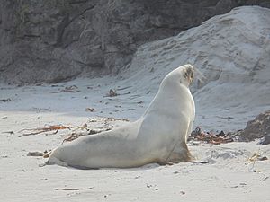
Smaills Beach is a special place for many animals. You might see yellow-eyed penguins, little blue penguins, and New Zealand sea lions here.
Protecting Animals
If you visit, please be careful and keep your distance from these animals. This helps keep them safe and keeps you safe too, especially around the sea lions. If you bring a dog, please keep it on a leash and under control. Sea lions can get aggressive if they feel threatened, which could lead to injuries for both the animal and your dog.
You'll also often see different kinds of birds on the beach, like oystercatchers, red-billed gulls, and black-backed gulls. The small creatures living in the sand and water at Smaills are similar to other nearby beaches, but there's a wider variety of places for them to live here.
Caring for the Dunes
The sand dunes at Smaills Beach can be worn away by the wind, which is a problem for the coast. The Dunedin City Council is working with the Tomahawk Smaills Beachcare Trust to fix this. They are shaping the dunes and planting new plants to help them stay strong.
History and Fun at the Beach
Smaills Beach has a cool history and is still a popular spot today.
Beach History and Name
Long ago, before Europeans arrived, Māori used Smaills and Tomahawk Beaches as part of a walking path. They traveled between Ōtākou and Tomahawk Lagoon.
Smaills Beach is named after the Smaill family. They were important farmers in the area in the 1870s and 1880s. Their old family home is still standing near the beach! It's now a special historic building and is used as the clubhouse for the Tautuku Fishing Club. In 1897, the area around both Smaills and Tomahawk Beaches became a government protected area. Then, in 1931, it was officially named the Ocean Grove Reserve.
What People Do Here Today
Smaills Beach is known as a great place for surfing, so lots of surfers come here. However, because of the strong rip currents, people sometimes need to be rescued. There are no lifeguards watching the beach, so it's very important not to surf or swim alone.
The Tomahawk Smaills Beachcare Trust has a special plant nursery at Smaills Beach. They grow about 4,000 plants every year! These plants are used to help the sand dunes grow strong and stable all around the Ocean Grove Reserve.
The parking areas on Tomahawk Road above the beach are also used by people who like freedom camping.
 | Toni Morrison |
 | Barack Obama |
 | Martin Luther King Jr. |
 | Ralph Bunche |


