Ocean Grove, New Zealand facts for kids
Quick facts for kids
Ocean Grove
|
|
|---|---|
|
Suburb
|
|

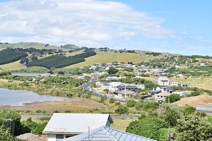
Ocean Grove sits close to the southern shore of Tomahawk Lagoon's two lobes- the Bottom Lagoon is visible at the lower left, and the Top Lagoon can be seen behind it.
|
|
| Country | New Zealand |
| Local authority | Dunedin |
| Area | |
| • Land | 64 ha (158 acre) |
| Population
(2018 Census)
|
|
| • Total | 441 |
|
|
||
Ocean Grove, also known as Tomahawk, is a suburb in the southeast of Dunedin, a city in New Zealand. It's a quiet, mostly residential area right on the Pacific Ocean coast. Ocean Grove is found at the southwestern end of the Otago Peninsula. It is about 6.5 kilometers (4 miles) southeast of Dunedin's city center.
This suburb feels a bit separate from the rest of the city. This is because of a high cliff called Lawyers Head and the Andersons Bay Cemetery to its west. Ocean Grove is very close to the Tomahawk Lagoon. This lagoon has two parts and is famous for its amazing bird life. The inner part of the lagoon is even a special wildlife reserve.
Contents
History and Name
The area was known as Tomahawk until the 1930s. The name "Tomahawk" was first written down in 1852. It probably doesn't mean the weapon. Instead, it's likely an English version of Māori words.
Meaning of "Tomahawk"
The name "Tomahawk" might come from toma haka. Toma means a place where bones are kept, or a special shrine. Haka is often thought of as the Māori dance of challenge. However, it could also be a Southern Māori way of saying hanga, which means to build or create. Ocean Grove became part of Dunedin City in 1968.
Exploring Ocean Grove
Ocean Grove has one main road called Tomahawk Road. This road runs mostly next to the coast. It connects to the suburbs of Andersons Bay and Tainui in the west. To the east, Tomahawk Road changes into Centre Road. This road goes up to the middle ridge of the Otago Peninsula. It then joins Highcliff Road, which runs along the ridge between Shiel Hill and Portobello.
Beaches and Lagoon
The Tomahawk Lagoon is separated from the sea by Tomahawk Beach when the tide is low. This beach stretches for about 1 kilometer (0.6 miles) to the east from the lagoon's mouth. Further east, you'll find a smaller beach called Smaills Beach. Beyond Smaills Beach is a rocky outcrop known as Maori Head. This headland is about 2 kilometers (1.2 miles) from the lagoon's mouth. Close to Maori Head, there's a rocky reef and a small place called Bird Island.
Local Landmarks
Ocean Grove has some interesting old structures. You can find the remains of two World War II gun emplacements here. These are close to the Jack Fox Lookout. This lookout is at the top of Tomahawk Bluff, a high point that separates Tomahawk Beach from Smaills Beach.
There's also a special two-story house called Glen Cairn at Smaills Beach. This was the original home of the Smaill family. Today, it's used as the main building for the Tautuku Fishing Club. Between Tomahawk Beach and Tomahawk Road, you'll find Tomahawk Domain. This is a recreation ground used for sports. It's also the home ground for the Grants Braes football club.
Population and People
Ocean Grove covers about 0.64 square kilometers (0.25 square miles). It is part of a larger area called Tainui.
In 2018, Ocean Grove had a population of 441 people. This was a small decrease from 2013, but an increase since 2006. There were 177 homes in the area. The population was almost evenly split between males and females. About 19.7% of the people were under 15 years old. Most people, about 55.8%, were between 30 and 64 years old.
Most residents, about 92.5%, were European/Pākehā. There were also people of Māori, Pacific, and Asian backgrounds. When asked about religion, many people, 57.8%, said they had no religion. About 29.3% were Christian.
Many adults in Ocean Grove had a university degree or higher. Most people aged 15 and older were employed, either full-time or part-time.
 | Emma Amos |
 | Edward Mitchell Bannister |
 | Larry D. Alexander |
 | Ernie Barnes |


