
Andersons Bay facts for kids
Quick facts for kids
Andersons Bay
|
|
|---|---|
|
Suburb
|
|

Causeway across the mouth of the Andersons Bay Inlet
|
|

Andersons Bay
Location in New Zealand
|
|
| Country | New Zealand |
| Local authority | Dunedin |
| Area | |
| • Land | 126 ha (311 acre) |
| Population
(June 2023)
|
|
| • Total | 2,490 |
|
|
||
Andersons Bay, often called "Andy Bay" by locals, is a suburb in the New Zealand city of Dunedin. It is located in the southeast part of the city, about 2.8 kilometers (1.7 miles) southeast of the city's center. Sometimes, you might see it spelled as Anderson's Bay.
Contents
Exploring Andersons Bay's Geography
Andersons Bay stretches south from the Andersons Bay Inlet. This inlet is a small bay on the southern side of the Otago Harbour. The suburb also crosses the narrow strip of land that connects the Otago Peninsula to the main part of New Zealand.
Land Use and Features
North of the inlet, there's an area called the Southern Endowment. This land was created by filling in parts of the harbor in the mid-1900s. It's mostly used for businesses and factories. You'll also find a big sports complex there called the Edgar Centre.
South of the Andersons Bay Inlet, the suburb is mostly homes. Andersons Bay is next to Musselburgh to the west, Shiel Hill to the east, and the coastal areas of Tahuna and Tainui to the south. These smaller coastal suburbs are often thought of as part of Andersons Bay or Musselburgh.
Important Landmarks
Near the southern edge of the Andersons Bay Inlet, there's a large memorial stone. It remembers Māori prisoners from the New Zealand Wars who were brought to Dunedin. Many of them helped build the causeway across the inlet and roads along the harbor.
Bayfield High School, one of Dunedin's high schools, is located on land that was once part of the inlet. It's right on the border between Andersons Bay and Musselburgh.
The main roads in Andersons Bay include Portobello Road and Portsmouth Drive (in the business area). In the residential area, you'll find Musselburgh Rise, Silverton Street, and Somerville Street. Shore Street and Marne Street run along the sides of the inlet. Marne Street connects to Larnach Road, which goes up to the suburbs of Waverley and Vauxhall.
A Look Back: History of Andersons Bay

The Māori name for this area was Puketai or Puketahi. This likely means "single or isolated hill." It's thought that a Māori village (called a pā) with this name was located nearby. This spot would have been important because it controlled access to the Otago Peninsula before land was reclaimed from the harbor.
Early European Settlers
Andersons Bay got its current name from James Anderson and his family. James, along with his son John and daughter-in-law Isabella, were the first European settlers here in 1844. This was four years before the official start of the Otago Settlement and Dunedin. James's grandson, also named John, was the first European child born in the area in 1846. Their home was near what is now the corner of Somerville and Silverton Streets.
Changes to the Inlet
The Andersons Bay Inlet used to be much larger. A big part of it was filled in during the 1950s to create land for Bayfield High School. In the late 1800s, both a railway and a ferry service connected this area to central Dunedin. The ferry ran only in the 1890s. The railway operated from 1877 until the early 1900s. Planners hoped the railway would go all the way to Portobello, but Andersons Bay was as far as it ever reached.
Local Government
For a short time, Andersons Bay had its own local government called the Bay Town Board. This board managed the area from 1905 until it joined with Dunedin City in 1912.
Nearby Suburbs: Tahuna and Tainui
Tahuna and Tainui are two smaller suburbs located south of Andersons Bay and Musselburgh. They are very close to Dunedin's southern coast, known as Ocean Beach. People often consider these areas to be part of either Musselburgh or Andersons Bay.
Andersons Bay's Population
Andersons Bay covers about 1.26 square kilometers (0.49 square miles). As of June 2023, it has an estimated population of 2,490 people.
Population Changes
| Historical population | ||
|---|---|---|
| Year | Pop. | ±% p.a. |
| 2006 | 2,391 | — |
| 2013 | 2,340 | −0.31% |
| 2018 | 2,379 | +0.33% |
In the 2018 New Zealand census, Andersons Bay had 2,379 residents. This was a small increase from 2013. There were 894 households. The population was almost evenly split between males and females. The average age was 40.8 years. About 1 in 5 people were under 15 years old.
Backgrounds of Residents
Most people in Andersons Bay (92.1%) are of European background. About 8.1% are Māori, and smaller numbers are Pasifika, Asian, or other ethnicities. About 20.6% of residents were born outside New Zealand.
When asked about religion, most people (58.3%) said they had no religion. About 33.0% were Christian, and smaller numbers followed other religions like Hindu, Muslim, or Buddhist.
Many adults in Andersons Bay have a university degree (35.2%). The average income was $35,100. Most adults (51.6%) work full-time.
Learning in Andersons Bay
Andersons Bay School is a primary school for children aged 5 to 10 years old (Year 1 to Year 6). It is one of the largest primary schools in Dunedin, with 256 students as of February 2024. . The school started using a school uniform in 2014.
The school celebrated its 150th anniversary with a special reunion event in 2008.
Images for kids
-
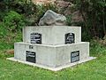
Rongo (memorial stone) to Taranaki Māori transported to Dunedin during the Land Wars.
See Also
