Small Down Knoll facts for kids
Quick facts for kids Small Down Knoll |
|
|---|---|
| Native name Small Down Camp | |

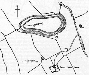
Plan of earthworks at Small Down Knoll
|
|
| Location | Evercreech, Somerset, England |
| Area | 2 hectares (4.9 acres) |
| Reference no. | 200348 |
| Lua error in Module:Location_map at line 420: attempt to index field 'wikibase' (a nil value). | |
Small Down Knoll, also known as Small Down Camp, is an ancient hill fort located near Evercreech in Somerset, England. This special place dates back to the Bronze Age. It sits on the southern edge of the Mendip Hills, reaching a height of 222 meters (728 feet).
Contents
A Look into the Past
Long, long ago, people lived at Small Down Knoll even before the hill fort was built. Archaeologists found flint tools here. These tools show that people were living and hunting in this area during the Mesolithic period, which was a very early time in human history.
The Fort's Structure
Small Down Knoll is a type of hill fort with many protective walls, called ramparts. These ramparts follow the natural shape of the hilltop. They enclose an area of about 2.4 hectares (6 acres).
Most of the fort has two ramparts. But on the flatter eastern side, there's an extra rampart with two clear ditches. These ditches would have made it harder for enemies to attack.
There are two ways to get into the fort on the south-east side. One entrance is a simple opening, and it looks like there might have been a guardhouse there. The other entrance shows signs of an old trackway, like a sunken path.
Ancient Burials
Inside the fort, you can find about 14 round barrows. These are ancient burial mounds, also called tumuli. They form a line running from east to west along the top of the hill.
Most of the fort and the burial mounds seem to be from the Bronze Age. However, when people dug into the site, they also found some pottery from the Iron Age in the barrows and ditches. This suggests the site was used for a long time.
Roman Connections
Small Down Knoll is located near the Fosse Way, which was a major Roman road in ancient Britain. There's also a nearby village called Stoney Stratton. Its name means "on the stony stone paved road," which suggests there was another local Roman road in the area. Even with these connections, no Roman or later remains have been found directly on the hill fort site itself.
Digging Up History
In 1904, a person named Mr. H. St. George Gray led an excavation at the fort. During this dig, they found many interesting things. These included flint tools, pieces of pottery, and burial sites with human remains. These finds help us understand more about the people who lived at Small Down Knoll long ago.
Protecting the Site
Small Down Knoll is a very important historical site. Because of this, it is protected as a Scheduled Ancient Monument. This means it's a nationally important archaeological site that is protected by law. It's also an "Open Access" area, which means people can visit and explore it.
 | Toni Morrison |
 | Barack Obama |
 | Martin Luther King Jr. |
 | Ralph Bunche |

