Socotra Rock facts for kids
Quick facts for kids Socotra Rock |
|
|---|---|

Socotra Rock location map
|
|
| Summit depth | 4.6 metres |
| Translation |
|
| Location | |
| Location | Yellow Sea |
| Coordinates | 32°07′22.63″N 125°10′56.81″E / 32.1229528°N 125.1824472°E |
| Socotra Rock | |
| Hangul |
이어도
|
|---|---|
| Hanja |
離於島
|
| Revised Romanization | Ieodo |
| McCune–Reischauer | Iŏdo |
| Parangdo | |
| Hangul |
파랑도
|
| Hanja |
波浪島
|
| Revised Romanization | Parangdo |
| McCune–Reischauer | P'arangdo |
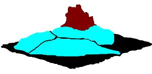
Socotra Rock is a special underwater rock in the Yellow Sea. It's also known by other names like Ieodo (Korean: 이어도; Hanja: 離於島; MR: Iŏdo), Parangdo (파랑도; 波浪鳥; P'arangdo), or Suyan Islet (simplified Chinese: 苏岩礁; traditional Chinese: 蘇巖礁; pinyin: Sūyán Jiāo). This rock is about 4.6 meters (15 feet) below the surface of the sea when the tide is low.
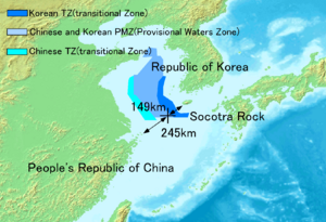
Even though it's underwater, Socotra Rock is important. International rules say that a submerged rock far from a country's coast (usually more than 12 nautical miles) cannot be claimed as land. However, this rock is part of a disagreement between China and South Korea. Both countries believe it is inside their special sea areas, called exclusive economic zones (EEZs).
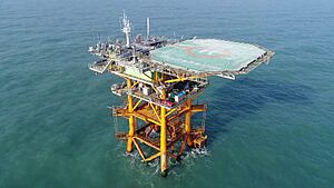
The rock is located about 149 kilometers (93 miles) southwest of Marado, an island near Jeju Island in Korea. It's also about 287 kilometers (178 miles) from Yushan Island in China. South Korea has built a research station, called the Ieodo Ocean Research Station, on top of this rock. There's even a helipad there for helicopters to land and help the station.
What Are Its Names?
In Korea, the rock is often called Ieodo or Parangdo. Around the world, it's known as Socotra Rock. In China, it's called Suyan Islet (simplified Chinese: 苏岩礁; traditional Chinese: 蘇巖礁; pinyin: Sūyán Jiāo). The Chinese name means "rock" or "reef" that is outside the coastal waters of Jiangsu, a province in China.
A Look at History
The names "Parangdo" and "Ieodo" come from old Korean stories. People from Jeju Island used to believe these were names for a magical island. They thought this island was where the spirits of fishermen who were lost at sea went. The government of South Korea says these old stories are connected to the real Socotra Rock. They say a traditional saying, "One who sees Parangdo would never return," warns sailors about the danger of the rock when big waves make it visible.
People in Korea even have a special name for studies about Ieodo: "Ieodology." On January 26, 2001, the Korea Institute of Geology officially named the rock "Ieodo."
Important Moments in Time
- 1900: A British merchant ship, the SS Socotra, discovered the rock. This is how it got the name Socotra Rock.
- 1951: A team from the Republic of Korea Navy and a mountain climbing group reached the rock. They placed a bronze marker there that said, "Ieodo, Territory of the Republic of Korea."
- 1952: South Korea announced the Syngman Rhee Line. This line claimed Socotra Rock was part of South Korea's waters. However, other countries like China did not agree with this.
- 1963: A Chinese ship called the Yuejin sank on its first trip. The crew first thought they were attacked. But it was later found that the ship hit Socotra Rock because of a navigation mistake.
- 1987: South Korea placed a warning beacon on the rock to help ships avoid it.
- 1995-2001: South Korea built the Ieodo Ocean Research Station on Socotra Rock. China did not agree with this construction.
- 2001: The Korea Institute of Geology officially named the rock "Ieodo."
The Disagreement
As we learned, international law states that a submerged reef, like Socotra Rock, cannot be claimed as a country's territory. However, China and South Korea disagree about which country has the right to include it in their exclusive economic zone (EEZ). An EEZ is a special area of the sea where a country has rights to explore and use marine resources.
In 2006, a spokesperson for China's Foreign Ministry, Qin Gang, said that China thought South Korea's activities there, like building the research station, were "illegal." But he also said there was no "territorial dispute" over the rock itself. Later, in 2013, China clarified that it did not have a dispute with Korea about this issue.
See also
- East China Sea EEZ disputes
- Foreign relations of the People's Republic of China
- Foreign relations of the Republic of Korea
- Liancourt Rocks
- Parangcho
- Parangdo (disambiguation)
- Senkaku Islands dispute
 | William Lucy |
 | Charles Hayes |
 | Cleveland Robinson |


