
Sonoma County landmarks facts for kids
Sonoma County, California, has many amazing places that are officially called "landmarks." These special spots are chosen by the county's Landmarks Commission. They are important because they tell us about the history and culture of Sonoma County.
These local landmarks are different from other famous places like National Historic Landmarks or sites on the National Register of Historic Places. They are also separate from California Historical Landmarks or places chosen by cities in Sonoma County. Each type of landmark has its own reasons for being special!
Contents
Sonoma County's Special Places
Sonoma County has a long list of places that are important enough to be called landmarks. These can be old buildings, farms, schools, churches, or even bridges! Each one has a story to tell about the past.
What Makes a Landmark Special?
A landmark is usually a place that has been around for a long time and has a unique history. It might be where something important happened, or it could be a great example of old architecture. By making these places landmarks, Sonoma County helps protect them so everyone can enjoy them for years to come.
Exploring Some Landmarks
Let's look at a few examples of these cool landmarks:
Freestone's Historic Spots
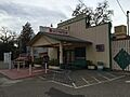
The small town of Freestone has several landmarks. For example, the Freestone Schoolhouse (Landmark #4) was built a long time ago. Imagine kids learning there many years ago! The Freestone Country Store (Landmark #5) is another old building that was once a busy place for people to buy supplies.
Historic Buildings in Sonoma
The city of Sonoma is home to many landmarks. The Buena Vista Winery (Landmark #18) is a very old winery that was restored in the early 2000s. It's even recognized as a California Historical Landmark and is on the National Register of Historic Places! Another interesting spot is Temelec Hall (Landmark #50), which also has a special state landmark number.
Churches and Schools with History
Many old churches and schools are also landmarks. The Church of Occidental (Landmark #12) in Occidental and Our Lady of Mount Carmel Church (Landmark #22) in Cloverdale are examples of historic places of worship. Schools like the Fort Ross School (Landmark #27) and the Potter School (Landmark #30) in Bodega remind us of how education used to be.
Bridges and Ranches
Some landmarks are not just buildings. Bridges, like the Guerneville Bridge (Landmark #173), are important parts of the county's history and transportation. Many old ranches, like the Haystack Ranch (Landmark #29) in Petaluma or the Martinelli Ranch (Landmark #183) in Windsor, show us what farming and ranching were like in the past.
Unique Landmarks
Some landmarks are truly unique! The Christo Running Fence (Landmark #24) in Valley Ford was a famous art project that stretched across the landscape. The Bufano Statue (Landmark #113) in Timber Cove is another artistic landmark. These show that landmarks can be more than just old buildings.
Images for kids
-
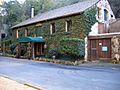
Buena Vista Winery
-
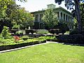
Temelec Hall
-
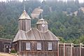
FtRoss
-
Alexander Valley Community Hall
-
Jimtown Store, February, 2021
-

Soda Rock Winery, January 2021


