
Cloverdale, California facts for kids
Quick facts for kids
Cloverdale, California
|
||
|---|---|---|

The Gould-Shaw House, a historic house in Cloverdale, is listed on the National Register of Historic Places.
|
||
|
||

Location of Cloverdale in Sonoma County, California
|
||

Cloverdale, California
Location in the United States
|
||
| Country | ||
| State | ||
| County | Sonoma | |
| Incorporated | February 28, 1872 | |
| Government | ||
| • Type | Council–manager | |
| Area | ||
| • Total | 3.13 sq mi (8.12 km2) | |
| • Land | 3.13 sq mi (8.12 km2) | |
| • Water | 0.00 sq mi (0.00 km2) 0% | |
| Elevation | 335 ft (102 m) | |
| Population
(2020)
|
||
| • Total | 8,996 | |
| • Density | 2,869.54/sq mi (1,107.82/km2) | |
| Demonym(s) | Cloverdalian | |
| Time zone | UTC-8 (PST) | |
| • Summer (DST) | UTC-7 (PDT) | |
| ZIP code |
95425
|
|
| Area code | 707 | |
| FIPS code | 06-14190 | |
| GNIS feature IDs | 277489, 2409487 | |
Cloverdale is a city in Sonoma County, California, United States. It is the westernmost and northernmost city in the San Francisco Bay Area. The San Francisco and North Pacific Railroad first arrived here in 1872. The Cloverdale Rancheria of Pomo Indians of California has its main office in Cloverdale. In 2020, about 8,996 people lived in the city.
Contents
History of Cloverdale
Cloverdale started as a stop for stagecoaches. It was first known as Markleville. In 1856, R.B. Markle and W.J. Miller bought the land where the town now stands.
Later, in 1859, James Abram Kleiser bought Markle's share. He then helped plan out the town. Cloverdale officially became a city when the San Francisco and North Pacific Railroad arrived in 1872. By 1878, trains ran three times a day between Cloverdale and Ferries of San Francisco Bay.
In 1881, Jules Leroux and Armand Dehay started a special community south of Cloverdale. It was called "Icaria Speranza" and was based on a French idea for a perfect society. This community ended in 1886. Today, a marker shows where its schoolhouse once stood.
Cloverdale faced tough times in the late 1980s and early 1990s. Many jobs were lost when a fire equipment factory closed and the logging industry shrank. In 1994, Highway 101, which used to go right through the town, was rerouted around it. This change caused some businesses to close. Many people felt it changed the town's feeling.
Since then, Cloverdale has been working to improve. It now has sidewalks that are easy to walk on, a performing arts center, and a downtown plaza. This plaza hosts live concerts and a farmers' market. In 1997, a new neighborhood called Clover Springs opened with 362 houses. In 2011, the city gained 250 acres (1.0 km2) of former ranchland. This land is now a park and open-space preserve for everyone to enjoy.
Cloverdale Rancheria of Pomo Indians
The Cloverdale Rancheria of Pomo Indians is a Native American tribe. They are recognized by the government and have almost 500 members. In 2008, the Tribe bought 80 acres (0.32 km2) of land at the south end of Cloverdale.
The Rancheria is a group of Pomo Indians. They are native to Sonoma County and speak the Southern Pomo language. Pomo people are famous for their amazing basket weaving. Both men and women create these beautiful baskets. Elsie Allen, a very skilled California basket weaver, was a member of this Rancheria. She spent part of her childhood there.
According to the tribe's history, the Pomo people lived peacefully in the area for a very long time. The Rancheria was created by the government in 1921. At that time, the tribe was officially recognized. They were given 27.5 acres (0.111 km2) of land on the southern edge of town.
However, in 1958, the Rancheria lost its official status. This happened to 43 other Native American rancherias in California. This process meant that tribal land was given to private owners.
In 1979, a Pomo woman named Tillie Hardwick started a legal case. She fought for 16 tribes that had lost their status unfairly. In 1983, the courts agreed. They gave back the official recognition to these tribes, including the Cloverdale Rancheria.
In 1994, the Highway 101 bypass was built through the Rancheria's land. This forced tribal landowners to sell their property for the freeway.
Since 2006, the tribe has been working to bring back their traditional culture. They are also looking into opening a casino to help their community.
Geography and Climate
Cloverdale is in the northern part of Sonoma County. It is about 85 miles (135 km) north of San Francisco. It is the northernmost and westernmost city in the San Francisco Bay Area.
The city covers about 2.6 square miles (6.7 km2) of land. There is no water within the city limits. Cloverdale is located in Wine Country. It is part of the Alexander Valley AVA, which is known for its vineyards.
Cloverdale's Weather
Cloverdale has a hot-summer Mediterranean climate. This means it has hot, dry summers and mild, wet winters. Temperatures in Cloverdale can often go above 100°F (38°C) in the summer. It is known for having hotter and drier summers compared to other parts of Sonoma County.
| Climate data for Cloverdale, California (1991–2020 normals, extremes 1950–present) | |||||||||||||
|---|---|---|---|---|---|---|---|---|---|---|---|---|---|
| Month | Jan | Feb | Mar | Apr | May | Jun | Jul | Aug | Sep | Oct | Nov | Dec | Year |
| Record high °F (°C) | 85 (29) |
86 (30) |
91 (33) |
102 (39) |
107 (42) |
116 (47) |
115 (46) |
114 (46) |
116 (47) |
106 (41) |
95 (35) |
83 (28) |
116 (47) |
| Mean maximum °F (°C) | 69.9 (21.1) |
75.0 (23.9) |
82.4 (28.0) |
89.9 (32.2) |
96.1 (35.6) |
105.0 (40.6) |
106.3 (41.3) |
105.5 (40.8) |
102.9 (39.4) |
94.8 (34.9) |
79.6 (26.4) |
68.1 (20.1) |
109.2 (42.9) |
| Mean daily maximum °F (°C) | 59.8 (15.4) |
63.4 (17.4) |
68.1 (20.1) |
73.8 (23.2) |
81.5 (27.5) |
89.4 (31.9) |
94.4 (34.7) |
93.1 (33.9) |
89.8 (32.1) |
80.6 (27.0) |
66.8 (19.3) |
58.7 (14.8) |
76.6 (24.8) |
| Daily mean °F (°C) | 49.1 (9.5) |
51.8 (11.0) |
55.2 (12.9) |
59.3 (15.2) |
65.7 (18.7) |
71.9 (22.2) |
74.8 (23.8) |
74.0 (23.3) |
71.7 (22.1) |
64.8 (18.2) |
54.6 (12.6) |
48.2 (9.0) |
61.8 (16.6) |
| Mean daily minimum °F (°C) | 38.3 (3.5) |
40.2 (4.6) |
42.4 (5.8) |
44.9 (7.2) |
49.8 (9.9) |
54.4 (12.4) |
55.2 (12.9) |
54.8 (12.7) |
53.6 (12.0) |
48.9 (9.4) |
42.3 (5.7) |
37.7 (3.2) |
46.9 (8.3) |
| Mean minimum °F (°C) | 29.3 (−1.5) |
31.6 (−0.2) |
34.4 (1.3) |
36.2 (2.3) |
42.4 (5.8) |
47.5 (8.6) |
50.2 (10.1) |
50.9 (10.5) |
47.1 (8.4) |
41.1 (5.1) |
33.0 (0.6) |
28.5 (−1.9) |
26.9 (−2.8) |
| Record low °F (°C) | 17 (−8) |
21 (−6) |
24 (−4) |
29 (−2) |
30 (−1) |
36 (2) |
40 (4) |
37 (3) |
29 (−2) |
28 (−2) |
25 (−4) |
17 (−8) |
17 (−8) |
| Average precipitation inches (mm) | 8.11 (206) |
8.06 (205) |
5.69 (145) |
2.53 (64) |
1.51 (38) |
0.30 (7.6) |
0.01 (0.25) |
0.05 (1.3) |
0.13 (3.3) |
1.84 (47) |
4.69 (119) |
8.81 (224) |
41.73 (1,060) |
| Average precipitation days | 13.1 | 11.3 | 10.5 | 7.5 | 4.5 | 1.0 | 0.1 | 0.2 | 0.9 | 3.8 | 8.3 | 12.2 | 73.4 |
| Source: NOAA | |||||||||||||
Population of Cloverdale
| Historical population | |||
|---|---|---|---|
| Census | Pop. | %± | |
| 1880 | 430 | — | |
| 1890 | 763 | 77.4% | |
| 1900 | 750 | −1.7% | |
| 1910 | 823 | 9.7% | |
| 1920 | 718 | −12.8% | |
| 1930 | 759 | 5.7% | |
| 1940 | 809 | 6.6% | |
| 1950 | 1,292 | 59.7% | |
| 1960 | 2,848 | 120.4% | |
| 1970 | 3,251 | 14.2% | |
| 1980 | 3,989 | 22.7% | |
| 1990 | 4,924 | 23.4% | |
| 2000 | 6,831 | 38.7% | |
| 2010 | 8,618 | 26.2% | |
| 2020 | 8,996 | 4.4% | |
| U.S. Decennial Census | |||
<graph>{ "version": 2, "width": 400, "height": 200, "data": [ { "name": "table", "values": [ { "x": 1880, "y": 430 }, { "x": 1890, "y": 763 }, { "x": 1900, "y": 750 }, { "x": 1910, "y": 823 }, { "x": 1920, "y": 718 }, { "x": 1930, "y": 759 }, { "x": 1940, "y": 809 }, { "x": 1950, "y": 1292 }, { "x": 1960, "y": 2848 }, { "x": 1970, "y": 3251 }, { "x": 1980, "y": 3989 }, { "x": 1990, "y": 4924 }, { "x": 2000, "y": 6831 }, { "x": 2010, "y": 8618 }, { "x": 2020, "y": 8996 } ] } ], "scales": [ { "name": "x", "type": "ordinal", "range": "width", "zero": false, "domain": { "data": "table", "field": "x" } }, { "name": "y", "type": "linear", "range": "height", "nice": true, "domain": { "data": "table", "field": "y" } } ], "axes": [ { "type": "x", "scale": "x" }, { "type": "y", "scale": "y" } ], "marks": [ { "type": "rect", "from": { "data": "table" }, "properties": { "enter": { "x": { "scale": "x", "field": "x" }, "y": { "scale": "y", "field": "y" }, "y2": { "scale": "y", "value": 0 }, "fill": { "value": "steelblue" }, "width": { "scale": "x", "band": "true", "offset": -1 } } } } ] }</graph> In 2020, Cloverdale had a population of 8,996 people. The city has grown steadily over the years.
Transportation and Schools
Getting Around Cloverdale
Cloverdale is located where U.S. 101 and State Route 128 meet. The city has its own local bus service called Cloverdale Transit. It also has the Cloverdale Municipal Airport. For travel between cities, people can use Sonoma County Transit.
There are plans to extend the Sonoma–Marin Area Rail Transit (SMART) train service to Cloverdale. This would connect the town to a ferry terminal in Larkspur. A train station is already built on the south side of town for this purpose.
Education in Cloverdale
Students in Cloverdale attend schools within the Cloverdale Unified School District.
Famous People from Cloverdale
- Elsie Allen (1899–1990), a famous Pomo basket maker and teacher.
- Fairuza Balk (born 1974), an actress, musician, and artist. She lived in Cloverdale as a baby.
- Lana Clarkson (1962–2003), an actress who grew up in Cloverdale.
- David Del Tredici (born 1937), a composer who won a Pulitzer Prize. He was born and lived his first four years in Cloverdale.
- Rich Rowland (born 1964), a former catcher for the Detroit Tigers baseball team.
Images for kids
-
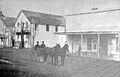
Cloverdale's first post office (around 1871–1880)
.jpg)
See also
 In Spanish: Cloverdale (California) para niños
