South Lake Worth Inlet facts for kids
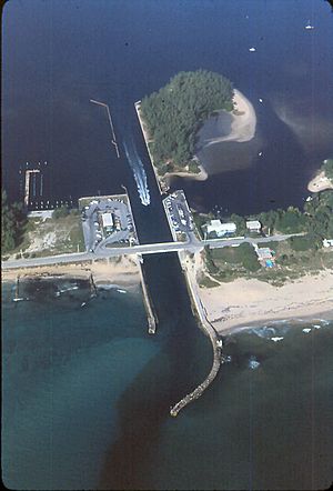
The South Lake Worth Inlet, also known as the Boynton Inlet, is a waterway made by people. It cuts through a narrow strip of land called a barrier beach. This inlet connects the southern part of the Lake Worth Lagoon in Palm Beach County, Florida to the Atlantic Ocean. It is about 130 feet (40 meters) wide and 6 to 12 feet (1.8 to 3.7 meters) deep.
Contents
Where is the Boynton Inlet Located?
The South Lake Worth Inlet is located at 26°32′44″N 80°02′34″W. To its north is the town of Manalapan. To its south is the town of Ocean Ridge. A place called Ocean Inlet Park is on the south side of the inlet. This park is owned by Palm Beach County and covers about 11.39 acres (4.61 hectares). It stretches from the ocean to the lagoon.
Why Was the Boynton Inlet Built?
A long time ago, in the mid-1800s, Lake Worth Lagoon was a freshwater lake. It had no connection to the ocean. Later, another inlet called the Lake Worth Inlet was dug at the north end of the lagoon in 1866. This changed the lagoon's water. It became more brackish, meaning a mix of fresh and salty water.
As more people moved to the area, the lagoon also started to get polluted. By 1913, local residents wanted a new inlet at the south end of the lagoon. They hoped this new opening would help flush out the polluted water into the ocean.
Building the Inlet and Keeping it Open
The State of Florida created a special district in 1915 to collect money for the South Lake Worth Inlet. Construction of the inlet began in 1925. The new inlet was finished in 1927. It cost $225,000 to build. When it was first opened, it was 130 feet (40 meters) wide and 8 feet (2.4 meters) deep.
Inlets on Florida's east coast often face a problem. Sand naturally moves south along the coast. This movement, called longshore drift, causes sand to build up against the north side of the inlet. This sand can then spill into the inlet and the lagoon, making them shallower. It also causes the beach south of the inlet to wear away.
To fix this, the walls (jetties) of the inlet were made taller. In 1937, a special sand transfer plant was built on the north jetty. This was the first plant of its kind! Its job was to pump sand from the north side of the inlet to the south side. This helped keep the inlet clear and protected the beaches.
The plant pumped about 50,000 cubic yards (38,227 cubic meters) of sand each year for five years. During World War II, the plant had to stop working due to a lack of fuel. Sand then built up again in the inlet and lagoon. After the war, the sand transfer started again. Workers also began dredging, which means removing the built-up sand from the inlet and lagoon. The sand transfer plant has been updated several times, including in 1948, 1967, 1998, and was rebuilt in 2011.
Boating Through the Inlet
State Road A1A crosses over the inlet on a bridge. This bridge is fixed, meaning it doesn't open, and is 18 feet (5.5 meters) above the water. The water depth in the inlet can be between 6 feet (1.8 meters) and 12 feet (3.7 meters).
The South Lake Worth Inlet was not originally planned for boats. However, many recreational boaters use it today. The inlet is known for being tricky to navigate. This is because of sand build-up, strong currents, and narrow spaces. In 2006, more than 46,000 boat trips went through the inlet. That same year, seven boats needed to be rescued in the inlet.
 | Laphonza Butler |
 | Daisy Bates |
 | Elizabeth Piper Ensley |


