
South Luzon Expressway facts for kids
The South Luzon Expressway, often called SLEx or SLEX, is a special road in the Philippines. It's designed for fast travel, connecting the big city area of Metro Manila to the provinces in the southern part of Luzon, which is the country's main island.

This important road is about 51 kilometers (or 32 miles) long. It starts in Paco, a part of Manila, where it meets Quirino Avenue.

As you travel along SLEX, it passes through many cities and towns. In the capital area, it goes through Makati, Pasay, Parañaque, Taguig, and Valenzuela. Then, it continues into the provinces of Cavite and Laguna in Southern Luzon.
The expressway finishes in Santo Tomas, a town in the province of Batangas. From there, it smoothly connects to another major road called the Southern Tagalog Arterial Road, also known as STAR Tollway.
Images for kids
-
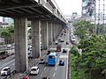
Skyway At-Grade southbound below Skyway, south of Sucat Interchange
-
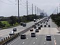
SLEX southbound in Carmona
-
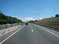
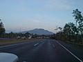
SLEX Toll Road 3 southbound in Calamba
-
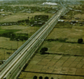
SLEX near the original Alabang Toll Plaza in 1976
-
SLEX Calamba segment in 2007, prior to the completion of rehabilitation work
(2017-05-25)_2.jpg)
_-_Carmona_(Carmona,_Cavite;_2017-03-16).jpg)


