South Suicide Peak facts for kids
Quick facts for kids South Yuyanq’ Ch’ex |
|
|---|---|

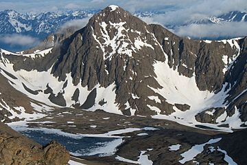
South Yuyanq’ Ch’ex, as seen from nearby Ptarmigan Peak
|
|
| Highest point | |
| Elevation | 5,005 ft (1,526 m) |
| Prominence | 1,004 ft (306 m) |
| Geography | |
| Parent range | Chugach Mountains |
| Climbing | |
| Easiest route | Most often climbed via Hauser's Gully |
South Yuyanq’ Ch’ex, once called "South Suicide Peak," is a tall mountain in Alaska, U.S.. It stands at 5,005 feet (1,526 meters) high. This amazing peak is found inside Chugach State Park. It's famous for its neat pyramid shape. It looks very similar to its neighbor, North Yuyanq’ Ch’ex. It is also the tallest mountain rising from the north side of Cook Inlet's Turnagain Arm.
Where is South Yuyanq’ Ch’ex Located?
South Yuyanq’ Ch’ex is on the southern edge of Chugach State Park in Alaska. It sits between several other important landmarks. These include North Yuyanq’ Ch’ex, Indianhouse Mountain, Rabbit Lake, and McHugh Peak.
Exploring and Climbing This Mountain
South Yuyanq’ Ch’ex is a popular spot for climbers. This is because it is close to Anchorage, Alaska. It is also easy to reach from many different walking paths.
Climbing South Yuyanq’ Ch’ex is considered a tough but not technical one-day trip. This is true when there is no snow on the mountain.
People often climb South Yuyanq’ Ch’ex using these main paths:
- Hauser's Gully: This path goes up the northern side of the mountain. It starts steeply from the rocky areas between North and South Yuyanq’ Ch’ex, next to Rabbit Lake.
- Windy Gap Pass: This route goes through a pass between North Yuyanq’ Ch’ex and South Yuyanq’ Ch’ex.
- Falls Creek Trailhead: You can also climb from the south side and ridge. This path starts at the Falls Creek trailhead.
- Western Ridge: This route can be reached from either Rainbow Peak or the upper McHugh Creek trail.
 | Isaac Myers |
 | D. Hamilton Jackson |
 | A. Philip Randolph |


