South West Cape (Tasmania) facts for kids
Quick facts for kids South West Cape |
|
|---|---|

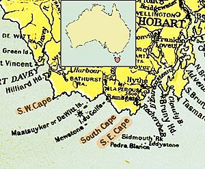
1916 map of the south coast of Tasmania, showing South West Cape.
|
|
| Location | South West Tasmania |
| Coordinates | 43°34′12″S 146°01′48″E / 43.57000°S 146.03000°E |
| Geology | Cape |
| UNESCO World Heritage Site | |
| Official name | Tasmanian Wilderness |
| Location | Oceania |
| Criteria | iii, iv, vi, vii, viii, ix, x |
| Inscription | 1982 (6th Session) |
South West Cape is a special piece of land in Tasmania, Australia. It's a point of land that sticks out into the ocean. This cape is located at the very south-west corner of Tasmania. It is part of a wild and beautiful area.
Contents
Exploring South West Cape
South West Cape is found in the south-western part of Tasmania. It is about 140 kilometers (87 miles) southwest of Hobart. Hobart is the capital city of Tasmania. The cape is also about 65 kilometers (40 miles) west of South East Cape.
Where is South West Cape Located?
This cape is inside the Southwest National Park. This park is part of the amazing Tasmanian Wilderness World Heritage Area. A World Heritage Area is a place recognized by UNESCO. It has special natural or cultural importance.
The cape is surrounded by the Indian Ocean. This ocean is to its southeast and southwest. Other nearby points of land include Low Rocky Point and Point Hibbs to the north.
The South West Cape Range
The South West Cape Range is a line of hills. It acts like a natural wall. This range separates the cape from the wild land further inland. The next line of hills to the east is called the Melaleuca Range.
The highest point near the cape in this range is Mount Karamu. It stands 439 meters (1,440 feet) tall. Mount Karamu got its name from a ship. The USS Karamu was a steamship that sank near the cape in 1925.
Why is South West Cape Important?
South West Cape is a very important landmark for sailors. When ships have problems or sink, even far away, this cape is often used. It helps people identify where the event happened. Maps of the coast also use the cape as a clear boundary. It helps divide different parts of the coastline.


