
Southern Boulevard Parkway facts for kids
| Pennsylvania Route 611 | |
| Type | Parkway – urban park |
|---|---|
| Location | Philadelphia, Pennsylvania |
| Coordinates | 39°55′01″N 75°10′16″W / 39.917°N 75.171°W |
| Construction | |
| Commissioned | 1914 by Olmsted Brothers |
Southern Boulevard Parkway is a special part of south Broad Street in Philadelphia, Pennsylvania. It's like a long, green pathway that connects two parks: Marconi Plaza and FDR Park. This parkway stretches from Oregon Avenue south to the entrance of the Philadelphia Navy Yard.
The parkway has a beautiful green area in the middle. It also has tree-lined sidewalks and small green spaces. These areas separate the traffic lanes. The parkway is surrounded by homes, the South Philadelphia Sports Complex, and the Philadelphia Navy Yard.
Contents
How the Southern Boulevard Parkway Began
In 1904, people started planning to improve parks and roads in South Philadelphia. Samuel Parsons Jr. drew up a design, but work stopped for a while. Then, in 1912, the city hired a famous landscape design company called Olmsted Brothers.
Olmsted Brothers' Vision for the Parkway
The Olmsted Brothers created plans for League Island Park and the area around Oregon Plaza. They also designed the stretch of south Broad Street. Their plan connected the two parks with a green space in the middle and tree-lined sidewalks. These parks were built on land that used to be swampy.
Olmsted's main idea was to make open spaces available to everyone. He wanted to combine the best parts of city life and country life. His goal was to create a "Suburban Village." This meant blending nature with city areas. He hoped it would offer fresh air and quiet places for outdoor fun. This design helped the area grow into a lively community over the next 100 years. It became a place for homes, recreation, and big sporting events.
The Parkway's Role in the 1926 World's Fair
The Boulevard was the main entrance for the 1926 Sesquicentennial Exposition. This was a big world's fair held in Philadelphia. It celebrated 150 years since the United States Declaration of Independence. It also marked 50 years since the 1876 Centennial Exposition.
What the Exposition Looked Like
During the fair, the Boulevard was lined with linden trees and flowering crab apple trees. There were also open green areas and parking. Huge buildings for the fair stood on either side. Thirteen tall, thin monuments called "Founders Pylons" represented the original 13 colonies.
A giant replica of the Liberty Bell stood 80 feet tall at Oregon Plaza. It weighed 27 tons! At night, the Boulevard was lit up. The huge Liberty Bell had 26,000 light bulbs. Searchlights from the Founder Pylons shone into the sky. Lights also shot from the Tower Of Light. It was a spectacular sight for that time!
After the fair, most of the temporary buildings were taken down. But the area kept growing. In the 1960s, a new stadium, a bowling alley, and a movie theater were built. An aquarium called Aquarama Aquarium Theater of the Sea also opened. Later, Veterans Stadium and Spectrum were built for professional sports. These have since been replaced by two new stadiums, an arena, and a dining and entertainment area.
In the 1950s, the green space of the Boulevard became part of the Fairmount Park system. It was officially called Southern Parkway. However, today, most people just call it part of Broad Street.
Images for kids
-
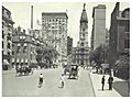
South Broad Street, looking towards City Hall (c. 1895)
-
North Broad Street, looking towards City Hall
-
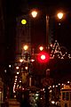
Broad Street at night along the Avenue of the Arts, looking north towards City Hall, 2005
-
Broad Street in the Cecil B. Moore area near Temple University
-
The Northern end of Broad Street on the border of Philadelphia and Cheltenham Township
-
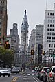
Image of City Hall from North Broad Street showing the new lighting masts. The lighting masts begin a block south of Spring Garden Street and move north.
-
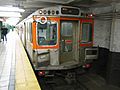
SEPTA's Broad Street Line provides subway service along much of Broad Street
-
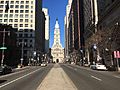
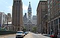
Broad Street north of Walnut Street in Center City Philadelphia, approaching Philadelphia City Hall
_p18_BROAD_STREET,_NORTH_FROM_WALNUT.jpg)


See also
 In Spanish: Broad Street (Filadelfia) para niños
