Southern Patagonian Ice Field dispute facts for kids
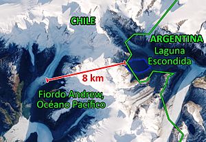
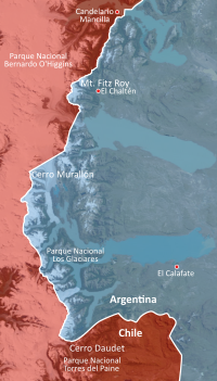
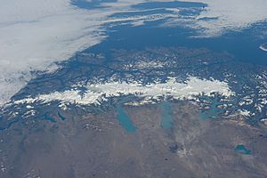
The South Patagonian Ice Field dispute is a disagreement between Argentina and Chile. It's about where the border line should be drawn across the Southern Patagonian Ice Field. This ice field is a massive area of glaciers in the Andes mountains. It's the largest ice field outside the North and South Poles that you can reach by land. In Argentina, it's called "continental ice," and in Chile, it's known as the "southern ice field." As of 2023, the exact border in this icy region is still not fully marked.
Contents
How the Border Problem Started
Early Border Agreements
The border between Argentina and Chile was first set by a treaty in 1881. This treaty said the border would follow the highest peaks of the Andes mountains that also divide the waters. This means that rivers flowing to one side would belong to one country, and rivers flowing to the other side would belong to the other.
In 1888, both countries agreed to start marking the border. They appointed experts, Diego Barros Arana for Chile and Octavio Pico Burgess for Argentina. But they soon disagreed on how to interpret the treaty.
Because of these disagreements, the border marking stopped in 1892. Then, in 1893, they signed another agreement called the Boundary Protocol. This protocol made it clearer:
All land and water (like lakes, rivers, and streams) east of the highest peaks of the Andes that divide the waters will belong to Argentina. All land and water west of these peaks will belong to Chile.
This protocol is very important. If the glaciers melt, new paths for water could open up, potentially changing where the border should be.
In 1898, the experts, including Francisco Pascasio Moreno for Argentina and Alejandro Bertrand for Chile, agreed on some points. They marked Mount Fitz Roy and Mount Stokes as border points. However, they hadn't actually visited the area, so they noted that changes might be needed if their maps weren't exact.
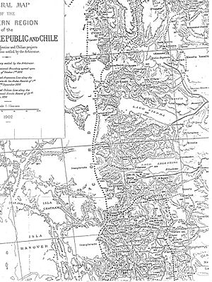
When the experts couldn't agree on other parts of the border, they asked the British monarch, Queen Victoria, to help decide. In 1901, a British judge, Colonel Thomas Holdich, visited the disputed areas.
Argentina believed the border should follow the highest mountain peaks. Chile thought it should follow where the waters divided. The judges found the original treaties unclear. On May 20, 1902, King Edward VII made a decision. He said that the border between Mount Fitz Roy and Mount Stokes was already decided because the high peaks there also divided the waters. But the exact line in the ice field between these two mountains was still not marked.
Marking the Border Later On
In 1941, a new agreement created the Joint Commission on Boundaries (COMIX). This group, made up of experts from both countries, was tasked with marking the border using the 1881 and 1893 agreements.
In 1990, the presidents of Argentina and Chile, Carlos Saúl Menem and Patricio Aylwin, asked the Joint Commission to speed up their work. The Commission identified 24 areas where the border still needed to be marked. They managed to resolve 22 of these areas.
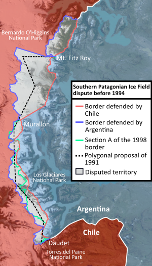
For the ice field, Chile's experts suggested a line connecting several peaks like Torre, Murallón, and Cervantes. Argentina's experts, using newer mapping techniques, proposed a line following the highest peaks that divide waters, including Murallón, Torino, and Agassiz. Only two points, Murallón and Bolados hills, were on both proposed routes.
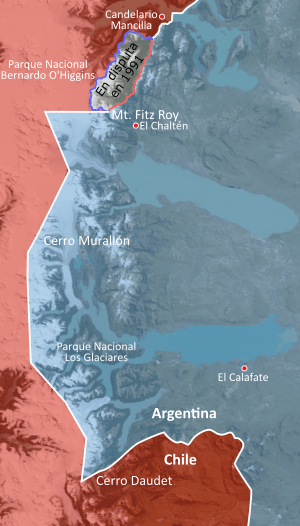
In 1991, Presidents Menem and Aylwin signed an agreement to draw a straight "polygonal line" to divide the disputed area from Mount Fitz Roy to Mount Stokes. This line would have ignored the original "highest peaks dividing waters" rule.
This polygonal line was not approved by the governments in either country. Argentina felt it would lose 1057 square kilometers of Los Glaciares National Park, and Chile felt it would lose 1238 square kilometers of Bernardo O'Higgins National Park.
The 1998 Agreement
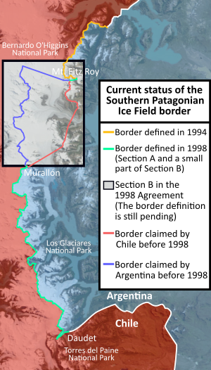
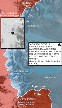
On December 16, 1998, a new agreement was signed. This agreement aimed to set the border from Mount Fitz Roy to Mount Daudet. It went back to the original idea of "highest peaks that divide waters" from the 1881 Treaty. It also made sure Chile could still access Mount Fitz Roy and Argentina could access Mount Stokes.
The agreement divided the territory into two main parts:
- Section A: From Murallón Hill to Daudet Hill. The border follows the watershed (where waters divide) through several hills. In some parts, it uses straight lines to connect specific points.
- Section B: From Mount Fitz Roy to Cerro Murallón. From Mount Fitz Roy, the line goes down along the watershed to a specific point. Then, it follows a straight line to another point. After that, it follows a parallel line westward, based on earlier agreements.
In a specific rectangular area between Mount Fitz Roy and Mount Murallón, the Joint Boundary Commission still needs to create a detailed map to mark the border. This means that part of the border is still not fully defined on the ground.
The agreement also stated that all waters flowing into and out of the Santa Cruz River belong to Argentina. All waters flowing towards the Pacific Ocean fjords belong to Chile. Both countries promised not to change the amount or quality of water belonging to the other.
Areas Still Not Marked
In 2006, a photo of then-Chilean President Ricardo Lagos in the unmarked area caused a small controversy with Argentina.
The Joint Commission on Boundaries, which was supposed to create the detailed map for demarcation, had not yet been formed by August 2006. Both countries then issued statements, with Argentina reminding Chile to start the demarcation work. This exchange happened because Chile complained that Argentine maps didn't show the rectangular unmarked area.
In 2006, Presidents Michelle Bachelet of Chile and Néstor Kirchner of Argentina met to discuss the map disagreement.
Even today, maps published in Argentina often don't show the white rectangle for the unmarked area. However, official Chilean maps and most tourist maps do show it, explaining that the border is not yet marked according to the 1998 treaty.
In 2008, the Argentine army began flights to survey the area for mapping, with Chilean personnel observing.
In 2018, Argentina included some disputed glaciers in its National Ice Inventory. Later that year, the Argentine army traveled into the unmarked area. This caused controversy in Chile, with the mayor of Villa O'Higgins calling it a "provocation." Chile's Foreign Ministry sent a formal complaint about Argentina's glacier inventory.
In 2021, there was another disagreement when a Chilean organization (CONAF) set up a dome in the Circo de los Altares, an area claimed by both countries.
As of 2026, the border in this part of the ice field is still not fully marked.
See also
 In Spanish: Litigio del campo de hielo patagónico sur para niños
- Laguna del Desierto incident
- Beagle conflict
- Puna de Atacama
- Cordillera of the Andes Boundary Case
- Argentina-Chile relations
 | Jewel Prestage |
 | Ella Baker |
 | Fannie Lou Hamer |


