
Southern Patagonian Ice Field facts for kids
Quick facts for kids Southern Patagonian Ice Field |
|
|---|---|
 |
|

Location in Southern Patagonia
|
|
| Type | Ice field |
| Location | Argentina and Chile |
| Coordinates | 49°55′S 73°32′W / 49.917°S 73.533°W |
| Area | 16,800 km2 (6,500 sq mi) |
| Status | Retreating |
The Southern Patagonian Ice Field is a huge area of ice and snow. It's located in the Andes mountains, between Chile and Argentina. This ice field is the second largest of its kind outside of the North and South Poles!
It's a leftover piece of a much bigger ice sheet. This giant ice sheet once covered all of southern Chile during the last ice age.
Contents
Exploring the Ice Field
The Southern Patagonian Ice Field stretches for about 350 kilometers (217 miles). It covers an area of around 16,480 square kilometers (6,360 square miles). Most of this ice field, about 14,200 square kilometers, is in Chile. The rest, about 2,600 square kilometers, is in Argentina.
Glaciers and Waterways
This massive ice field feeds many glaciers. Some of the most famous glaciers include:
- The Upsala Glacier, which is very large.
- The Viedma Glacier.
- The Perito Moreno Glacier, known for its amazing ice collapses. These are all in Los Glaciares National Park in Argentina.
In Chile, you'll find:
- The Pío XI Glacier, which is the largest and longest in the Southern Hemisphere outside of Antarctica.
- The O'Higgins Glacier.
- The Grey Glacier.
- The Tyndall Glacier.
Glaciers on the western side flow into the fjords of the Pacific Ocean. Glaciers on the eastern side flow into lakes like Lake Viedma and Lake Argentino. From these lakes, the water eventually reaches the Atlantic Ocean through rivers.
Protected Areas and Hidden Volcanoes
A big part of the ice field is protected by national parks. These include Bernardo O'Higgins National Park and Torres del Paine National Park in Chile. In Argentina, it's part of Los Glaciares National Park.
There are also two known volcanoes hidden under the ice field: Lautaro and Viedma. Because they are so hard to reach, they are some of the least studied volcanoes in Chile and Argentina.
History of the Ice Field
Early Explorations
People have been exploring this vast ice field for a long time. Some important expeditions include:
- Federico Reichert (1913–1914)
- Alberto de Agostini (1931)
- Harold William Tilman and Jorge Quinteros (1955–1956)
- Eric Shipton (1960–61)
The first time someone crossed the entire ice field from north to south was in 1998. This amazing journey was completed by Pablo Besser, Mauricio Rojas, José Montt, and Rodrigo Fica. Even today, some parts of the ice field are still largely unexplored.
Airplanes also helped explore the area. Gunther Plüschow flew over it in 1928–29. Later, in 1943, the United States Air Force took aerial photographs for the Chilean government.
The Border Question


A small part of the border between Chile and Argentina, about 50 kilometers (31 miles) long, is still not fully decided. This section is on the ice field, between Mount Fitz Roy and Cerro Murallón.
This is the last remaining border issue between the two countries. In 1991, they tried to agree on a border line, but it wasn't fully approved. Later, in 1998, they agreed that the border would follow the highest peaks and where the water divides. However, they decided to wait for more detailed maps and talks to finalize the exact line. This small part of the border is still being discussed today.
Images for kids
-
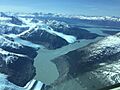
Campo de Hielo Sur Patagonia
-
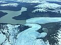
Lago Bergues, campo de Hielo sur
-
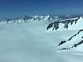
Campo de Hielo Sur
-
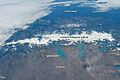
Southern Patagonia Ice Field from ISS, astronaut photo. North is to the right.


See also
 In Spanish: Campo de hielo patagónico sur para niños
- Southern Patagonian Ice Field dispute
- Northern Patagonian Ice Field
- List of glaciers
- Argentina-Chile relations
