Southfield, Staten Island facts for kids
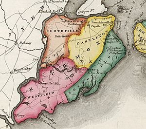
Southfield was a town that used to exist in Richmond County, New York. It was located on the southeastern part of Staten Island. This was before Staten Island became part of New York City in 1898. The town was next to Lower New York Bay. Its western border was near roads like Richmond Road and Amboy Road.
Contents
What Was Southfield?
Southfield was one of the first towns on Staten Island. It was created by English colonists. This happened in the late 1600s. The English had taken over the land from the Dutch in 1664.
Southfield Becomes a Town
Southfield officially became a town in 1788. It was one of the four original areas of Richmond County. Later, in 1860, a new town called Middletown was formed. Parts of Southfield and another town, Castleton, were used to create it. A famous place called Fort Wadsworth is located in the area that was once Southfield.
The End of Southfield
In 1898, Southfield stopped being a separate town. This happened when Staten Island joined to form the larger City of New York. All the towns on Staten Island became part of the big city.
Southfield Today: Modern Neighborhoods
Even though Southfield is no longer a town, its land is still part of Staten Island. Today, several neighborhoods are in the area where Southfield used to be. These include:
 | Aaron Henry |
 | T. R. M. Howard |
 | Jesse Jackson |


