
Spango Valley facts for kids
Quick facts for kids Spango Valley |
|
|---|---|
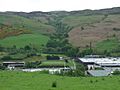
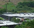
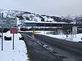
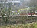
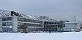
 Spango Valley from Langhill |
|

Spango Valley
|
|
| OS grid reference | NS 2332 7441 |
| Council area | |
| Lieutenancy area | |
| Country | Scotland |
| Sovereign state | United Kingdom |
| Post town | GREENOCK |
| Postcode district | PA16 |
| Dialling code | 01475 |
| EU Parliament | Scotland |
| UK Parliament |
|
| Scottish Parliament |
|
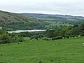
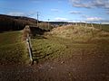
Spango Valley is a valley in Scotland, located southwest of Greenock. It stretches for about 1.5 miles (2.4 km) from Dunrod Farm to Ravenscraig. A small stream called the Spango Burn flows through the valley. This stream used to wind around, but much of it has been straightened over time.
Contents
The IBM Years
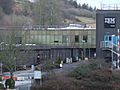
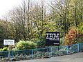
IBM, a famous technology company, opened a factory in Spango Valley in 1954. At first, they made typewriters and other office machines. Over the years, the factory grew bigger and bigger, reaching about 1 mile (1.6 km) long. IBM started making different things, like bank terminals and then Personal Computers (PCs) in the early 1980s.
The first factory building was built where Kingston Farm used to be. The last building IBM added was a call centre, which replaced Spango Farm. Some other farms, like Dunrod, Chrisswell, Flatterton, and Leitchland, are still in the valley.
By 2009, parts of the IBM factory were taken down. This happened because IBM sold some of its PC making business to other companies. The land and remaining buildings were then sold and renamed Valley Park. IBM rented some buildings back from Valley Park for a while. Another company, the National Microelectronics Institute, also used space there. IBM completely left the valley in October 2016, moving to another part of Greenock. By September 2020, all the old IBM buildings had been taken down.
IBM Gallery
-
Spango Valley: view of IBM railway station and the "Hole of Spango" from Ailleymill Road
-
Buildings at the south end of the IBM campus
-
IBM buildings in 2009
-
Sanmina SCI branding on the former IBM Automated Materials Distribution Centre building
-
IBM Reception in 2008
-
IBM Automated Materials Distribution Centre building
-
IBM buildings in 2008
-
IBM main access road in 2007
-
IBM call centre building in 2009
-
A plastic building which housed a lab to test computer products for electrical emissions
-
This 2013 photo shows that much of the factory has been demolished
-
This 2013 photo shows that much of the factory has been demolished


Roads in the Valley
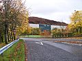
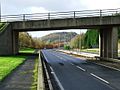
In the early 1980s, the main road through Spango Valley, called the A742 Inverkip Road, was made much bigger. It was turned into a dual carriageway, meaning it had two lanes going in each direction. This was done to handle all the extra cars and trucks going to the IBM factory and the nearby Inverkip Power Station. The power station has also been taken down since then.
At that time, the road was given a new number, A78, and became a very important "trunk road." The old A78 road, which went through Gourock, was then renamed A770.
Inverkip Road Gallery
-
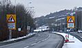
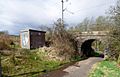
The "IBM flyover" which provided access to the IBM campus from the A78
-
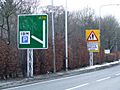
New road signs on the approach to the (by now mostly derelict) IBM campus
-
Pedestrians crossing warning signs on the approach to the IBM campus
-

Warning sign at the pedestrian crossing point at the IBM campus


Railway History
A railway line was built through Spango Valley in 1865 by the Greenock and Wemyss Bay Railway Company. It connected Port Glasgow to Wemyss Bay. There was a station called Ravenscraig at the north end of the valley, which was used from 1865 to 1944.
Today, this railway line is part of the Inverclyde Line. Electric trains run on this single track between Glasgow Central and Wemyss Bay. The line passes along the east side of the valley, between Branchton and Inverkip stations.
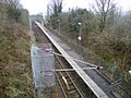
A special train station, IBM railway station, opened in May 1978 to serve the IBM factory. It was originally called IBM Halt. However, after the IBM factory was taken down, train services to this station were stopped on December 8, 2018.
There was also a smaller branch line that left the main railway line near Dunrod Farm. This line was about 1 mile (1.6 km) long and went to sandstone quarries in Shielhill Glen.
Railway Gallery
-

IBM Halt in 2009
-
IBM Halt in 2009
-
IBM Halt in 2009
-
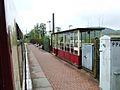
IBM Halt in 2007
-
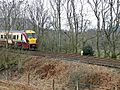
A train at the south end of the valley
-
A train passing the IBM boiler house
-
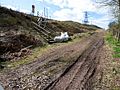
Remains of the mineral line line junction at Dunrod in 2006
-
Site of Ravenscraig railway station
-
Site of Ravenscraig railway station


.jpg)


Schools in the Valley
Two schools used to be located next to each other at the north end of Spango Valley. They shared a road that crossed the Spango Burn.
- Greenock High School opened its new building here in 1971.
- The new Glenburn Special Needs School opened in the 1960s.
By 2014, both schools had closed and their buildings were taken down. Glenburn School moved to a new "super campus" in Port Glasgow. Greenock High School joined with Grovepark High School to become Inverclyde Academy.
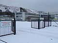
The land where the schools once stood was later prepared for a new prison for women. A new road and bridge were even built. However, the Scottish Government decided not to build the prison. This was because they changed their plans for how women are kept in prison. So, as of December 2020, the site is still fenced off and not being used.
Schools in the valley Gallery
-
Greenock High School in 2005
-
Greenock High School awaits demolition in 2009
-
Greenock High School awaits demolition in 2009
-
Former Greenock High School building in 2008
-
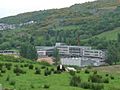
Greenock High School and Glenburn School can be seen in this view


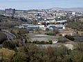
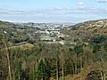
What the Valley Looks Like Now
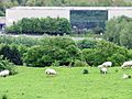
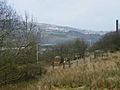
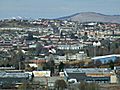
Most of the valley floor today (December 2020) is a "brownfield site." This means it's land that was used for industry or buildings in the past and is now empty. This area stretches for about 1.3 miles (2.1 km). The rest of the valley is farmland, with some houses on the edges to the north.
