
Spring Creek Forest Preserve facts for kids
The Spring Creek Forest Preserve is a special nature area in Garland, Texas, a city near Dallas. It's a place where you can explore an amazing old forest, right inside the city!
Contents
How This Special Place Was Saved
Back in 1978, a man named Bobby C. Scott, who loved plants and taught himself a lot about them, found something incredible. He noticed that some trees in a part of the woods in Garland, Texas looked like they were from a very old, untouched forest. This was super unusual because most forests in the area were cut down long ago by settlers to build homes or clear land for farms.
For the next ten years, Mr. Scott worked hard to protect this area, which he called the Spring Creek Forest. He teamed up with another nature lover, Edward C. "Ned" Fritz. Together, they showed the City of Garland and Dallas County, Texas why this forest was so important. Experts, including botanists (plant scientists) from universities and the government, agreed that the forest was truly unique. They even found rare plants there!
Because of their efforts, in 1988, Dallas County and the State of Texas bought 69 acres of this land to create the Spring Creek Forest Preserve. The City of Garland helps take care of it. Since 1987, the City of Garland and a group called the Preservation Society for Spring Creek Forest have been working together to keep the walking trails nice for visitors.
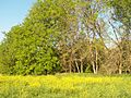
Exploring the Forest's Amazing Landscape
The Spring Creek Forest Preserve is located in northern Dallas County. It has a special kind of old forest called a "bottomland forest," which grows near a gentle, wide stream. This stream, Spring Creek, flows over a bed of solid limestone.
The water in the creek has been flowing for so long that it has carved out tall cliffs, some as high as 20 to 40 feet! These cliffs are made of a rock called Austin Chalk. Inside these cliffs, you can find Cretaceous fossils that are about 87 million years old! This mix of old forest, limestone, and ancient fossils is very rare and mostly found right here in Garland.
Spring Creek is fed by natural springs, so its water stays a constant 72°F (22°C). The water moves quickly and is usually between one and six feet deep, and about 20 feet wide. Even when there's a drought, the creek keeps flowing. The water is so clear that you can often see native Longear Sunfish swimming over the white limestone bottom.
The steady water supply has helped this forest survive for hundreds of years. Some of the trees are as old as 500 years! They can be 100 feet tall with trunks that are 4 feet wide. You can find five different kinds of oak trees here, including chinquapin, bur, and shumard oaks. This specific combination of oaks isn't found anywhere else in the world!
Besides the trees, the forest is home to many other native plants like solomon's seal, horsetails, and Pennsylvania violets. Scientists have observed over 630 different kinds of plants and animals in the preserve, plus many types of dragonflies, spiders, beetles, and fungi. It's a busy place!
Keeping the Forest Safe and Natural
The Spring Creek Forest Preserve is a shady place with miles of dirt trails. There's also a short concrete path from the parking lot to the water. This land was protected because of its unique old trees and rare plants. The preserve's website has thousands of photos of the landscape, flowers, and wildlife.
The people who care for the forest want to keep it as natural as possible. This way, visitors can imagine what the area was like before settlers arrived in 1846. Every February, the preservation society holds nature walks to celebrate the blooming of the trout lily. This beautiful wildflower is a sign that spring is coming for people living nearby. These walks usually attract 30 to 50 nature lovers each year.
Spring Creek flows through solid limestone in three different cities. However, only two areas along the creek have been officially protected. One is the Spring Creek Forest Preserve in Garland. The other is the Dallas County Park Preserve, owned by Dallas County. These two parks are right across the street from each other on Holford Road. Most of Spring Creek's length has been surrounded by homes and office buildings for decades. These two parks are some of the last remaining natural areas that were once home to the Caddo nation tribes.
The total protected area is made up of two parts. The Lee F. Jackson Spring Creek Forest Preserve, where official tours happen at 1770 Holford Rd., is about 83 acres. The Dallas County Park Preserve, across the bridge at 1787 Holford Rd., is about 33 acres.
The Spring Creek Forest Preservation Society, a group of volunteers, helps manage the preserve. They work with the Garland Parks and Recreation Department. This volunteer group holds monthly meetings and workdays to help keep the park beautiful. You can find their calendar on their website to learn about meeting times and locations.
The land for the preserve was originally bought from private owners, including Ann C. Weary, who was known for her detailed sketches of the trees.
The Future of Spring Creek
Today, there are still many undeveloped areas along Spring Creek that could be protected. However, because there isn't enough money from the county, private landowners might sell their land to companies that want to build stores or offices. The city has even planned to build playgrounds and soccer fields right along the creek's banks.
Development in this area started to increase when the 190 Bush Tollway was completed, as it passes directly over Spring Creek. Major projects nearby include the Firewheel Golf Course and the Firewheel Town Center, which is a large shopping mall. This area is becoming a popular spot for business travelers because it's close to Richardson's "Telecom Corridor," a hub for technology companies.
The middle part of Spring Creek flows near the Owen's Sausage processing plant and several tall computer technology buildings. Large stores like Walmart and Sam's Club were built very close to the preserve, and the headwaters of Spring Creek actually flow underneath Collin Creek Mall in Plano.
As more businesses develop, the value of the remaining land along Spring Creek is going up very quickly. City officials say that Garland is now "landlocked," meaning it's surrounded by other suburbs. This puts the remaining natural areas on private land at risk of being developed. Many people hope that a generous person or group will come forward to buy and protect these special areas, including the unique limestone cliffs and large groups of trout lilies.
Images for kids
-
Spring Creek Forest Preserve

