
Springbank Island facts for kids
.jpg)
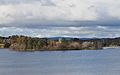
Springbank Island in the foreground of Black Mountain, behind
|
|
| Geography | |
|---|---|
| Location | Lake Burley Griffin, Canberra () |
| Coordinates | 35°17′25″S 149°6′39″E / 35.29028°S 149.11083°E |
| Administration | |
|
Australia
|
|
| Territory | Australian Capital Territory |
| suburb | Acton |
Springbank Island is a small island located in Lake Burley Griffin in Canberra, Australian Capital Territory. It got its name from an old farm called Springbank. This farm was partly covered by water when Lake Burley Griffin was created. The island is actually a higher part of that old farm.
Contents
Visiting Springbank Island

Springbank Island is in the western part of Lake Burley Griffin. It is close to the suburb of Acton. You can only reach the island by boat.
The edges of the island have many trees. The middle part is mostly open, except for a picnic area with trees and a shelter. The island does not have an irrigation system or electricity. You are not allowed to camp there overnight.
However, the island does have some useful facilities. These include barbecue areas, fresh tap water, picnic tables, and toilets. The National Capital Authority looks after and manages the island. Springbank Island is also famous for hosting Canberra Beach Cricket. This fun event happens twice a year.
History of the Springbank Farm
The Springbank farm was once a large property. It included land along the Molonglo River and near Black Mountain. A big part of it is now where the Australian National University (ANU) stands.
Early Owners and Family Life
In October 1831, a man named John MacPherson was given about 259 hectares (640 acres) of land. The main house of his farm was on the high ground that is now Springbank Island.
The MacPherson family lived at Springbank. John MacPherson was the first person to own land and live in Canberra. His wife Helen and their children were the first European family to live in what is now the Australian Capital Territory.
One of their children, John Alexander MacPherson, grew up to become the 7th Premier of Victoria for a short time. People believe he was probably the first European boy born in the area known as the Limestone Plains.
Land Disputes and New Owners
John MacPherson's land grant was challenged by a neighbor, Joshua John Moore. Moore wanted to keep his 405 hectares (1000 acres) of land, which he called "Canburry." They agreed that Moore would keep the ridge and the name "Canburry." The basin area would be shared with MacPherson.
The MacPherson family sold the farm to the Kaye family in 1844. Joseph Kaye had moved to Australia in 1832. He arrived in Queanbeyan in 1838 and ran a local pub. In 1844, his family moved to Springbank and took over the farm.
The farm covered a large area. It stretched from University Avenue in the north to Clunies Ross Street in the west. The Molonglo River formed part of its southern border. This area included the old Canberra race track and the first Federal golf course. It also covered a big part of the current ANU campus.
In 1855, the Kaye family moved from the Springbank house. They found the house unpleasant because of many snakes from the Molonglo River swamps. These snakes became a problem when the river flooded.
Later Families and Changes
Before the Sullivan family bought the property in 1888, it was used as a school for two years. Mr. Evans, a tutor from Duntroon, also lived there for some time. The Sullivan family had lived in the area since the mid-1850s.
A creek that ran through the property, originally called Canberry Creek, was renamed Sullivans Creek. This was in honor of William Sullivan (1829-1911). In 1913, the Sullivan family left the area. The government had taken back their land in 1910.
From 1913 to 1924, the Cox family lived on the farm. The Kaye family returned in 1924 and stayed until 1961. They sold the farm's assets when construction of Lake Burley Griffin began.
The Land of the Original Farm
The Springbank farm had rich, dark, fertile soil. It was about 3.6 meters (12 feet) deep. This soil was good for growing crops like lucerne and corn. The land would flood each year from the Molonglo River. This left behind rich soil, making it very fertile.
A creek flowed through the middle of the farm. This creek never dried up, providing natural water for the plants. The trees on Springbank were mostly Iron-bark, White gum, Box, and Peppermint.
Images for kids
-
Springbank Island viewed from the Black Mountain Peninsula

