History of Lake Burley Griffin facts for kids

The history of Lake Burley Griffin is quite interesting! This large, artificial lake is located in Canberra, Australia's capital city. It was first designed way back in the 1910s. But it took many years of discussions and changes before it was finally built in the 1960s.
Contents
Early Plans for Canberra
In 1909, a man named Charles Scrivener suggested the perfect spot for Australia's new capital city, Canberra. One big reason for choosing this place was that it could easily hold water. This water would be used to create beautiful lakes and features.
In 1911, a competition was held to design Canberra. Architects from all over the world joined in. Scrivener's detailed maps of the area were given to them. The Molonglo River flowed through the site, which was mostly a flat area prone to floods. Many of the designs included plans for artificial lakes.
Walter Burley Griffin's Winning Design
An American architect named Walter Burley Griffin won the design competition. He was invited to Australia to help build the new capital. Griffin's design was full of cool geometric shapes. It featured streets that spread out in circles and octagons from central points.
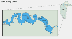
His lake design was the heart of the city. It had a central basin, shaped like a part of a circle. There were also western and eastern basins, which were more round. Beyond these were much larger, less regular western and eastern lakes.
Griffin carefully planned the lakes to line up with important landmarks in Canberra. The lakes stretched from east to west, dividing the city. A "land axis" went from Capital Hill, where the new Parliament House would be, across the central lake to the Australian War Memorial. This way, if you stood at Parliament House, you could see the War Memorial perfectly at the foot of Mount Ainslie.
The straight edge of the central lake was called the "water axis." It pointed towards Black Mountain, Canberra's highest point. Griffin also planned important roads like Commonwealth Avenue and Kings Avenue. These roads formed a special area called the Parliamentary Triangle. This area was meant to be the main part of Griffin's city plan.
Later, Scrivener and a government committee changed Griffin's design. They made the lake's shape more natural, using one large dam instead of many smaller ones. This new plan kept Griffin's three main lake basins.
Griffin talked with the government about these changes. He came to Canberra in 1913 and was put in charge of the city's design and construction. The plans changed a few more times, but the design of Lake Burley Griffin mostly stayed true to the committee's ideas. It was even protected by law in 1926. However, Griffin didn't get along well with the Australian government. By the time he left in 1920, not much building work had been done.
Challenges and Changes to the Plan
Building the new capital was very slow because of the Great Depression and then World War II. After the war, Canberra was often criticized. People said it looked more like a small village than a capital city. Its buildings seemed messy and unplanned.
During this time, the Molonglo River just flowed through a flood plain. The center of Griffin's planned city was mostly farmland. There were only small, temporary settlements. The lake and the Parliamentary Triangle, which were central to Griffin's vision, were just empty fields. A golf course, a racecourse, and a sports ground were all on this farmland. There was even a rubbish dump where the central lake basin was supposed to be.
In 1950, the largest part of the lake, the eastern lake, was removed from the plans. Officials thought there wouldn't be enough water to fill it. They also worried about flooding too much farmland.
By 1953, the western lake was also removed. It was replaced with a small, winding stream. Some officials thought Griffin's plan was too grand and expensive. They believed a smaller water feature would save money and land. However, engineering reports showed that the smaller plan would actually cost more and be harder to manage.
Many people were unhappy about these changes. They felt the decisions were made secretly. Some thought that powerful members of the Royal Canberra Golf Club, whose course was on the proposed western lake, influenced the changes.
A special parliamentary committee looked into the issue in 1954. They decided that the western lake was a good idea and should be put back into the plan. They found that removing it was a mistake.
Prime Minister Robert Menzies was very important in getting the lake built. At first, he didn't like the state of Canberra. But he later became a strong supporter of its development. He even changed ministers who weren't working fast enough on the city.
In 1958, a new group called the National Capital Development Commission (NCDC) was formed. Menzies gave them more power. The NCDC put the western lake back into the plans. It was officially approved in 1959. The NCDC also stopped a plan to build a bridge across the lake that would have gone against Griffin's original ideas.
A famous British architect, Sir William Holford, helped fine-tune Griffin's plans. He changed the shape of the central basin slightly, making it a bit more natural. This new design was closer to Scrivener's earlier modified plan.
Building the Lake
In 1958, engineers studied the river and the land to figure out how to build the dam. They found that the water level could be kept steady, even during floods.
Construction officially started in February 1959. Even though there were some delays with funding, once work began, it moved quickly. At its busiest, 400 to 500 people were working on the lake. John Overall, the head of the NCDC, promised Prime Minister Menzies that the lake would be finished in four years. He kept his promise!
Once the long debates about the design were over, most of the criticism about the lake stopped. Menzies strongly spoke out against those who still complained. Most critics thought the project was a waste of money. They felt the money should have been spent on important services across Australia. Others worried about problems like mosquitoes or harm to the environment.
Lakes, Islands, and Shoreline
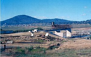
Work on Lake Burley Griffin began in 1960. First, all the plants and trees were cleared from the Molonglo River's flood plain. This included trees from the golf course and along the river. Sports fields and houses were also removed.
Workers dug up a lot of soil, about 382,000 cubic meters! This soil was used to create public parks and gardens, like Commonwealth Park. It was also used to build the six artificial islands in the lake. Springbank Island was named after a farm that used to be there. Spinnaker Island was made from soil dug out to create a sailing area. Stone from the digging was used to form Aspen Island near Kings Avenue Bridge.
The entire lake floor was dug to a depth of at least two meters. This was to make sure boats had enough room. It was also thought that this depth would prevent mosquitoes from breeding and weeds from growing.
Different types of lake edges were built:
- Concrete walls: These are strong, low walls found on the southern side of the Central Basin.
- Rock walls: These are made of rocks glued together. You can see them on the eastern side of the Central Basin and in much of the Eastern Basin.
- Sand and gravel beaches: These are perfect for lakeside fun and are mostly found on the western side of the lake.
- Rocky areas: These are steep, stable shores with water plants like bullrushes. You can see these in the Western Lake area.
Bridges
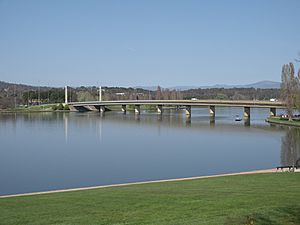
Lake Burley Griffin has three main crossings: Commonwealth Avenue Bridge, Kings Avenue Bridge, and a road over Scrivener Dam. The two main bridges were built before the lake was filled. They replaced older wooden bridges. These new bridges were designed to be tall enough for sailboats with high masts to pass underneath.
Testing for the bridges started in late 1959. Construction of Kings Avenue Bridge began in 1960, followed by Commonwealth Avenue Bridge in 1961. Luckily, Canberra was in a drought, so the ground stayed dry during construction.
Both bridges are made of concrete and steel. They have multiple lanes for cars. Kings Avenue Bridge has two lanes in each direction, and Commonwealth Avenue Bridge has three.
Kings Avenue Bridge opened on March 10, 1962. Prime Minister Menzies himself opened it. Commonwealth Avenue Bridge opened in 1963 without a big ceremony. Menzies called it "the finest building in the national capital."
The Dam

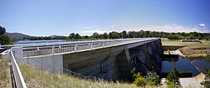
The dam that holds back the lake's water is called Scrivener Dam, named after Charles Scrivener. It was designed in Germany. About 55,000 cubic meters of concrete were used to build it. The dam is 33 meters high and 319 meters long. Its thickest part is 19.7 meters wide. The dam is built to handle very large floods, even ones that might happen only once every 5,000 years.
The dam has five large gates that control the water flow. These "fish-belly flap gates" are 30.5 meters wide and are operated by hydraulics. They allow very precise control of the water level. This means the banks don't have a large muddy area between high and low water levels. As of November 2010, all five gates have only been opened at the same time once, during a big flood in 1976.
Lady Denman Drive, a road on top of the dam wall, provides a third way to cross the lake. It has a road for cars and a path for bicycles. This was possible because the dam gates close by pushing up from below, which is different from older designs.
Filling the Lake
A long drought actually helped with the lake's construction. The gates on Scrivener Dam were closed on September 20, 1963. Prime Minister Menzies was sick and couldn't be there. For several months, there was no rain, and only small, mosquito-filled puddles appeared. But then the drought broke, and several days of heavy rain filled the lake. It reached its planned level on April 29, 1964.
On October 17, 1964, Menzies celebrated the lake's completion with an opening ceremony. There were sailboats and fireworks. Griffin's dream for the lake had finally come true after five decades! It cost about AUD5 million.
Some people suggested naming the lake after Menzies. But Menzies insisted it should be named after Griffin, who didn't have any other monuments in Canberra.
During very dry times, Lake Burley Griffin's water level can drop too low. When this happens, water can be released from Googong Dam upstream to top it up.
Googong Dam is on the Queanbeyan River, which flows into the Molonglo River. This dam, finished in 1979, is one of four dams that supply water to Canberra and Queanbeyan. Googong Dam can hold 124,500 million liters of water.


