Spud Island facts for kids

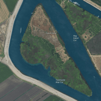
USGS aerial imagery of Spud Island, with McDonald Island to its west, Hog Island to its east, and Rindge Tract past Hog Island.
|
|
| Geography | |
|---|---|
| Location | Northern California |
| Coordinates | 38°00′27″N 121°27′26″W / 38.00750°N 121.45722°W |
| Adjacent bodies of water | Sacramento–San Joaquin River Delta |
| Highest elevation | 13 ft (4 m) |
| Administration | |
|
United States
|
|
| State | |
| County | San Joaquin |
Spud Island is a small piece of land located in the Sacramento–San Joaquin River Delta in Northern California. It is part of San Joaquin County. This island is known for its quiet location within the delta's waterways.
Discover Spud Island
Spud Island is a small island found in the huge network of rivers and channels called the Sacramento–San Joaquin River Delta. It is officially part of San Joaquin County, which is in the state of California.
Where is Spud Island Located?
You can find Spud Island at these exact coordinates: 38°00′27″N 121°27′26″W / 38.00750°N 121.45722°W. It sits within the delta, which is a very important area for water and wildlife in California.
How High is Spud Island?
In 1981, the United States Geological Survey (USGS) measured the height of Spud Island. They found that its elevation is about 13 ft (4.0 m) above sea level. This makes it a relatively low-lying island in the delta region.


