Spurgeon, Indiana facts for kids
Quick facts for kids
Spurgeon, Indiana
|
|
|---|---|
 |
|

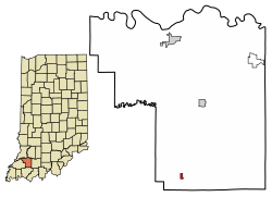
Location of Spurgeon in Pike County, Indiana.
|
|
| Country | United States |
| State | Indiana |
| County | Pike |
| Township | Monroe |
| Area | |
| • Total | 0.17 sq mi (0.45 km2) |
| • Land | 0.17 sq mi (0.45 km2) |
| • Water | 0.00 sq mi (0.00 km2) |
| Elevation | 489 ft (149 m) |
| Population
(2020)
|
|
| • Total | 172 |
| • Density | 982.86/sq mi (378.66/km2) |
| Time zone | UTC-6 (Central (CST)) |
| • Summer (DST) | UTC-5 (CDT) |
| ZIP code |
47584
|
| Area code(s) | 812 |
| FIPS code | 18-72440 |
| GNIS feature ID | 2397677 |
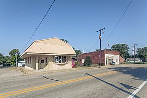
Spurgeon is a small town located in Pike County, in the state of Indiana in the United States. It's part of Monroe Township. In 2010, about 207 people lived there. Spurgeon is also part of the larger Jasper Micropolitan Statistical Area.
Contents
History of Spurgeon
Spurgeon was first known by a different name: Pleasantville. The town was officially planned out in 1860. Later, in 1867, a post office opened in the town, and that's when it started being called Spurgeon.
Geography of Spurgeon
According to information from 2010, the town of Spurgeon covers a total area of about 0.47 square kilometers (0.18 square miles). All of this area is land; there are no large bodies of water within the town limits.
Population and People in Spurgeon
This section looks at how many people live in Spurgeon and what the population is like.
Population Changes Over Time
The number of people living in Spurgeon has changed quite a bit over the years. Here's a quick look at the population counts from different years:
| Historical population | |||
|---|---|---|---|
| Census | Pop. | %± | |
| 1930 | 375 | — | |
| 1940 | 360 | −4.0% | |
| 1950 | 327 | −9.2% | |
| 1960 | 269 | −17.7% | |
| 1970 | 285 | 5.9% | |
| 1980 | 250 | −12.3% | |
| 1990 | 149 | −40.4% | |
| 2000 | 227 | 52.3% | |
| 2010 | 207 | −8.8% | |
| 2020 | 172 | −16.9% | |
| U.S. Decennial Census | |||
Spurgeon's Population in 2010
In 2010, a census (a count of the population) showed that 207 people lived in Spurgeon. These people lived in 78 different households, and 57 of these were families.
The town had about 1150 people per square mile (444 people per square kilometer). Most of the people living in Spurgeon were White (95.7%). A small number were from other racial backgrounds (3.9%), and 0.5% were from two or more races. About 3.4% of the population identified as Hispanic or Latino.
In terms of households:
- About 30.8% of households had children under 18 living with them.
- 60.3% were married couples living together.
- 7.7% had a female head of the household with no husband present.
- 5.1% had a male head of the household with no wife present.
- 26.9% were not families (like single people living alone).
The average household had 2.65 people, and the average family had 3.02 people. The average age of people in Spurgeon was 40.4 years. About 25.1% of residents were under 18, and 10.1% were 65 or older. The population was almost evenly split between males (51.2%) and females (48.8%).
Education in Spurgeon
Spurgeon is part of the Pike County School Corporation, which is the main school district for the county.
Years ago, before 1966, Spurgeon had its own high school. The school's colors were black and red, and their sports team mascot was the Cardinals. In 1966, this high school joined with Winslow High School. Later, in 1974, Winslow High School also merged with another school to become Pike Central High School.
See also

- You can find more information about Spurgeon (Indiana) for kids in Spanish here: Spurgeon (Indiana) para niños
 | Stephanie Wilson |
 | Charles Bolden |
 | Ronald McNair |
 | Frederick D. Gregory |

