
St. Croix River (Nova Scotia) facts for kids
Quick facts for kids St. Croix River |
|
|---|---|

St. Croix River (lower dam at St Croix)
|
|
| Country | Canada |
| Province | Nova Scotia |
| Physical characteristics | |
| Main source | Lake Panuke |
| River mouth | Confluence with the Avon River sea level |
| Length | 34 km (21 mi) |
| Basin features | |
| Progression | Avon River—Minas Basin—Bay of Fundy |
| Basin size | 1,368 km2 (528 sq mi) |
The St. Croix River is a river in Nova Scotia, Canada. It flows entirely within Hants and Halifax Counties. The river starts at Panuke Lake. People have used the river's water power for a long time. In the 1800s, water mills used the river's energy. Later, in the 1930s, three hydroelectric dams were built. These dams still work today, helping to make electricity.
The lower parts of the St. Croix River are affected by tides. There is a wide, flat area next to the river called a flood plain. Here, the river has cut through soft limestone rock. This rock now shows as white cliffs. The soil in this area is rich in calcium. It is home to a rare flower called the Rams Head Lady Slipper.
The Nova Scotia Government estimated that about 19,233 people lived near the St. Croix River in 2011.
Exploring the St. Croix River's Past
The St. Croix River and Panuke Lake were once very important travel routes. The Mi'kmaq people used them first. Later, European explorers and settlers also used these waterways. There is an area called the St. Croix Indian Reserve on the lake. No one lives there today.
European settlers, known as the Acadians, were the first to name the river. They called the whole area Pisiguit.
What Happened at the Battle of St. Croix (1750)?
The Battle at St. Croix was a fight between New England Rangers and the Mi'kmaq people. The year before, the British had lost a battle at Fort Logis, Grand Pre. To capture the Acadians who were involved, Governor Cornwallis sent John Gorham (military officer) to Piziquid. Gorham's job was to build Fort Edward (Nova Scotia) and hold the Acadians there.
After marching for two days from Fort Sackville (which is now Bedford), Gorham's group reached the St. Croix River. A battle started there with the Mi'kmaq. Gorham and his men took over a sawmill and two local Acadian homes for safety. More and more Mi'kmaq warriors arrived. So, Gorham sent a message to Fort Sackville asking for help. When reinforcements arrived, the battle ended.
After the Expulsion of the Acadians, new settlers from New England came to the area. They were called Planters. The Nova Scotia government began giving out large pieces of land starting in 1761.
Today, the St. Croix River is a popular spot for people who enjoy canoeing and kayaking. The lower floodplains are protected by walls called dykes and are used for farming. You can see the river's tidal bore, which is a wave that travels up the river with the tide, at Tidal View Farm.
Images for kids
-
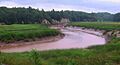
Meandering lower tidal reaches of the St. Croix

