St. Elizabeth, Missouri facts for kids
Quick facts for kids
St. Elizabeth, Missouri
|
|
|---|---|
|
Village
|
|

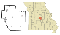
Location in Miller County and the state of Missouri
|
|
| Country | United States |
| State | Missouri |
| County | Miller |
| Founded | 1875 (as Charlestown) 1877 (as St. Elizabeth) |
| Area | |
| • Total | 1.04 sq mi (2.70 km2) |
| • Land | 1.04 sq mi (2.70 km2) |
| • Water | 0.00 sq mi (0.00 km2) |
| Elevation | 807 ft (246 m) |
| Population
(2020)
|
|
| • Total | 418 |
| • Density | 401.54/sq mi (155.04/km2) |
| Time zone | UTC-6 (Central (CST)) |
| • Summer (DST) | UTC-5 (CDT) |
| ZIP code |
65075
|
| Area code(s) | 573 |
| FIPS code | 29-64190 |
| GNIS feature ID | 2399162 |
St. Elizabeth or Saint Elizabeth is a small village in Miller County, Missouri, United States. In 2020, 418 people lived there. This was an increase from 336 people in 2010.
Contents
Discovering St. Elizabeth's Past
St. Elizabeth was first known as "Charlestown." It was officially mapped out in 1875. The town was named after Charley Holtschneider, who owned the land where it was built.
A post office opened in St. Elizabeth in 1877. The village got its current name from a local Roman Catholic church. This church was likely named after Elizabeth of Hungary, a very kind and generous saint.
Historic Boeckman Bridge
The Boeckman Bridge is an important landmark near St. Elizabeth. It was added to the National Register of Historic Places in 1979. This means it is a special place recognized for its history.
Exploring St. Elizabeth's Location
St. Elizabeth is located in the northeast part of Miller County. You can find it where Missouri routes 52 and E meet. The Osage River flows about two miles west of the village.
Nearby Towns and Rivers
Tuscumbia, the main town of the county, is about 14 miles to the west. You can reach it by taking Route 52. Meta, in nearby Osage County, is about 9 miles northeast, also along Route 52.
The village sits on top of a ridge. Water from the ridge flows west into Whalen Creek and east into Tavern Creek. Both of these creeks flow north and eventually join the Osage River.
Understanding St. Elizabeth's Population
| Historical population | |||
|---|---|---|---|
| Census | Pop. | %± | |
| 1880 | 15 | — | |
| 1950 | 59 | — | |
| 1960 | 57 | −3.4% | |
| 1970 | 287 | 403.5% | |
| 1980 | 312 | 8.7% | |
| 1990 | 257 | −17.6% | |
| 2000 | 297 | 15.6% | |
| 2010 | 336 | 13.1% | |
| 2020 | 418 | 24.4% | |
| U.S. Decennial Census | |||
Village Life in 2010
In 2010, there were 336 people living in St. Elizabeth. These people lived in 115 homes, and 84 of these were families. The village had about 329 people per square mile.
Most people living in the village were White (99.1%). About 1.8% of the population identified as Hispanic or Latino.
Many homes (37.4%) had children under 18 living there. More than half (56.5%) were married couples. Some homes (13.0%) had a female head of household without a husband. A small number (3.5%) had a male head of household without a wife. About 27.0% of homes were not families.
Almost half of the homes (26.1%) had only one person living in them. About 18.3% of homes had someone 65 years or older living alone. On average, each home had 2.63 people, and each family had 3.17 people.
The average age of people in the village was 39.5 years. About 28.9% of residents were under 18 years old. About 23.5% were 65 years or older. The village had slightly more females (55.1%) than males (44.9%).
See also
 In Spanish: St. Elizabeth (Misuri) para niños
 | Laphonza Butler |
 | Daisy Bates |
 | Elizabeth Piper Ensley |

