St. Johns, Maricopa County, Arizona facts for kids
Quick facts for kids
St. Johns, Arizona
|
|
|---|---|

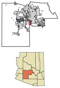
Location in Maricopa County, Arizona
|
|
| Country | United States |
| State | Arizona |
| County | Maricopa |
| Area | |
| • Total | 2.28 sq mi (5.9 km2) |
| • Land | 2.28 sq mi (5.9 km2) |
| • Water | 0.0 sq mi (0 km2) |
| Elevation | 1,006 ft (307 m) |
| Population
(2020)
|
|
| • Total | 690 |
| • Density | 302.5/sq mi (116.8/km2) |
| Time zone | UTC-7 (MST (no DST)) |
| ZIP code |
85339 (Laveen)
|
| FIPS code | 04-62362 |
St. Johns is a small community in Maricopa County, Arizona, United States. It is known as a census-designated place (CDP). This means it is an area that looks like a town but does not have its own local government. St. Johns is located within the Gila River Indian Community.
In 2020, about 690 people lived in St. Johns. This number grew from 476 people in 2010.
Geography of St. Johns
St. Johns is located on the south side of the Phoenix metropolitan area. It sits on the northeast side of the Gila River valley.
To the southeast, St. Johns is next to the communities of Komatke and Gila Crossing. The center of Downtown Phoenix is about 15 miles (24 kilometers) to the northeast.
People of St. Johns
In 2010, the community had 476 residents. This means there were about 208.7 people living in each square mile.
Most of the people living in St. Johns are Native American. About 95% of the population identified as Native American in 2010. A small number of residents were White or Black. About 4% of the people were of Hispanic or Latino background.
See also
 In Spanish: St. Johns (condado de Maricopa) para niños
 | Stephanie Wilson |
 | Charles Bolden |
 | Ronald McNair |
 | Frederick D. Gregory |


