
St. Matthew Island facts for kids

View of Cape Upright, St. Matthew Island
|
|
 |
|
| Geography | |
|---|---|
| Location | Bering Sea |
| Coordinates | 60°24′31″N 172°43′12″W / 60.40861°N 172.72000°W |
| Archipelago | none |
| Area | 137.857 sq mi (357.05 km2) |
| Length | 31.7 mi (51 km) |
| Highest elevation | 1,476 ft (449.9 m) |
| Administration | |
|
United States
|
|
| State | Alaska |
| Demographics | |
| Population | Uninhabited |

.svg)
St. Matthew Island (which means Ostrof Svyatovo Matveya in Russian) is a faraway island in the Bering Sea. It is part of Alaska, a state in the United States. The island is about 183 miles (295 km) west-northwest of Nunivak Island.
This entire island is a protected area. It is part of the Bering Sea unit of the Alaska Maritime National Wildlife Refuge. This means its amazing natural beauty and wildlife are kept safe.
St. Matthew Island covers about 137.857 square miles (357.05 km2). This makes it the 43rd largest island in the United States. Its most southern tip is called Cape Upright. This cape has tall cliffs that are over 1,000 feet (300 m) high. Similar high cliffs are found at Glory of Russia Cape in the north. The highest point on the island is 1,476 feet (450 m) above sea level. This high point is located south of the island's center.
A smaller island called Hall Island is located off St. Matthew Island's northwest side. The water between these two islands is called Sarichef Strait. It is about 3.1 miles (5 km) wide. There is also a small rocky island called Pinnacle Rock. It lies about 9.3 miles (15 km) south of St. Matthew Island.
The United States Coast Guard used to have a station on the island. This station was for a navigation system called LORAN. It was used during the 1940s.
Contents
Island Weather and Rocks
The weather around the Bering Sea is often windy, cool, and cloudy. St. Matthew Island gets about 15.3 inches (39 cm) of rain or snow each year. The average temperature is about 37.8°F (3.2°C).
The island's rocks are mostly volcanic rocks. These rocks formed a very long time ago, during the Late Cretaceous period. The soil on the island is a type that stays frozen for most of the year.
People on the Island
No one lives on St. Matthew Island today. But there was an attempt to settle there in 1809. A Russian group tried to set up an outpost.
Even though no one lives on the island, its beaches have a problem. A trip to the island in 2013 found a lot of plastic trash. Much of this trash came from the fishing industry.
Island Mammals
Today, the only mammals that live on St. Matthew Island are Arctic foxes and small insular voles. Sometimes, polar bears visit the island. They travel there on floating ice. St. Matthew Island is the most southern place where polar bears are usually found in the Bering Sea.

In 1944, the United States Coast Guard brought 29 reindeer to the island. They wanted the reindeer to be a food source in case of an emergency. The Coast Guard left the island a few years later, but the reindeer stayed.
The reindeer population grew very quickly. By 1963, there were about 6,000 reindeer on the island! But then, in the next two years, almost all of them died. Only 42 reindeer were left. Scientists studied this and found that there wasn't enough food for so many reindeer. A very cold winter in 1963–64 also made things worse. By the 1980s, all the reindeer on the island had died out.
This event is often used as an example of overpopulation. Ecologists, who study how living things interact with their environment, use the St. Matthew Island reindeer story to show what happens when a population grows too big for its home.
Island Fish
St. Matthew Island has two main lakes: North Lake and Big Lake. These lakes have more types of fish than other nearby islands. There are at least 5 different kinds of fish living there.
Island Lichens
Lichens are like a mix of fungi and algae. Scientists studied them on St. Matthew Island in the 1990s. They wanted to find out what kinds of lichens were there and where they grew. This was important because lichens are a food source for animals like caribou. They also help scientists understand air quality.
The plants on the island are mostly tundra plants. This means they are suited for cold, windy places. Many of the lichens found on the island are types that grow in cold, northern areas. Scientists found a lot of different lichens, which was interesting. This rich variety of lichens was linked to the reindeer disappearing from the island.
Images for kids
-
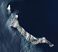
Satellite view of St. Matthew Island
-
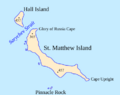
Map of St. Matthew Island and Hall Island
See also
 In Spanish: Isla de San Mateo para niños
