St. Pauls, North Carolina facts for kids
Quick facts for kids
St. Pauls, North Carolina
|
|
|---|---|
|
Town
|
|

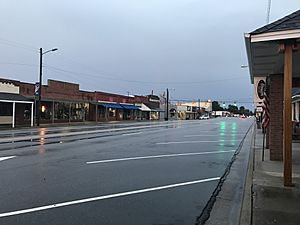
A view of Broad Street in St. Pauls
|
|
| Nickname(s):
Small Town With a Big Heart
|
|
| Motto(s):
"Window of Economic Development"
|
|
| Country | United States |
| State | North Carolina |
| County | Robeson |
| Incorporated | 1909 |
| Named for | Local church |
| Area | |
| • Total | 1.63 sq mi (4.22 km2) |
| • Land | 1.63 sq mi (4.22 km2) |
| • Water | 0.00 sq mi (0.00 km2) |
| Elevation | 167 ft (51 m) |
| Population
(2020)
|
|
| • Total | 2,045 |
| • Density | 1,256.14/sq mi (485.08/km2) |
| Time zone | UTC-5 (Eastern (EST)) |
| • Summer (DST) | UTC-4 (EDT) |
| ZIP code |
28384
|
| Area codes | 910, 472 |
| FIPS code | 37-58720 |
| GNIS feature ID | 2407393 |
| Website | Town of St. Pauls |
St. Pauls is a town located in Robeson County, North Carolina, in the United States. In 2020, about 2,045 people lived there.
Contents
History of St. Pauls
The town of St. Pauls grew around the St. Pauls Presbyterian Church. This church was built on land given by William Davis in 1799. At first, St. Pauls was very small. It had only the church, Davis's home, a post office, and a place for horses called a livery stable. The stable was located on the main road between Fayetteville and Lumberton.
Growth and Industry in St. Pauls
St. Pauls started to grow more quickly after the Robeson Institute was built. This school taught both boys and girls from the northern part of Robeson County. The town also grew when the Virginia and Carolina Southern Railway came through. This helped St. Pauls become a major center for making textiles, which are fabrics and clothes.
In the early 1900s, three cotton mills were built in St. Pauls. These mills made a lot of fabric. They had good times and bad times. By 1943, the Burlington Mills Corporation took over the mills. The mills brought a lot of money to the town through taxes. Because of this, the town could offer free water, sewer, and trash services to its residents for a while.
Changes in the Textile Industry
Most of the mills in St. Pauls closed in the 1990s. This happened because the textile industry started moving from the American South to other countries. In 2001, two yarn factories closed, and over 500 people lost their jobs. For many years, it was hard to find new jobs in the town.
However, things started to get better in the 2010s. St. Pauls was able to attract new businesses and investments. This helped the town's job market grow again.
Historic Places in St. Pauls
Two important historical places in St. Pauls are listed on the National Register of Historic Places. These are the Gilmore-Patterson Farm and the Kenneth McKinnon House. They are protected because of their historical value.
Geography of St. Pauls
St. Pauls is a small town. It covers about 1.3 square miles (3.4 square kilometers) of land. There is no water area within the town limits.
Population of St. Pauls
The number of people living in St. Pauls has changed over the years. Here is a look at the population from different U.S. Census reports:
| Historical population | |||
|---|---|---|---|
| Census | Pop. | %± | |
| 1910 | 419 | — | |
| 1920 | 1,147 | 173.7% | |
| 1930 | 2,080 | 81.3% | |
| 1940 | 1,923 | −7.5% | |
| 1950 | 2,251 | 17.1% | |
| 1960 | 2,249 | −0.1% | |
| 1970 | 2,011 | −10.6% | |
| 1980 | 1,639 | −18.5% | |
| 1990 | 1,992 | 21.5% | |
| 2000 | 2,137 | 7.3% | |
| 2010 | 2,035 | −4.8% | |
| 2020 | 2,045 | 0.5% | |
| U.S. Decennial Census | |||
People Living in St. Pauls (2020)
The 2020 United States census showed that 2,045 people lived in St. Pauls. There were 884 households and 463 families. The population is made up of people from different backgrounds:
| Race | Number of People | Percentage |
|---|---|---|
| White (not Hispanic) | 865 | 42.3% |
| Black or African American (not Hispanic) | 346 | 16.92% |
| Native American | 118 | 5.77% |
| Asian | 8 | 0.39% |
| Pacific Islander | 1 | 0.05% |
| Other/Mixed | 77 | 3.77% |
| Hispanic or Latino | 630 | 30.81% |
People Living in St. Pauls (2010)
In the 2010 United States Census, there were 2,035 people living in St. Pauls.
- About 48.9% were White.
- About 18.5% were Black.
- About 5.4% were Native American.
- About 0.2% were Asian.
- About 0.1% were Pacific Islander.
- About 0.1% were from some other race.
- About 1.7% were from two or more races.
- About 25.1% of the people were Hispanic or Latino.
Sports in St. Pauls
The Carolina Raging Wolves is a women's football team. They play their games at St. Pauls High School, which is located in the town.
Famous People from St. Pauls
- John Beard is a news anchor who was born in St. Pauls.
- Judy Clay was a famous soul and gospel singer. She was also born in St. Pauls.
See also
 In Spanish: St. Pauls para niños
 | Frances Mary Albrier |
 | Whitney Young |
 | Muhammad Ali |


