St Andrew's Cross, Glasgow facts for kids
Quick facts for kids St Andrew's Cross
|
|
|---|---|
| OS grid reference | NS584634 |
| Council area | |
| Lieutenancy area |
|
| Country | Scotland |
| Sovereign state | United Kingdom |
| Post town | GLASGOW |
| Postcode district | G5, G41, G42 |
| Dialling code | 0141 |
| Ambulance | Scottish |
| EU Parliament | Scotland |
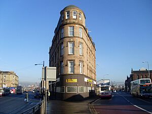
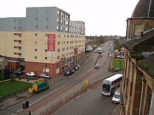
St Andrew's Cross, also known as Eglinton Toll, is a busy road junction in the south side of Glasgow, Scotland. It was first built in the early 1800s. This area used to have many buildings, like a power station and a cinema. However, these buildings are no longer there. Since 1946, the roads at the junction were changed so they no longer cross each other directly for cars.
What is St Andrew's Cross?
This junction has two main roads that run north and south. They meet, but cars cannot drive straight through from one to the other. This change happened in 1946 to make traffic flow better.
The road on the west side is called Eglinton Street. It starts in Laurieston and becomes Pollokshaws Road as it goes towards Strathbungo. The road on the east side is Pollokshaws Road from Laurieston, but it changes to Victoria Road when it enters Govanhill. Maxwell Road also joins the junction from the west, coming from Pollokshields. However, this road is also blocked for cars at the junction.
The buildings around St Andrew's Cross have three different postcode areas: G5, G41, and G42. This shows that the junction is a meeting point for different parts of the city. It doesn't fully belong to just one area.
History of St Andrew's Cross
The junction got its name from Saint Andrew, the patron saint of Scotland. This is because the way the roads meet looks like the "X" shape of the Scottish flag.
The other name, Eglinton Toll, comes from the area being the southern entrance to Port Eglinton. This was an industrial area between Pollokshields and Tradeston. It was planned to be a dock area for a waterway called the Glasgow, Paisley and Johnstone Canal. This canal was started in the early 1800s by Hugh Montgomerie, 12th Earl of Eglinton. It was meant to go all the way to the coast of Ayrshire, but it was never fully finished. In the 1880s, a railway line took its place. Today, these are the Paisley Canal line and the Inverclyde/Ayrshire train lines.
In 2010, a new part of the M74 motorway was built through the Port Eglinton area. It runs on a high bridge supported by large pillars.
Many local bus routes use the roads around St Andrew's Cross. In the past, trams also used these roads. The area was a popular spot for bus drivers to change shifts because it was close to the Larkfield bus depot. The Star Bar pub and diner, known for its cheap meals, was a favorite place for these drivers. This practice became less common after the bus depot closed in 2014. A new depot opened later that year, a bit further east.
The cross also used to have a power station, a gasworks, and a tram depot from the 1890s. There was also a cinema and a big dance hall called The Plaza Ballroom. The Plaza Ballroom was torn down and new apartments were built there. Some of the original red sandstone from the old building was used in the new apartments. Part of the old power station building still stands, but it is now empty and unused. It was later used by the local council as a printing works.
Today, there are new homes being built nearby. These are on Barrland Street and where the cinema, gasworks, and old bus depot used to be. Besides many buses, the Pollokshields East railway station is a short walk to the south-east. Close by are the Tramway (arts centre), which is in the old tram depot buildings, the main building for Scottish Ballet, and the Guru Granth Sahib Sikh Sabha, a large Sikh temple.
 | Victor J. Glover |
 | Yvonne Cagle |
 | Jeanette Epps |
 | Bernard A. Harris Jr. |


