St Martin-in-the-Fields (parish) facts for kids
| St Martin-in-the-Fields | |
 |
|
| Geography | |
| Status | Civil parish |
| 1881/1921 area | 286 acres (1.16 km2) |
| HQ | Vestry Hall, St Martin's Place |
| History | |
| Origin | Ancient parish |
| Abolished | 1922 |
| Succeeded by | City of Westminster (parish) |
Quick facts for kids Demography |
|
|---|---|
| 1881 population | 17,508 |
| 1901 population | 12,980 |
| 1921 population | 10,666 |
| Politics | |
| Governance | St Martin in the Fields Vestry |
St Martin-in-the-Fields was a special area, like a neighborhood, in London, England. It was named after a famous church called St Martin-in-the-Fields. This area was part of a bigger region known as the Liberty of Westminster. It even included important places like Buckingham Palace and St James's Palace within its borders.
How St Martin-in-the-Fields Changed
St Martin-in-the-Fields started as a very old type of local area called an "ancient parish." In 1542, it grew bigger. It gained land between the church of St Clement Danes and the Palace of Westminster. This land came from another parish called Westminster St Margaret.
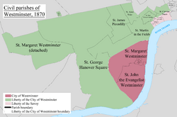
Originally, the St Martin-in-the-Fields area was much larger. It included four other areas that later became their own separate parishes. You can see the original area in green on the map. These four new parishes were:
| St Paul Covent Garden (also known as Covent Garden) | 1645 |
| Westminster St James (later called St James's) | 1685 |
| St Anne Soho (also known as Soho) | 1687 |
| St George Hanover Square (included areas like Mayfair and later Belgravia and Pimlico) | 1724 |
Helping People in Need
For a long time, St Martin-in-the-Fields was in charge of helping people who were poor or needed support. This was part of the "poor law" system. In 1868, it joined with other areas to form the Strand Poor Law Union. This group worked together to provide help.
Changes in Local Government
In 1855, the local leaders of the parish, called the "vestry," became a formal local authority. This meant they had more power to manage the area. They worked under a larger group called the Metropolitan Board of Works.
Because the parish had more than 2,000 "ratepayers" (people who paid local taxes), it was divided into three sections called "wards." Each ward elected people to the vestry.
- Ward No. 1 elected 12 members.
- Ward No. 2 elected 12 members.
- Ward No. 3 elected 12 members.
Later, in 1896, the population had grown even more. So, the vestry changed the wards again. The new wards were:
- Park (elected 15 members)
- Long Acre (elected 12 members)
- Embankment (elected 9 members)
In 1889, St Martin-in-the-Fields became part of the new County of London. Then, in 1900, it became part of the Metropolitan Borough of Westminster. The old vestry was replaced by the Westminster City Council. The building where the vestry met became the Westminster City Hall.
The civil parish of St Martin-in-the-Fields officially ended in 1922.
 | DeHart Hubbard |
 | Wilma Rudolph |
 | Jesse Owens |
 | Jackie Joyner-Kersee |
 | Major Taylor |

