
Statenville, Georgia facts for kids
Quick facts for kids
Statenville, Georgia
|
|
|---|---|

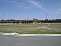
Echols County Courthouse in Statenville
|
|

Statenville, Georgia
Location in Georgia (U.S. state)

Statenville, Georgia
Location in the United States
|
|
| Country | United States |
| State | Georgia |
| County | Echols |
| Area | |
| • Total | 4.6 sq mi (12.0 km2) |
| • Land | 4.6 sq mi (12.0 km2) |
| • Water | 0 sq mi (0.0 km2) |
| Elevation | 138 ft (42 m) |
| Population
(2010)
|
|
| • Total | 1,040 |
| • Density | 225/sq mi (87.0/km2) |
| Time zone | UTC-5 (Eastern (EST)) |
| • Summer (DST) | UTC-4 (EDT) |
| ZIP code |
31648
|
| Area code(s) | 229 |
| FIPS code | 13-73200 |
| GNIS feature ID | 356558 |
Statenville is a small community in Georgia, United States. It is known as an unincorporated community. This means it does not have its own local city government.
Statenville is also the county seat of Echols County. This means it is where the main government offices for the county are located. In 2010, about 1,040 people lived there. The area's ZIP code is 31648, and its phone area code is 229.
Contents
History of Statenville
How Statenville Got Its Name
The area that is now Statenville was first called Troublesome. It started as a small settlement in the 1850s. This community grew around a place where people could easily cross the Alapaha River.
In 1858, Echols County was created. Troublesome was chosen to be the county seat. At this time, its name was changed to Statenville. The town was named after James Watson Staten.
Changes to the Town's Status
When the town was officially recognized in 1859, its name was accidentally spelled "Statesville." In 1965, the state of Georgia corrected this mistake. The official documents were changed to show the correct name, "Statenville."
Later, in 1995, a new state law was passed. This law removed the official city status for many towns in Georgia. These were towns that no longer had active local governments. Because of this, Statenville lost its city charter. This made Echols County one of only two counties in Georgia without any official cities.
In July 2008, people in Statenville voted on an important change. They voted to combine the community with Echols County. The idea passed with 639 votes for and 245 against. This means Statenville is now fully part of the county's government structure.
Geography and Location
Where Statenville is Located
Statenville is found in the western part of Echols County. It is located just east of the Alapaha River. This river is an important natural feature nearby.
Roads and Travel
U.S. Route 129 goes right through Statenville. This road connects Statenville to other places.
- North: It goes about 27 miles (43 km) to Lakeland.
- South: It goes about 6 miles (10 km) to the Florida border.
- Further South: It goes about 14 miles (23 km) to Jasper, Florida.
Another important road, Georgia State Route 94, crosses U.S. Route 129 in the middle of Statenville.
- East: It goes about 28 miles (45 km) to Fargo.
- Northwest: It goes about 18 miles (29 km) to Valdosta.
Size of the Area
According to the U.S. Census Bureau, the area of Statenville is about 11.96 square kilometers (4.62 square miles). All of this area is land, with no large bodies of water within its boundaries.
Education in Statenville
Echols County Schools
The Echols County School District is responsible for education in the area. This district has two schools. There are about 40 full-time teachers working in these schools. Over 700 students attend classes in the district.
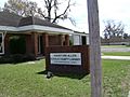
Hansford Allen Echols County Library
The South Georgia Regional Library system includes the Hansford Allen Echols County Library. This library is named after Handsford Allen. He was a farmer who worked with timber and turpentine. He gave money to help start the library.
The Hansford Allen Echols County Library is the smallest library in its system. It first opened its doors on July 19, 1992. The state of Georgia provided the money to build it. Before this library was built, the community's library was in other places. It was once in a Methodist church. Later, it was located in the school district superintendent's office at the courthouse.
-
Echols County Schools
-
Hansford Allen Echols County Library


Population and People
Population Changes Over Time
| Historical population | |||
|---|---|---|---|
| Census | Pop. | %± | |
| 2010 | 1,040 | — | |
| U.S. Decennial Census 1850-1870 1870-1880 1890-1910 1920-1930 1940 1950 1960 1970 1980 1990 2000 2010 |
|||
Statenville was listed as a "census-designated place" (CDP) in the 2010 U.S. Census. A CDP is a special area that the U.S. Census Bureau defines for gathering population data. After 2008, Statenville combined with the county. Because of this, it was no longer listed as a separate CDP in later censuses.
Diversity of the Community
The table below shows the different groups of people who lived in Statenville in 2010. The U.S. census counts Hispanic/Latino as an ethnic group. This means people of any race can be Hispanic or Latino.
| Race / Ethnicity (NH = Non-Hispanic) | Pop 2010 | % 2010 |
|---|---|---|
| White alone (NH) | 560 | 53.85% |
| Black or African American alone (NH) | 121 | 11.63% |
| Native American or Alaska Native alone (NH) | 22 | 2.12% |
| Asian alone (NH) | 9 | 0.87% |
| Pacific Islander alone (NH) | 1 | 0.10% |
| Some Other Race alone (NH) | 0 | 0.00% |
| Mixed Race/Multi-Racial (NH) | 23 | 2.21% |
| Hispanic or Latino (any race) | 304 | 29.23% |
| Total | 1,040 | 100.00% |
See also
 In Spanish: Statenville para niños
