Statistical regions of Slovenia facts for kids
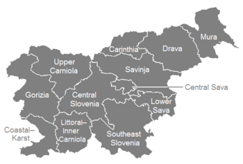
Slovenia is divided into 12 special areas called statistical regions. These regions help the government and people who collect facts and figures (statistics) understand the country better. They were created in May 2005.
These 12 regions are then grouped into two bigger parts: Eastern Slovenia (called Vzhodna Slovenija in Slovenian) and Western Slovenia (called Zahodna Slovenija in Slovenian).
Some of these regions have changed their names over time. For example, in 2015, the "Spodnjeposavska" region became "Posavska". Also, "Notranjsko-kraška" changed its name to "Primorsko-notranjska".
Slovenia's Statistical Regions
Here is a list of all 12 statistical regions in Slovenia:
| Map | Statistical regions | ||||
|---|---|---|---|---|---|
|
|
English name | Slovenian name | Code | Largest city | |
 |
Eastern Slovenia | ||||
| Mura | Pomurska | SI011 | Murska Sobota | ||
| Drava | Podravska | SI012 | Maribor | ||
| Carinthia | Koroška | SI013 | Slovenj Gradec | ||
| Savinja | Savinjska | SI014 | Celje | ||
| Central Sava | Zasavska | SI015 | Trbovlje | ||
| Lower Sava | Posavska | SI016 | Krško | ||
| Southeast Slovenia | Jugovzhodna Slovenija | SI017 | Novo Mesto | ||
| Inner Carniola–Karst | Notranjsko-kraška | SI018 | Postojna | ||
| Western Slovenia | |||||
| Central Slovenia | Osrednjeslovenska | SI021 | Ljubljana | ||
| Upper Carniola | Gorenjska | SI022 | Kranj | ||
| Gorizia | Goriška | SI023 | Nova Gorica | ||
| Coastal–Karst | Obalno-kraška | SI024 | Koper | ||
See also
 In Spanish: Regiones estadísticas de Eslovenia para niños
Black History Month on Kiddle
Famous African-American Athletes:
 | Jackie Robinson |
 | Jack Johnson |
 | Althea Gibson |
 | Arthur Ashe |
 | Muhammad Ali |

All content from Kiddle encyclopedia articles (including the article images and facts) can be freely used under Attribution-ShareAlike license, unless stated otherwise. Cite this article:
Statistical regions of Slovenia Facts for Kids. Kiddle Encyclopedia.
