Stearns, Kentucky facts for kids
Quick facts for kids
Stearns, Kentucky
|
|
|---|---|

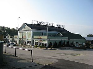
Stearns in 2010
|
|

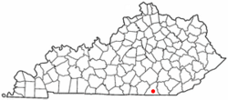
Location in Kentucky
|
|
| Country | United States |
| State | Kentucky |
| County | McCreary |
| Area | |
| • Total | 4.05 sq mi (10.50 km2) |
| • Land | 4.02 sq mi (10.41 km2) |
| • Water | 0.03 sq mi (0.09 km2) |
| Elevation | 1,319 ft (402 m) |
| Population
(2020)
|
|
| • Total | 1,365 |
| • Density | 339.55/sq mi (131.11/km2) |
| Time zone | UTC-5 (Eastern (EST)) |
| • Summer (DST) | UTC-4 (EDT) |
| ZIP code |
42647
|
| Area code(s) | 606 |
| FIPS code | 21-73362 |
| GNIS feature ID | 2402896 |
Stearns is a small community in McCreary County, Kentucky, United States. It is known as a census-designated place (CDP). This means it is an area that looks like a town but doesn't have its own local government. In 2020, about 1,365 people lived here. Stearns was founded by a person named Justus Smith Stearns.
Contents
Geography of Stearns
Stearns is located in the southern part of McCreary County. To its north, you'll find Whitley City, which is the main town of the county. To the south is another community called Pine Knot. Part of the community of Revelo is also located near the southern border of Stearns.
Roads and Travel
U.S. Route 27 runs along the eastern side of Stearns. This road can take you north about 31 miles (50 km) to Somerset. If you go south on US 27, you'll reach Oneida, Tennessee, about 16 miles (26 km) away. Kentucky Route 92 goes through the middle of Stearns. Traveling west on KY 92 leads to Monticello, about 29 miles (47 km) away. If you go east on KY 92, it joins US 27 south to Pine Knot, then turns east towards Williamsburg.
Land and Water
Stearns covers an area of about 4.05 square miles (10.50 square kilometers). Most of this area is land. Only a small part, about 0.03 square miles (0.09 square kilometers), is water. The western side of Stearns has small streams that flow into Roaring Paunch Creek. This creek then flows into the South Fork of the Cumberland River. On the eastern side, streams flow into Marsh Creek, which goes north to the main Cumberland River.
Climate in Stearns
Stearns has a type of weather called a humid subtropical climate. This means it has hot, wet summers and winters that are usually mild or cool. The hottest temperature ever recorded in Stearns was 108°F (42°C) on July 12, 1936. The coldest temperature ever recorded was -24°F (-31°C) on January 21, 1985.
Population and People
| Historical population | |||
|---|---|---|---|
| Census | Pop. | %± | |
| 1980 | 1,557 | — | |
| 1990 | 1,550 | −0.4% | |
| 2000 | 1,586 | 2.3% | |
| 2010 | 1,416 | −10.7% | |
| 2020 | 1,365 | −3.6% | |
| U.S. Decennial Census | |||
In 2000, there were 1,586 people living in Stearns. Most of the people living there were White. A small number were Native American or from other backgrounds. About 30.7% of homes had children under 18 living in them. The average age of people in Stearns was 38 years old.
Education
Stearns is home to two important schools. These are McCreary Central High School and McCreary Middle School.
See also
 In Spanish: Stearns (Kentucky) para niños

