
Steinschartenkopf facts for kids
Quick facts for kids Steinschartenkopf |
|
|---|---|

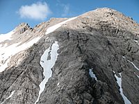
The Steinschartenkopf from the south between the Kleiner Steinscharte and Socktalscharte notches
|
|
| Highest point | |
| Elevation | 2615 |
| Prominence | 74 m ↓ Kleine Steinscharte |
| Isolation | 0.4 km → Hohes Licht |
| Geography | |
|
Lua error in Module:Location_map at line 420: attempt to index field 'wikibase' (a nil value).
|
|
| Parent range | Central Ridge, Allgäu Alps |
| Climbing | |
| Normal route | along the Heilbronn Way |
The Steinschartenkopf is a tall mountain in the Allgäu Alps. It stands at 2,615 metres (8,579 ft) (about 8,580 feet) high. This makes it one of the highest peaks in the area.
This mountain is located in Tyrol, Austria. It is just north of another mountain called Hohes Licht. The Steinschartenkopf is actually the sixth tallest mountain in the entire Allgäu Alps.
A very famous hiking path, the Heilbronn Way (also known as Heilbronner Weg), goes right over the top of the Steinschartenkopf. In fact, the summit of Steinschartenkopf is the highest point along this entire trail!
Exploring the Steinschartenkopf
The Steinschartenkopf is a popular spot for hikers. Its location on the Heilbronn Way makes it a key part of many mountain adventures. This trail is well-known for its amazing views and challenging sections.
The Heilbronn Way
The Heilbronn Way is a famous high-alpine trail. It connects several peaks in the Allgäu Alps. Hikers often use ladders and fixed ropes to cross difficult parts. The path offers stunning views of the surrounding mountains.
What to Expect on the Trail
When you hike the Heilbronn Way, you will find yourself high up in the mountains. The trail can be steep and rocky in places. It is important to be prepared with good gear. Many people enjoy the adventure and the beautiful scenery.
Gallery
-
Steinschartenkopf seen from the Bockkarkopf mountain -
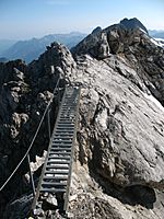
A part of the Heilbronn Way, crossing the Steinschartenkopf summit


