Stinesville, Indiana facts for kids
Quick facts for kids
Stinesville, Indiana
|
|
|---|---|

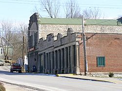
Downtown Stinesville
|
|

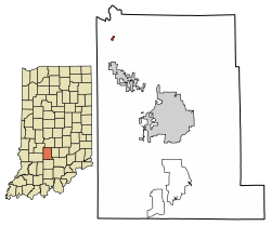
Location in Monroe County, Indiana
|
|
| Country | United States |
| State | Indiana |
| County | Monroe |
| Township | Bean Blossom |
| Area | |
| • Total | 0.11 sq mi (0.29 km2) |
| • Land | 0.11 sq mi (0.29 km2) |
| • Water | 0.00 sq mi (0.00 km2) |
| Elevation | 630 ft (190 m) |
| Population
(2020)
|
|
| • Total | 203 |
| • Density | 1,828.83/sq mi (707.04/km2) |
| Time zone | UTC-5 (Eastern (EST)) |
| • Summer (DST) | UTC-4 (EDT) |
| ZIP code |
47464
|
| Area code(s) | 812, 930 |
| FIPS code | 18-73232 |
| GNIS feature ID | 2397683 |
Stinesville is a small town located in Monroe County, Indiana. It is part of Bean Blossom Township. In 2020, about 203 people lived there. Stinesville is also part of the larger Bloomington Metropolitan Statistical Area.
History of Stinesville
Stinesville was officially planned and marked out in 1855. This happened when the New Albany and Salem Railroad line reached the area. The town was named after Eusebius Stine. He was the person who originally owned the land where the town was built. A post office has been open in Stinesville since 1860.
In 1995, the Stinesville Commercial Historic District was added to the National Register of Historic Places. This means it is a special area recognized for its important history.
Geography and Location
Stinesville is in the northwest part of Monroe County. It is about 5 miles (8 km) north of Ellettsville. The town is also about 14 miles (23 km) northwest of Bloomington. Bloomington is the main city and county seat of Monroe County.
The town covers a total area of 0.11 square miles (0.29 square kilometers). All of this area is land. Stinesville is located on the east side of Jacks Defeat Creek. This creek flows northeast for about 1 mile (1.6 km). It then joins Beanblossom Creek. Beanblossom Creek flows northwest into the White River.
Population and People
| Historical population | |||
|---|---|---|---|
| Census | Pop. | %± | |
| 1870 | 140 | — | |
| 1900 | 288 | — | |
| 1910 | 497 | 72.6% | |
| 1920 | 299 | −39.8% | |
| 1930 | 310 | 3.7% | |
| 1940 | 337 | 8.7% | |
| 1950 | 355 | 5.3% | |
| 1960 | 288 | −18.9% | |
| 1970 | 291 | 1.0% | |
| 1980 | 227 | −22.0% | |
| 1990 | 204 | −10.1% | |
| 2000 | 194 | −4.9% | |
| 2010 | 198 | 2.1% | |
| 2020 | 203 | 2.5% | |
| U.S. Decennial Census | |||
In the year 2000, there were 194 people living in Stinesville. These people lived in 67 different homes. About 48 of these were families. The population density was about 1,784 people per square mile (689 people per square kilometer).
Most of the people living in Stinesville were White (95.88%). A smaller number were Asian (2.58%). About 1.55% of the population were from two or more racial backgrounds.
In 2000, about 32.8% of homes had children under 18 living there. More than half (55.2%) were married couples. About 11.9% of homes had a female head of household without a husband. About 25.4% of all homes were individuals living alone. This included 16.4% of people aged 65 or older.
The average household had 2.90 people. The average family had 3.35 people. The median age in the town was 36 years old. About 30.9% of the population was under 18. About 10.3% were 65 years or older.
The median income for a household in Stinesville was $31,875. For families, the median income was $36,875. The average income per person in the town was $11,411. Very few families (none) and only 1.0% of the total population lived below the poverty line.
See also
 In Spanish: Stinesville (Indiana) para niños
 | Selma Burke |
 | Pauline Powell Burns |
 | Frederick J. Brown |
 | Robert Blackburn |

