Stockton, Maryland facts for kids
Quick facts for kids
Stockton, Maryland
|
|
|---|---|

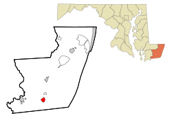
Location of Stockton, Maryland
|
|
| Country | United States |
| State | Maryland |
| County | Worcester |
| Area | |
| • Total | 1.71 sq mi (4.42 km2) |
| • Land | 1.70 sq mi (4.41 km2) |
| • Water | 0.00 sq mi (0.01 km2) |
| Elevation | 33 ft (10 m) |
| Population
(2020)
|
|
| • Total | 91 |
| • Density | 53.50/sq mi (20.65/km2) |
| Time zone | UTC−5 (Eastern (EST)) |
| • Summer (DST) | UTC−4 (EDT) |
| ZIP code |
21864
|
| Area code(s) | 410, 443 |
| FIPS code | 24-75200 |
| GNIS feature ID | 0591353 |
Stockton is a small community in Worcester County, Maryland, in the United States. It is known as a census-designated place (CDP), which means it's a special area defined for gathering population information. In 2020, about 91 people lived there. Stockton is also part of the larger Salisbury, Maryland-Delaware Metropolitan Statistical Area.
Contents
History of Stockton, Maryland
Stockton was first known as Sandy Hill. It grew up where two important roads met. One road was a post road that went from Snow Hill south into Virginia. The other road connected Mattapony Landing on the Pocomoke River to Chincoteague Bay. This bay was a place where small ships could dock.
Early Settlement and Name Change
People started settling in the Stockton area in the 1660s. At that time, it was part of Somerset County. Later, in 1742, Worcester County was created from Somerset. By 1774, Sandy Hill was big enough to have its own small church, called Holy Cross Chapel.
Unlike some nearby towns, Sandy Hill was never officially made into a city. However, in 1870, the town's name was changed by law. It became Stockton, named after a well-known Methodist minister, Rev. Thomas H. Stockton.
The Railroad Era
In 1876, a railroad line was built through Stockton. This railroad connected towns in Virginia to Snow Hill. Its main job was to carry seafood from the Atlantic Ocean and Chincoteague Bay to Philadelphia. The railroad also carried passengers. To avoid confusion with other towns named Stockton, the train station here was called Hursley Station.
Changes Over Time
A big fire destroyed the center of Stockton in 1906. But the town was quickly rebuilt, with many new buildings made of brick. In the late 1800s and early 1900s, Stockton was a busy place. It had a hotel, five churches, a post office, three stores, a canning factory, and two sawmills.
However, the amount of seafood caught in Chincoteague Bay started to decrease. This led to a decline in the seafood business. Stockton's high school closed in 1960. The town's only bank failed in 1929 during the Great Depression. Train services stopped in the 1940s and 1950s. Many businesses closed over the years.
Today, many Stockton residents work at NASA's Wallops Island Flight Facility in Virginia. This is different from the past, when most people were farmers or worked with seafood. The post office in Stockton closed in 2012. Currently, there are no businesses operating in the town.
Geography of Stockton
Stockton is located at coordinates 38°3′26″N 75°25′0″W. It covers an area of about 1.7 square miles (4.4 square kilometers), and all of this area is land.
The main roads in Stockton are Maryland Route 12 and Maryland Route 366. These two roads meet in the middle of the town. About two miles east of Stockton, there is a large system of canals that were made by people.
Population and People
Stockton's population has changed over the years:
- In 2000, there were 143 people.
- In 2010, the population was 92.
- In 2020, it was 91 people.
See also
 In Spanish: Stockton (Maryland) para niños
 | Aaron Henry |
 | T. R. M. Howard |
 | Jesse Jackson |

