Pocomoke River facts for kids
Quick facts for kids Pocomoke River |
|
|---|---|

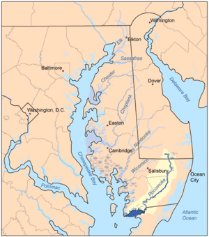
Map of the rivers of the Eastern Shore of Maryland with the Pocomoke and its watershed highlighted.
|
|
| Country | United States |
| State | Delaware, Maryland, & Virginia |
| Region | Delmarva Peninsula |
| Physical characteristics | |
| Main source | Great Cypress Swamp |
| River mouth | Pocomoke Sound 0 ft (0 m) |
| Length | 66 mi (106 km), northeast-to-southwest |
| Basin features | |
| Tributaries |
|
The Pocomoke River is about 66 miles (106 km) long. It flows from southern Delaware through southeastern Maryland in the United States. Where the river meets the Chesapeake Bay, it looks like an arm of the bay. Higher up, the river flows through hard-to-reach wetlands called the Great Cypress Swamp. This swamp is home to many Loblolly Pine, Red Maple, and Bald Cypress trees. The Pocomoke River is the easternmost river that flows into Chesapeake Bay.
The name "Pocomoke" used to be thought of as meaning "dark (or black) water." However, experts who study Algonquian languages now agree it comes from words meaning "broken (or pierced) ground."
Contents
About the Pocomoke River
The Pocomoke River starts in several places within the Great Cypress Swamp. This swamp is located in southern Sussex County, Delaware. From there, the river flows south into Maryland. It forms the border between Wicomico and Worcester counties. It also flows through the swamps named after the river.
At a place called Porter's Crossing, the river turns southwest. It becomes wider and flows slowly, winding its way along. It passes by the town of Snow Hill. Then, it goes through the Pocomoke River State Forest and past Pocomoke River State Park. After that, it flows past Pocomoke City. Finally, it enters Pocomoke Sound on the Chesapeake Bay. This is right on the border between Maryland and Virginia.
The Pocomoke River gets water from other smaller streams. Nassawango Creek joins it from the northwest, about 1 mile (1.6 km) southwest of Snow Hill. Dividing Creek joins from the north, about 1 mile northeast of Pocomoke City. The State of Maryland has named the Pocomoke River a "Scenic" river. This means it's a special place to protect for its natural beauty.
History of the River
Early Conflicts and Settlements
In 1635, the area near the mouth of the Pocomoke River saw the first recorded battle between Englishmen in North America. This fight was between the Virginia Company and Lord Baltimore. Lord Baltimore was the owner of the Maryland Colony. They were arguing over who had rights to Kent Island. Maryland colonists eventually won this dispute.
During the time when America was a colony, many "landings" grew up along the river. These were places where boats could stop. Some of these landings grew into towns, while others disappeared. This happened as people started using roads more than boats for travel.
Here are some of the important landings:
- On the right side of the river: Shelltown (also called Steamboat Landing) and Rehobeth in Somerset County. Also, Puncheon Landing, Stevens Ferry, Cottinghams Ferry, Milburn Landing (now part of Pocomoke River State Park), and Adams Wharf, all in Worcester County.
- On the left side of the river: Pitts Creek Landing in Accomack County, Virginia. Also, Cedar Hall Landing, Stevens Landing (which became Pocomoke City), Cottinghams Ferry, Mattapony Landing, and finally Snow Hill. Snow Hill was as far up the river as large boats could go. All these left-bank landings were in Worcester County.
River Management and Challenges
In 1785, Maryland and Virginia made an agreement. This happened after many years of arguments about fishing in Pocomoke Sound and the Pocomoke River. The agreement set rules for fishing and made the waterway free for everyone. It also covered how to handle legal cases involving citizens from both states. Later, in 1894, the Supreme Court of the United States decided that Pocomoke Sound was not part of this famous agreement.
In 1913, the United States Army Corps of Engineers made the mouth of the river deeper. This was done to help boats travel more easily.
In the 1990s, a tiny living thing (a microorganism) caused problems in the lower river. This microorganism, possibly Pfiesteria piscicida, led to many fish kills. It also caused health issues for people who worked on the river. These issues included skin problems, breathing difficulties, and memory problems. Because of this, the lower river and Pocomoke Sound were closed for fishing, boating, and swimming. Scientists now think this microorganism was always there. However, it became harmful because too much organic waste had built up in the river.
 | Madam C. J. Walker |
 | Janet Emerson Bashen |
 | Annie Turnbo Malone |
 | Maggie L. Walker |

