Stonefort, Illinois facts for kids
Quick facts for kids
Stonefort
|
|
|---|---|

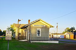
Stonefort Depot
|
|

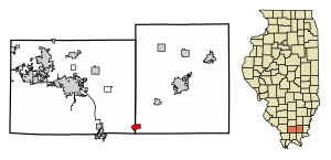
Location of Stonefort in Saline & Williamson Counties, Illinois.
|
|

Location of Illinois in the United States
|
|
| Country | United States |
| State | Illinois |
| County | Saline, Williamson |
| Area | |
| • Total | 1.46 sq mi (3.78 km2) |
| • Land | 1.45 sq mi (3.77 km2) |
| • Water | 0.01 sq mi (0.01 km2) |
| Elevation | 404 ft (123 m) |
| Population
(2020)
|
|
| • Total | 224 |
| • Density | 154.06/sq mi (59.49/km2) |
| Time zone | UTC-6 (CST) |
| • Summer (DST) | UTC-5 (CDT) |
| ZIP Code |
62987
|
| Area code(s) | 618 |
| FIPS code | 17-72884 |
| GNIS feature ID | 2399909 |
| Wikimedia Commons | Stonefort, Illinois |
Stonefort is a small village located in southern Illinois, United States. It is split between two counties: Saline County and Williamson County. In 2020, about 224 people lived there.
History of Stonefort
Stonefort gets its name from an old rock fort that was in the area. This fort was there when the first settlers arrived in the early 1800s. The village of Stonefort was first started in the late 1850s. It was originally located about a mile to the southeast, near the edge of a bluff.
Later, in the 1870s, a railroad called the Cairo and Vincennes Railroad was built through the area. Because of this new railroad, the public buildings in Stonefort were taken apart. They were then moved to where the village is today, right next to the train tracks. The old site of the village is now known as "Oldtown" on maps.
Geography of Stonefort
Stonefort is located at 37°37′0″N 88°42′26″W / 37.61667°N 88.70722°W. The village sits on top of a ridge. This ridge rises above the South Fork Saline River valley to the north. It also rises above the Little Saline River valley to the south.
U.S. Route 45 is a main road that connects Stonefort to other towns. It goes northeast to Carrier Mills and southwest to New Burnside. The Tunnel Hill State Trail also passes through Stonefort. This trail is about 45 miles (72 km) long and is a rail trail. A rail trail is a path built on old railroad lines, used for walking and biking.
According to the 2010 census, Stonefort covers a total area of about 1.46 square miles (3.78 square kilometers). Most of this area, about 1.45 square miles (3.75 square kilometers), is land. Only a very small part, about 0.006 square miles (0.016 square kilometers), is water.
Population and People
| Historical population | |||
|---|---|---|---|
| Census | Pop. | %± | |
| 1880 | 337 | — | |
| 1890 | 464 | 37.7% | |
| 1900 | 479 | 3.2% | |
| 1910 | 485 | 1.3% | |
| 1920 | 456 | −6.0% | |
| 1930 | 487 | 6.8% | |
| 1940 | 524 | 7.6% | |
| 1950 | 490 | −6.5% | |
| 1960 | 349 | −28.8% | |
| 1970 | 325 | −6.9% | |
| 1980 | 316 | −2.8% | |
| 1990 | 311 | −1.6% | |
| 2000 | 292 | −6.1% | |
| 2010 | 297 | 1.7% | |
| 2020 | 224 | −24.6% | |
| U.S. Census | |||
In 2010, there were 297 people living in Stonefort. These people lived in 131 households, and 89 of these were families. The village had 144 housing units in total.
Most of the people in the village were White, making up about 97.60% of the population. About 1.03% were African American, and 1.03% were from other races. A small number, about 1.71%, were Hispanic or Latino.
Looking at the age groups in 2010:
- About 19.2% of the people were under 18 years old.
- About 24.0% were 65 years old or older.
- The average age in the village was 47 years.
See also
 In Spanish: Stonefort (Illinois) para niños
 | Kyle Baker |
 | Joseph Yoakum |
 | Laura Wheeler Waring |
 | Henry Ossawa Tanner |


