Stonegate, Colorado facts for kids
Quick facts for kids
Stonegate, Colorado
|
|
|---|---|

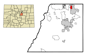
Location of the Stonegate CDP in Douglas County, Colorado.
|
|
| Country | |
| State | |
| County | Douglas County |
| Government | |
| • Type | unincorporated community |
| Area | |
| • Total | 1.844 sq mi (4.777 km2) |
| • Land | 1.832 sq mi (4.745 km2) |
| • Water | 0.012 sq mi (0.032 km2) |
| Elevation | 5,896 ft (1,797 m) |
| Population
(2020)
|
|
| • Total | 9,072 |
| • Density | 4,918.6/sq mi (1,899.10/km2) |
| Time zone | UTC-7 (MST) |
| • Summer (DST) | UTC-6 (MDT) |
| ZIP Code |
80134
|
| Area codes | 303 & 720 |
| GNIS feature | Stonegate CDP |
Stonegate is a community in Douglas County, Colorado, United States. It's not an official town, but it's recognized as a census-designated place (CDP). This means the government tracks its population and other facts. Stonegate is part of the larger Denver–Aurora–Lakewood, CO Metropolitan Statistical Area. In 2020, about 9,072 people lived there. The community gets its services from the Stonegate Village Metropolitan District. It uses the ZIP Code 80134.
Where is Stonegate?
Stonegate is located in the northeastern part of Douglas County. To its east, you'll find the town of Parker. To the west, there's another community called Grand View Estates.
The E-470 toll road, which goes around the east side of the Denver-Aurora area, forms the northern border of Stonegate. You can get to Stonegate from Exits 3 and 4 on this road. Downtown Denver is about 21 miles (34 km) to the northwest.
The Stonegate CDP covers an area of about 1.84 square miles (4.777 square kilometers). A small part of this area, about 0.012 square miles (0.032 square kilometers), is water.
How Many People Live Here?
The United States Census Bureau first officially counted Stonegate's population for the United States Census 2000. A census is like a big count of everyone living in a country. It helps the government understand how communities are growing and what they need.
| Stonegate CDP, Colorado | ||
|---|---|---|
| Year | Pop. | ±% |
| 2000 | 6,284 | — |
| 2010 | 8,962 | +42.6% |
| 2020 | 9,072 | +1.2% |
| Source: United States Census Bureau | ||
Schools in Stonegate
Students living in Stonegate attend schools that are part of the Douglas County School District.
See also
 In Spanish: Stonegate para niños
 | Delilah Pierce |
 | Gordon Parks |
 | Augusta Savage |
 | Charles Ethan Porter |


