Stoutsville, Missouri facts for kids
Quick facts for kids
Stoutsville, Missouri
|
|
|---|---|
|
Village
|
|

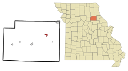
Location in Monroe County and the state of Missouri
|
|
| Country | United States |
| State | Missouri |
| County | Monroe |
| Area | |
| • Total | 0.83 sq mi (2.16 km2) |
| • Land | 0.82 sq mi (2.13 km2) |
| • Water | 0.01 sq mi (0.02 km2) |
| Elevation | 610 ft (190 m) |
| Population
(2020)
|
|
| • Total | 37 |
| • Density | 44.96/sq mi (17.35/km2) |
| Time zone | UTC-6 (Central (CST)) |
| • Summer (DST) | UTC-5 (CDT) |
| ZIP code |
65283
|
| Area code(s) | 573 |
| FIPS code | 29-71026 |
| GNIS feature ID | 2399912 |
Stoutsville is a small village in Monroe County, Missouri, in the United States. In 2020, the population of the village was 37 people.
Contents
History of Stoutsville
Stoutsville was officially planned and marked out in 1871. It was named after the family of Robert P. Stout. The Stout family originally owned the land where the village was built. A post office opened in Stoutsville in 1872 and has been operating ever since.
Geography of Stoutsville
Stoutsville is located in the northeast part of Monroe County. It is very close to where Buck Creek flows into Mark Twain Lake. The village is also just south of U.S. Route 24, a main road.
Paris, which is the main town of Monroe County, is about 10 miles (16 km) southwest of Stoutsville. Monroe City is about 11 miles (18 km) northeast, also along US 24.
The village covers a total area of about 0.83 square miles (2.16 square kilometers). Most of this area, about 0.82 square miles (2.13 square kilometers), is land. A small part, about 0.01 square miles (0.02 square kilometers), is water. The village is in the area where water flows into the Salt River. The Salt River then flows east into the Mississippi River.
Population Changes in Stoutsville
| Historical population | |||
|---|---|---|---|
| Census | Pop. | %± | |
| 1880 | 118 | — | |
| 1890 | 253 | 114.4% | |
| 1900 | 196 | −22.5% | |
| 1910 | 315 | 60.7% | |
| 1920 | 247 | −21.6% | |
| 1930 | 153 | −38.1% | |
| 1940 | 179 | 17.0% | |
| 1950 | 146 | −18.4% | |
| 1960 | 109 | −25.3% | |
| 1970 | 61 | −44.0% | |
| 1980 | 34 | −44.3% | |
| 1990 | 26 | −23.5% | |
| 2000 | 44 | 69.2% | |
| 2010 | 36 | −18.2% | |
| 2020 | 37 | 2.8% | |
| U.S. Decennial Census | |||
The population of Stoutsville has changed a lot over the years. In 1880, there were 118 people. The population grew to 315 in 1910, which was its highest point. Since then, the number of people living in Stoutsville has generally decreased.
Stoutsville in 2010
According to the census from 2010, 36 people lived in Stoutsville. There were 16 households, which are groups of people living together. Most of these households, 14 of them, were families.
The average age of people in the village was about 48.5 years old. About half of the residents were male and half were female.
See also
- In Spanish: Stoutsville (Misuri) para niños
 | John T. Biggers |
 | Thomas Blackshear |
 | Mark Bradford |
 | Beverly Buchanan |

