
Stowe's Hill facts for kids
Quick facts for kids Stowe's Hill |
|
|---|---|

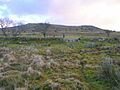
Stowe's Hill from the west.
|
|
| Highest point | |
| Elevation | 381 m (1,250 ft) |
| Prominence | 78 m (256 ft) |
| Listing | TuMP |
| Geography | |
| Location | Bodmin Moor, England |
| OS grid | SX257724 |
| Topo map | OS Landranger 201, Explorer 109 |
| Geology | |
| Mountain type | granite tor |
Stowe's Hill is a tall hill found on the eastern edge of Bodmin Moor in Cornwall, England. It stands about 381 metres (1,250 ft) high. This hill is famous for its interesting rock formations and ancient sites.
It's a great place to explore history and nature. You can find unique granite rocks and learn about people who lived there long ago.
Contents
Exploring Stowe's Hill
Stowe's Hill is a noticeable granite ridge. It is located about 1.5 kilometers north of Minions. Minions is the highest village in Cornwall. The hill is known for its special features.
Stowe's Pound: An Ancient Enclosure
One of the most important parts of Stowe's Hill is Stowe's Pound. This is a huge tor enclosure. It is made up of two very large stone walls. These walls were built a long time ago.
The smaller wall surrounds the rock formations, called tors, at the southern end of the hill. The larger wall goes around the rest of the ridge. This area was likely used by ancient people.
What's Inside Stowe's Pound?
Inside Stowe's Pound, you can find many signs of ancient life. There are two Bronze Age cairns. Cairns are piles of stones, often used as burial mounds.
You can also see the remains of a stone round house. Plus, there are over 100 platforms where houses once stood. Experts believe this site was used during the Neolithic or Bronze Age. It was likely connected to other settlements and special places nearby.
The Cheesewring: A Natural Wonder
Stowe's Hill is also famous for a unique rock formation called the Cheesewring. This amazing granite structure looks like a stack of giant cheese wheels. It gave its name to a large, old quarry nearby.
The Cheesewring was formed naturally over thousands of years. Wind and rain slowly shaped the granite rocks into this unusual stack. It's a popular spot for visitors to see.
The Quarry Near the Cheesewring
At the southern end of Stowe's Hill, there is a large, disused quarry. This quarry was once used to dig out granite. The granite from here was used for building. The Cheesewring itself was almost destroyed by quarrying in the 19th century. Luckily, it was saved.
Images for kids
-
Stowe's Hill from the west.
