
Stuart Lake facts for kids
Quick facts for kids Stuart Lake |
|
|---|---|
 |
|

Stuart Lake
Location in British Columbia
|
|
| Location | British Columbia |
| Group | Nechako Lakes |
| Coordinates | 54°33′N 124°35′W / 54.550°N 124.583°W |
| Catchment area | 14,600 km2 (5,600 sq mi) |
| Basin countries | Canada |
| Max. length | 90 km (56 mi) |
| Max. width | 13 km (8.1 mi) |
| Surface area | 358 km2 (138 sq mi) |
| Average depth | 26 m (85 ft) |
| Max. depth | 95 m (312 ft) |
| Water volume | 9.3 km3 (7,500,000 acre⋅ft) |
| Shore length1 | 170 km (110 mi) |
| Surface elevation | 680 m (2,230 ft) |
| Settlements | Fort St. James |
| 1 Shore length is not a well-defined measure. | |

Stuart Lake is a large and beautiful lake in the northern part of British Columbia, Canada. Its original name, in the Dakelh language, is Nak'albun, which means "Mount Pope Lake." This name comes from Mount Pope, a mountain that stands tall over the lake.
The town of Fort St. James is located right by the lake. This town is close to where the Stuart River flows out of the lake. The Stuart River is also known as Nak'alkoh, or "Mount Pope River." Stuart Lake is quite big, stretching about 66 kilometers (41 miles) long and 10 kilometers (6 miles) wide. It's also fairly shallow, with an average depth of 26 meters (85 feet).
Contents
Fun Things to Do at Stuart Lake
Stuart Lake is a great place for many outdoor activities, especially during the warmer months.
- You can go boating and water skiing on its wide-open waters.
- The lake has sandy beaches perfect for swimming and sunbathing.
- If you like fishing, you'll find many types of fish here.
- You can also explore and see ancient aboriginal pictographs, which are old rock paintings.
- For those who love nature, there are places for camping too.
During winter, when the lake freezes over, it becomes a playground for different activities:
- Snowmobiling
- Ice fishing
- Ice sailing
- Dog sledding
There are two provincial parks on the southern shore of the lake, Paarens Beach and Sowchea Bay. These parks offer great spots for camping. You can also find motels, lodges, and private campgrounds nearby. If you have a boat, there are several marinas where you can dock it.
Fish and Wildlife in Stuart Lake
Stuart Lake is home to many different kinds of fish. Anglers (people who fish) can often catch:
- Rainbow trout
- Lake trout (also known as char)
- Whitefish
- Kokanee (a type of salmon)
- Dolly Varden (a type of trout)
- Burbot (a freshwater cod)
The lake is usually covered in ice from mid-December until early May, making it a popular spot for ice fishing during those months.
History of Stuart Lake
Stuart Lake has a very important place in the history of British Columbia. It is the location of one of the oldest non-native settlements in the province, Fort St. James.
Ancient Trails and Trade
Long ago, villages on Stuart Lake (Nak'albun) were connected to other Dakelh villages on Fraser Lake by an old land route. This trail was called Nyan Wheti, which means "The Way Across" in the Carrier language. It was part of a larger network of trails known as the Grease Trails. These trails were very important for the Dakelh people. They used them for:
- Trading goods
- Traveling between communities
- Communicating with each other
Another trail, the Cheslatta Trail, continued south from this area to Cheslatta Lake.
First European Visitors
The first non-native person to visit Stuart Lake was James McDougall in 1806. He was helping a famous explorer named Simon Fraser. Soon after, Fraser and his team set up a trading post for the North West Company right on the lake. They left a group of people there for the winter, led by a clerk named John Stuart. The lake was later named "Stuart Lake" in his honor.
The Original Name
The original name of the lake in the Dakelh language is Nak'albun. This name means "Mount Pope Lake," named after the mountain, Nak'al, which overlooks it. The change from Nak'albun to Stuart Lake shows how names of places often changed during the time when Canada was being settled by Europeans.
Protecting the Lake
In 2012, the local government of Fort St. James voted against a big pipeline project called the Enbridge Northern Gateway Project. They were worried about how the pipeline might affect the land and especially the fresh water sources around the lake. They were very concerned about the pipeline crossing the Stuart River, which is a vital pathway for one of the world's largest runs of sockeye salmon. They also worried about Pitka Creek, which flows into Stuart Lake. Their decision showed how important it is to protect the natural environment and its resources.
Images for kids
-
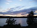
A view of Stuart Lake.
See also
 In Spanish: Lago Stuart para niños
