
Sudbury River facts for kids
Quick facts for kids Sudbury River |
|
|---|---|

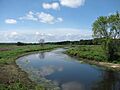
Section of the river in Wayland, Massachusetts
|
|
| Country | United States |
| State | Massachusetts |
| Type: | Scenic, Recreational |
| Designated: | April 9, 1999 |
The Sudbury River is a river in Massachusetts, USA. It flows for about 32.7 miles (52.6 kilometers). This river is a branch of the Concord River. It is located in Middlesex County, Massachusetts.
The Sudbury River starts in a swampy area called Cedar Swamp. This swamp is in Westborough, Massachusetts, near Hopkinton. The river then winds its way northeast. It passes through Fairhaven Bay. Finally, it meets the Assabet River at a spot called Egg Rock in Concord, Massachusetts. When these two rivers meet, they form the Concord River. The area of land that drains water into the Sudbury River is about 162 square miles.
In 1999, a large part of the Sudbury River was given a special honor. Nearly 17 miles (27 kilometers) of the river became part of the National Wild and Scenic Rivers System. This means the river is recognized for its amazing nature, history, beautiful views, and fun activities. It also has a special place in American literature.
A 14.9-mile (24-kilometer) part of the river is called a "Scenic River." This section starts at the Danforth Street Bridge in Framingham. It goes downstream to the Route 2 bridge in Concord. Another 1.7-mile (2.7-kilometer) part is called a "Recreational River." This section goes from the Route 2 bridge to where it joins the Assabet River at Egg Rock. Parts of the Assabet and Concord rivers also have this special status.
In the 1970s, scientists found mercury pollution in the river. This pollution came from a factory in Ashland. The Environmental Protection Agency (EPA) worked to clean up the area. Even though there has been a cleanup, it is still advised not to eat fish caught from the lower parts of the river.
Contents
River's Name History
The Sudbury River has had different names over time. In 1834, a book about Concord's history said that the river upstream of the Assabet River was often seen as part of the Concord River. Sometimes, people called it the "south branch" of the Concord River.
In old town records for Sudbury, the river was first called the "Great River." Later, it became known as the Sudbury River. West of Framingham, people used to call it the "Hopkinton River." This was because it flows near Hopkinton. It wasn't until maps from 1856 that the entire river, from Westborough to Concord, was consistently called the Sudbury River.
River's Journey and Features
The Sudbury River begins at Cedar Swamp Pond. This is a swampy area in Westborough. It starts at an elevation of about 327 feet (100 meters). From there, it flows northeast for 32.7 miles (52.6 kilometers).
As it flows, the river passes through several towns. These include Westborough, Hopkinton, Southborough, Ashland, Framingham, Wayland, Sudbury, and Lincoln. Finally, it reaches Concord. In Concord, it meets the Assabet River at Egg Rock. This meeting point is about 100 feet (30 meters) above sea level. Here, the two rivers combine to form the Concord River.
As of 2017, there are five old dams on the Sudbury River. Two of these are the Framingham Reservoir dams. The Fenwick Street Dam and Saxonville Dam are in Framingham. The Myrtle Street Dam is in Ashland. Many bridges cross the river too. There are 34 road bridges, five railroad bridges, and two footbridges. The total area that drains water into the river is 162 square miles.
River Flow and Flooding
Since 1979, the U.S. Geological Survey (USGS) has measured the river's depth and flow. They have a special gauge downstream of the Danforth Street Bridge in Framingham. The area of land that drains into the river above this gauge is 106 square miles. This is about 65% of the river's total drainage area.
The average flow rate of the river is 201 cubic feet per second (cfs). This is based on data from 1981 to 2016. The flow rate changes with the seasons. In summer, the average flow is about 80 cfs. In spring, it averages around 375 cfs. The highest flow ever recorded was 2,570 cfs on March 31, 2010. On that day, the water depth at the gauge was 13.95 feet. If the water depth goes over 13.0 feet, it means the river is in a major flood. Before 2010, the last major flood was on April 8, 1987, when the depth was 13.47 feet.
Invasive Water Plants
An invasive plant called water caltrop, or water chestnut, is a problem in the Sudbury River. Its scientific name is Trapas natans. This plant originally came from western Asia. It was first brought to the U.S. in the 1870s in Cambridge, Massachusetts. People then purposely put it into ponds near the Concord and Sudbury Rivers.
Now, water chestnut is an invasive plant that harms the environment. It spreads across many eastern states. On the Sudbury River, a group called OARS (Organization for the Assabet, Sudbury and Concord Rivers) helps fight this plant. They organize yearly events where volunteers go out in canoes. They hand-pull the floating leaves and nuts of the plant. They do this before the nuts mature and fall to the river bottom. The water chestnut is a big problem between the Fenwick Street and Saxonville dams. In this area, more than 80% of the water surface can be covered by the plant.
Boating Fun on the River
If you like boating, the Sudbury River is a great place to explore! OARS, the Organization for the Assabet, Sudbury and Concord Rivers, has helpful maps online. These maps show six different sections of the Sudbury River. They also tell you where you can put your canoe or kayak into the water.
If you don't have your own boat, you can rent one. The South Bridge Boat House in Concord offers canoes and kayaks for rent. From there, you can explore many miles of calm waterways on the Assabet, Sudbury, and Concord Rivers. It's a fun way to see the river and its surroundings.
Images for kids
-
Sudbury River in Wayland
-
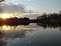
Sherman's Bridge Landing, Wayland
-
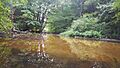
Downstream from the little falls, Simpson Park, Framingham


