
Assabet River facts for kids
Quick facts for kids Assabet River |
|
|---|---|

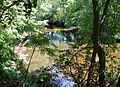
Assabet River channel in Stow, Massachusetts
|
|
| Country | United States |
| State | Massachusetts |
| Physical characteristics | |
| Length | 34.4 miles (55.4 km) |
| Type: | Recreational |
| Designated: | April 9, 1999 |
The Assabet River is a small river in Massachusetts, United States. It is about 34.4-mile (55.4 km) long. The river starts in a wet area called the Assabet Reservoir in Westborough, Massachusetts. It then flows northeast.
The Assabet River joins the Sudbury River at a place called Egg Rock in Concord, Massachusetts. Together, they form the Concord River. The Concord River then flows into the Merrimack River. This means the Assabet, Sudbury, and Concord rivers are all part of the larger Merrimack River system.
An organization called OARS (Organization for the Assabet, Sudbury and Concord Rivers) works to protect these three rivers. They are based in West Concord, Massachusetts. Their goal is to keep the rivers and their surrounding areas healthy and fun for everyone.
Contents
What's in a Name? The Assabet River's Story
The name "Assabet" has changed many times over the years. Its exact meaning is not fully known. Native American groups who lived here had different ideas about the name.
Some say Assabet comes from an Algonquian word. This word meant "the place where materials for making fish nets come from." Other meanings include "at the muddy place" or "it is muddy."
The Nipmuc people lived and fished along the river long ago. They spoke a language called Loup language. In their language, assa-pe-t might mean "at the place where the river turns back." This makes sense because during floods, the Assabet River can rise faster than the Sudbury River. This can make the Sudbury River's flow temporarily reverse direction where the two rivers meet.
Some people thought the name "Assabet" was a changed spelling of "Elizabeth." Old maps and papers show many different spellings. These include Asibath, Assabeth, Elizbeth, and Elizabeth. The spelling "Assabet" became common around 1850. Before that, many maps called it the Elizabeth River.
A Look Back: The Assabet River's History
Long before European settlers arrived, Indigenous people lived in central Massachusetts for thousands of years. The Nipmuc people had settlements near and along the Assabet River. Their stories, old artifacts, and early European writings all show this.
The Nipmuc settlements along the Assabet were close to the lands of other Algonquian-speaking groups. These included the Massachusett, Pennacook, and Wampanoag peoples.
Where is the Assabet River?

The Assabet River begins in a 310-acre (130 ha) swampy area. This area is in Westborough and is called the Assabet Reservoir. Small streams from Shrewsbury and Grafton flow into this reservoir.
From Westborough, the river flows northeast for 34.4 miles (55.4 km). It starts at a height of 320 feet (98 m). It then flows through towns like Northborough, Marlborough, Hudson, and Stow. Finally, it reaches Concord. Here, it meets the Sudbury River at Egg Rock. This meeting point is at a height of 100 feet (30 m). Together, they form the Concord River.
The area that drains into the Assabet River is about 177 square miles (460 km2). The Assabet marshes in Stow are about 900 acres (360 ha). The Assabet River National Wildlife Refuge is a large protected area. It covers 2,600 acres (1,100 ha) in Stow, Maynard, Sudbury, and Marlborough.
How Much Water Flows in the River?
The U.S. Geological Survey keeps track of the river's flow. At a measuring spot in Maynard, the river's average flow is 200 cubic feet (5.7 m3) per second. In February, March, and April, the flow is usually higher, over 300 cubic feet (8.5 m3) per second. In summer months like July, August, and September, the flow is lower, less than 100 cubic feet (2.8 m3) per second. Sometimes, it can be as low as 40 cubic feet (1.1 m3) per second.
Five water treatment plants release cleaned water into the Assabet River. In summer, this cleaned water can make up more than half of the river's total volume. This is about 10,000,000 US gallons (38,000,000 L) each day.
Bridges and Dams Along the River
As of 2020, there are nine dams on the Assabet River. Seven of these dams used to power mills. These include the Aluminum City, Hudson, and Powdermill dams. The Nichols and Tyler dams were built more recently to help control floods. The Damonmill Dam is partly broken, so it doesn't hold back water, but it can slow the flow during floods.
Many bridges cross the river. There are 39 road bridges. The Assabet River Rail Trail has two bridges for walkers and bikers. There is also one old railroad bridge and one active railroad bridge.
The Powdermill Dam was built for the American Powder Mills. This was a large factory that made gunpowder from 1835 to 1940. It had 40 buildings spread over 400 acres (160 ha) along the river. There were 23 recorded explosions at the mills over the years. Today, a company plans to use the Powdermill Dam to make electricity again.
Who Lives in and Around the Assabet River?

Even though the Assabet River is small and surrounded by towns, it is home to many plants and animals. These include trees, wildflowers, water plants, birds, fish, mammals, reptiles, amphibians, and insects. However, some plants that are not native to the area are causing problems for the local plants.
Native Plants and Animals
Many types of trees grow near the Assabet River. These include red maple, silver maple, black willow, and hemlock. There are also shrubs like buttonbrush and common elderberry.
The riverbanks are full of beautiful Wildflowers. You can see blue flag and yellow flag flowers. Other wildflowers include cardinal flower, jewelweed, and pickerelweed. Marsh plants like common cattail and royal fern also grow here. In the water, you might find duckweed, white water lily, and yellow pond lily.
Many different birds live near the Assabet River. Some, like the belted kingfisher, are here in summer. Others, like the American yellow warbler and Baltimore oriole, migrate here in spring. Birds like the black-capped chickadee and downy woodpecker stay all year. You might also see birds that prefer open fields, like the barn swallow and bobolink. Marsh birds like the great blue heron and red-winged blackbird are also common.
Many types of ducks visit the Assabet River. These include the American black duck and mallard. You might also spot birds of prey like the osprey or red-tailed hawk.
The river is home to many fish. Brook trout, chain pickerel, and largemouth bass are common. The Massachusetts Division of Fisheries and Wildlife adds brook trout to the river's smaller streams. Other native fish include American eel, black crappie, and yellow perch.
Common mammals living near the river are minks, muskrats, raccoons, and white-tailed deer. North American river otters are less common but can be seen.
Several reptiles live in the Assabet's waters. These include the common snapping turtle, common watersnake, and painted turtle. Some rare turtles, like the Blanding's turtle, are also found here but are hard to spot. Many amphibians live in the watershed. Common ones are the American bullfrog, green frog, and spring peeper. Freshwater crayfish also live in the river.
The shaded banks of the Assabet are perfect for damselfly and dragonfly species. They lay their eggs underwater. Common types include the black-winged damselfly and common whitetail dragonfly. Other water insects like common water strider and whirligig beetles can be seen on the water's surface.
Plants and Animals That Don't Belong Here
Water caltrop, also known as water chestnut, is a plant that is not native to the United States. It was brought here in the 1870s. Now, it grows too much and harms the native plants in many eastern states, including along the Assabet River. OARS organizes an event every July where volunteers use canoes to pull out these plants by hand. This helps stop them from spreading.
Other non-native species in the Assabet area include the European water clover plant and the carp fish.
Animals That Used to Live Here
Alewife are a type of fish that are born in freshwater but live most of their lives in the ocean. Long ago, they would swim from the Atlantic Ocean up the Merrimack, Concord, Assabet, and Sudbury rivers to lay their eggs. But when factories built dams on these rivers, the alewife could no longer swim upstream. This caused them to disappear from these rivers.
Beavers were also very common in the Assabet area before European settlers arrived. People hunted them for their fur. By 1750, beavers were gone from Massachusetts. However, beavers were brought back to the state starting around 1930. Now, they are back in the Assabet River area. They build dams that create wetlands. These wetlands help many other animals and plants, and they also store water. Sometimes, beavers build dams in places that cause problems for people, so they need to be moved.
Floods and How We Control Them
Major flooding on the Assabet River happens when the water is more than 7 feet (2.1 m) deep. It also means the water is flowing at 2,300 cubic feet (65 m3) per second. This is measured at a special gauge in Maynard.
Past Floods
- 1927: A tropical storm brought heavy rains in November 1927. This caused bad flooding across New England. Locally, bridges were damaged, and buildings near the river flooded. The Waltham Street Bridge in Maynard was destroyed and had to be rebuilt.
- 1936: This was called the "Great Flood of 1936" and was one of the worst in New England. A very cold winter with lots of snow was followed by early spring warmth and heavy rain. This caused rivers to overflow.
- 1955: The remains of Hurricane Diane caused floods in 1955. The Assabet River reached its highest water level ever recorded at 8.94 feet (2.72 m).
- 1968 and 1979: These floods happened after new flood control dams were built. Both floods peaked at 8.1 feet (2.5 m). In 1968, water went over a wall near factory buildings, and workers had to use sandbags and pumps. By 1979, the wall was made higher, so the water did not reach the buildings.
How We Control Floods Today
There are three main dams and eight smaller sites that help control floods. The George H. Nichols Dam was built in Westborough around 1968. The Tyler Dam in Marlborough was built in 1965. The Delaney Complex, on a smaller stream, was built in Stow in 1971. These sites can hold back a huge amount of water, over 3.5 trillion US gallons (1.3×10¹³ L). The Nichols Dam also helps keep water flowing in the river when levels are low. The most recent major floods were in 1987 and 2010.
The Assabet River in Books
The Assabet River has been written about by famous authors.
Nathaniel Hawthorne wrote about the river in his book Mosses from an Old Manse. He said it was a "lovely stream" and that it was very calm and peaceful, even when there was a storm elsewhere. He felt it was like a place from a poet's imagination.
Henry David Thoreau often visited the Assabet River. He even took his students, including Louisa May Alcott, on boat trips there to learn. Thoreau wrote a poem called "The Assabet." The first part of the poem talks about rowing on the river on a summer day.
In his journal, Thoreau wrote about how wonderful it felt to walk in the river on a hot day. He compared it to the fancy baths of ancient Roman emperors and thought his experience was much better. He described walking through shallow water, then deeper parts, and seeing plants like water lilies.
Images for kids
-
The Assabet River near Route 2, Concord, Massachusetts
