West Concord, Massachusetts facts for kids
Quick facts for kids
West Concord, Massachusetts
|
|
|---|---|

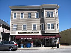
West Concord 5&10
|
|

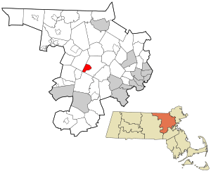
Location in Middlesex County, Massachusetts
|
|
| Country | United States |
| State | Massachusetts |
| County | Middlesex |
| Town | Concord |
| Area | |
| • Total | 3.58 sq mi (9.27 km2) |
| • Land | 3.38 sq mi (8.75 km2) |
| • Water | 0.20 sq mi (0.53 km2) |
| Elevation | 118 ft (36 m) |
| Population
(2020)
|
|
| • Total | 6,320 |
| • Density | 1,872.04/sq mi (722.70/km2) |
| Time zone | UTC-5 (Eastern (EST)) |
| • Summer (DST) | UTC-4 (EDT) |
| ZIP code |
01742 (Concord)
|
| Area code(s) | 978 |
| FIPS code | 25-75680 |
| GNIS feature ID | 0611517 |
West Concord is a small community in the town of Concord, Massachusetts. It is located in Middlesex County, in the United States. It is called an "unincorporated village" and a "census-designated place" (CDP). This means it's a recognized community without its own separate local government. In 2020, about 6,320 people lived there.
Contents
Exploring West Concord's Location
West Concord is found in the middle of Middlesex County. It's in the southwestern part of the larger town of Concord. The community is bordered by different natural and man-made features. To the north, you'll find Massachusetts Route 2. To the southeast, there are brooks like Dugan Brook. The towns of Sudbury and Acton are to its southwest and west.
Roads and Rivers in West Concord
Massachusetts Route 62 is a main road that goes through West Concord. It's known as Main Street. This road leads east about 2 miles (3.2 km) to the center of Concord. It also goes southwest about 3.5 miles (5.6 km) to Maynard. A bigger highway, Route 2, is also nearby. It leads southeast about 17 miles (27 km) to Cambridge. It also goes northwest about 21 miles (34 km) to Leominster.
West Concord covers an area of about 3.58 square miles (9.27 km2). Most of this area is land, about 3.38 square miles (8.75 km2). The rest, about 0.20 square miles (0.53 km2), is water. The Assabet River flows through the village. It runs northeast and joins the Concord River. This happens on the north side of Concord village. West Concord also has two ponds: Warners Pond in the north and Kennedys Pond in the southwest. All these waterways are part of the larger Merrimack River system.
People Living in West Concord
West Concord has seen its population grow over the years. Here's a look at how many people have lived there:
| Historical population | |||
|---|---|---|---|
| Census | Pop. | %± | |
| 1950 | 1,285 | — | |
| 1960 | 1,556 | 21.1% | |
| 1980 | 5,331 | — | |
| 1990 | 5,761 | 8.1% | |
| 2000 | 5,632 | −2.2% | |
| 2010 | 6,028 | 7.0% | |
| 2020 | 6,320 | 4.8% | |
| U.S. Decennial Census | |||
In 2000, there were 5,632 people living in West Concord. They lived in 1,844 households. Many of these households (about 59.7%) were married couples. About 34.2% of households had children under 18 living with them. The average household had about 2.48 people. The average family had about 3.00 people.
The community is made up of people of different ages. About 20.3% of the population was under 18. About 12.8% was 65 or older. The average age in West Concord was 39 years old.
More Information

- In Spanish: West Concord (Massachusetts) para niños

