
Assabet River National Wildlife Refuge facts for kids
Quick facts for kids Assabet River National Wildlife Refuge |
|
|---|---|
|
IUCN Category IV (Habitat/Species Management Area)
|
|

Puffer Pond
|
|

Assabet River National Wildlife Refuge
Location in the United States
|
|
| Location | Hudson, Maynard, Stow, Sudbury, Massachusetts, United States |
| Nearest city | Maynard, Massachusetts |
| Area | 2,230 acres (9.0 km2) |
| Established | 2005 |
| Governing body | U.S. Fish and Wildlife Service |
The Assabet River National Wildlife Refuge (often called ARNWR) is a special protected area. It covers about 2,230-acre (9.0 km2) of land. This refuge is located in Massachusetts, near the towns of Hudson, Maynard, Stow, and Sudbury. It's about 25 miles (40 km) west of Boston.
The refuge follows the Assabet River. It's made up of two main parts. There's a northern section and a southern section. You can find a visitor center in the northern part of the refuge.
Contents
What Animals Live Here?

The refuge is home to many different animals. It has forests with pine and hardwood trees. There are also old fields and wetlands. Some wetlands are called vernal pools. These are temporary ponds that fill with water in spring.
This area is very important for migratory birds. These birds fly long distances to find food and raise their young here. You might also see otters, minks, and turkeys. Other animals include coyotes, beavers, foxes, and deer.
A special animal found here is the rare Blanding's turtle. Scientists are working hard to help more of these turtles survive. About 70% of the refuge is forest. There are also 476 acres of wetlands. This makes it a perfect home for many kinds of birds and other wildlife.
Visiting the Refuge

The Assabet River National Wildlife Refuge opened to visitors in 2005. It's a great place to enjoy nature. You can observe wildlife and explore the outdoors.
There are about 15 miles (24 km) of trails for you to use. You can walk or hike on all of them. About half of these trails are also open for biking. You can get a map of the trails at the visitor center. You can also find maps on the refuge's website.
The Assabet River Rail Trail connects to the refuge. This trail is a fun way to get around. It's a great path for walking or biking.
You can also go hunting and fishing in certain areas. There are specific seasons for hunting deer, turkeys, and other small game.
To protect the wildlife, some things are not allowed. Please do not bring dogs or other pets. Horses, fires, and overnight camping are also not permitted. You cannot use ATVs or snowmobiles here either.
Friends of the Refuge
The Friends of the Assabet River National Wildlife Refuge (FARNWR) is a special group. It's a non-profit group that helps the refuge. They formed in 2000, even before the land became a wildlife refuge.
This group helps in many ways. They make sure the refuge is safe for visitors. They also study the animals and plants. For example, they look at vernal pools and birds of prey. They also work to remove invasive plants. These are plants that can harm the local environment. The Friends group also teaches people about the refuge. They help everyone learn about its importance.
History of the Land

Long ago, Native Americans lived on this land. Later, in the 1700s, it became farmland for early colonists. During the American Revolutionary War, important supplies traveled through here. Ammunition wagons used Old Marlborough Road. This road is now a path in the refuge.
In 1851, a famous writer named Henry David Thoreau walked here. He wrote about the Assabet River in his journal. He even wrote a poem about "Old Marlborough Road." Parts of this old road are now called Winterberry Way and Powerline Trail.
The land became a military site in 1942. This was during World War II. The government took the land to build the Fort Devens-Sudbury Training Annex. People living there had to leave quickly.
One interesting part of the refuge's history is the old ammunition bunkers. These were built during World War II. The site was chosen because it was easy to ship things by train. It was also far enough inland to be safe from enemy ships. There are 50 of these bunkers, called "igloos." They were built to store ammunition safely. Each bunker was covered with dirt. This helped protect them and hide them from planes. Sometimes, Bunker #303 is open for tours.
After World War II, the site was used for training soldiers. It was also used for testing military equipment. In the 1980s, it was found that the land had some chemicals. These included arsenic and pesticides. The EPA helped clean up the site. The Army worked for years to make the land safe again. In 2000, the land was given to the U.S. Fish & Wildlife Service. That's when it became the wildlife refuge we know today.
Images for kids
-
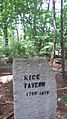
Site of Rice Tavern, a former colonial tavern. You can see its old foundation.
-
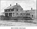
Rice Tavern before it was taken down in 1942.
-
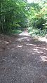
A path near the Old Marlboro Road entrance in Maynard.


