
Ashland, Massachusetts facts for kids
Quick facts for kids
Ashland, Massachusetts
|
|||
|---|---|---|---|

Ashland Public Library (2010)
|
|||
|
|||
| Nicknames:
The Clock Town
The Home of the Electric Clock |
|||

Location in Middlesex County in Massachusetts
|
|||

Ashland, Massachusetts
Location in Massachusetts

Ashland, Massachusetts
Location in the United States

Ashland, Massachusetts
Location in North America
|
|||
| Country | United States | ||
| State | Massachusetts | ||
| County | Middlesex | ||
| Settled | 1750 | ||
| Incorporated | 1846 | ||
| Government | |||
| • Type | Open town meeting | ||
| Area | |||
| • Total | 12.9 sq mi (33.5 km2) | ||
| • Land | 12.4 sq mi (32.2 km2) | ||
| • Water | 0.5 sq mi (1.2 km2) | ||
| Elevation | 188 ft (57 m) | ||
| Population
(2020)
|
|||
| • Total | 18,832 | ||
| • Density | 1,518.7/sq mi (584.8/km2) | ||
| Time zone | UTC-5 (Eastern) | ||
| • Summer (DST) | UTC-4 (Eastern) | ||
| ZIP code |
01721
|
||
| Area code(s) | 508 / 774 | ||
| FIPS code | 25-02130 | ||
| GNIS feature ID | 0619394 | ||
| Website | www.ashlandmass.com | ||


Ashland is a town in Middlesex County, Massachusetts, United States. It is part of the MetroWest area. In 2020, about 18,832 people lived there.
Contents
History of Ashland
The area where Ashland is today was first settled in the early 1700s. Before that, the Megunko Native Americans lived there. A hill in town, Megunko Hill, is named after them.
Ashland was once called "Unionville." It became an official town in 1846. Its name comes from the Kentucky home of a famous statesman, Henry Clay. Ashland is newer than many towns around it. Its land was taken from parts of Hopkinton, Holliston, and Framingham.
Railroads and Industry
The building of the Boston & Worcester Railroad in the 1830s was very important for Ashland's early growth. Later, two more train lines opened stations in town. These railroads, along with the Sudbury River, helped many factories start up. Ashland became known for making boots and shoes.
However, in 1878, the Boston Water Board built three reservoirs along the river. This stopped new factories from being built. Even though the shoe factories closed, new train lines offered service in Ashland starting in the 1890s. These lines were gone by the 1920s because cars became more popular.
The Electric Clock Town
Around the same time, an inventor named Henry E. Warren created something amazing in 1916. He invented the Warren Synchronizing Timer. This invention made electric clocks possible by keeping electricity flowing steadily.
Warren started a company called Telechron. Working with General Electric, Telechron made electric clocks in Ashland until 1979. A Warren Synchronizing Timer is now on display at the Smithsonian's Museum of American History in Washington D.C. Because of this history, Ashland's high school sports teams are called "The Clockers."
Growth and Modern Ashland
For most of the 1900s, Ashland's population grew slowly. But after the 1950s, it grew much faster. Ashland changed from a quiet country town to a busy residential suburb by the 1980s. Many farms and open spaces became housing areas. However, some natural land still remains. This includes the Ashland Town Forest, Ashland State Park, and Warren Woods.
Two main roads, Route 135 and Route 126, go through Ashland. Route 135 has older homes and is part of the Boston Marathon route. The marathon used to start in Ashland until 1924. Route 126 has grown quickly since the 1980s, with new shopping centers and homes.
Ashland is in a great spot, about halfway between Boston and Worcester. It's easy to travel from Ashland. The town has its own stop on the Framingham/Worcester Commuter Rail Line. Major highways like I-90 and I-495 are also nearby.
Even though Ashland has grown, it still feels like a friendly New England town. Traditions like Ashland Day and local favorites like Murphy's ice cream shop keep the community close. Ashland has a long-standing sports rivalry with Hopkinton, especially in Thanksgiving Day football.
Geography of Ashland
Ashland is located in eastern Massachusetts. It covers about 12.9 square miles (33.5 square kilometers). About 12.4 square miles (32.2 square kilometers) is land, and 0.5 square miles (1.2 square kilometers) is water.
Neighboring Towns
Ashland shares borders with these towns:
- Framingham to the northeast
- Sherborn to the east
- Holliston to the south
- Hopkinton to the southwest
- Southborough to the northwest
Ashland's Climate
Ashland has a typical New England climate.
- Winters are cold, with snowstorms called "Nor'easters." Snowfall amounts can change a lot each year. Very cold temperatures are common.
- Spring can have cool weather, especially when cold air comes from Canada. Warmer temperatures usually arrive in late May.
- Summers are generally comfortable, but can have humid periods. Very hot days are not common but can happen.
- Fall is pleasant, with colorful leaves. The first frost usually happens around October 1.
Ashland's Population
In 2010, there were 16,593 people living in Ashland. The town had 6,385 households. About 24.9% of the people were under 18 years old. The average age in Ashland was 40.1 years.
Education in Ashland
Ashland has several schools for different age groups.
- In 2005, a new Ashland High School was built.
- Grades 6, 7, and 8 attend Ashland Middle School.
- Grades 3, 4, and 5 attend Mindess Elementary School.
- Kindergarten, 1st, and 2nd grades are at Henry E. Warren Elementary School.
- Preschool is at the William Pittaway School.
Ashland High School started a program in 2009 to connect different subjects like math and history with art. This helps students see how different topics are related.
Fun Places to Visit in Ashland
Ashland Farmers Market
This market is open on Saturdays from June to October. You can find fresh fruits, vegetables, meat, fish, bread, and local crafts. There's also ready-to-eat food and live music. It's a great place to find local goods and enjoy the community.
Ashland Day
Ashland Day is usually held on the third Saturday in September. It takes place at Stone Park in the center of town. There are many booths, carnival rides, and activities. School sports clubs often use this day to raise money. It's a fun day for everyone to enjoy food and activities. Sometimes, there are fireworks at Hopkinton State Park dam, which is partly in Ashland.
Stone's Public House

Stone's Public House was built in 1832 by Captain John Stone. It was first called The Railroad House. It's located in the center of Ashland, right by the old railroad tracks.
People say that Stone's Public House is haunted! One story says that Captain Stone accidentally hurt a salesman named Mike McPherson during a poker game. The legend says the salesman's ghost, along with the ghosts of three friends who were playing, still roam the inn. No body has ever been found.
Another story tells of a ten-year-old girl named Mary J. Smith. She was hit by a train near the inn in 1862 and later passed away inside. Many people have reported seeing the ghost of a young girl looking out the windows that face the back of the building.
In 1976, the inn was bought and renovated. During the work, a secret room was found in the basement. People think this room might have been used to hide runaway slaves on the Underground Railroad.
Famous people have visited the inn. Daniel Webster gave a speech from the balcony when the first train arrived in 1834.
Boston Marathon History
Ashland was the original starting line for the famous Boston Marathon from 1897 to 1923. As the marathon race grew longer, the start line had to be moved to Hopkinton in 1924. There is a small park on Pleasant Street in Ashland that remembers this history. A sign there reads, "It all started here."
Parks and Open Spaces

Ashland has several beautiful parks and natural areas.
- Ashland State Park is 470 acres (190 hectares) and includes a 157-acre (64-hectare) reservoir. You can hike, fish, bike, and swim there.
- The Ashland Town Forest covers 550 acres (220 hectares) with hiking trails. It has cool rock formations and small caves.
- Hopkinton State Park is also partly in Ashland. It has a lake for swimming and boating, plus trails for horseback riding.
- Warren Woods is over 100 acres (40 hectares) of land with hiking trails. It was once owned by the inventor Henry E. Warren.
Nyanza Site Cleanup
A long time ago, there was a dye-making factory in Ashland called Nyanza. It opened in 1917. Over time, the factory caused pollution in the nearby Sudbury River and the soil.
In 1982, the site was put on a special list for cleanup called the Superfund National Priority List. This meant the pollution was serious and needed to be cleaned up. The cleanup has cost a lot of money, and work is still being done to make the area safe. The government has worked to make sure the people responsible for the pollution helped pay for the cleanup.
Sri Lakshmi Temple
Sri Lakshmi Temple is a large Hindu temple located on Waverly Street. It opened on September 6, 1986. It is the biggest Hindu temple in New England. The temple hosts many Hindu events throughout the year.
Transportation in Ashland
Ashland has a train station that offers commuter rail service to Boston's South Station. This train line is called the Framingham/Worcester Line. The Ashland station can be reached from Pleasant Street or Memorial Drive.
Notable People from Ashland
- Dave Blass, an art director for TV shows like Cold Case and ER.
- Douglas R. Green, a scientist.
- William McCarthy, a baseball player for the 1906 Boston Beaneaters.
- Lou Perini, who owned the Boston/Milwaukee Braves baseball team from 1945 to 1961.
- Henry E. Warren, the inventor of the first synchronous electric clock.
See also
 In Spanish: Ashland (Massachusetts) para niños
Images for kids
-
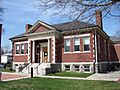
Ashland Public Library (2010)
-
Seal of Ashland, Massachusetts
-
Flag of Ashland, Massachusetts
-
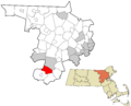
Location in Middlesex County in Massachusetts
