Sherborn, Massachusetts facts for kids
Quick facts for kids
Sherborn, Massachusetts
|
||
|---|---|---|

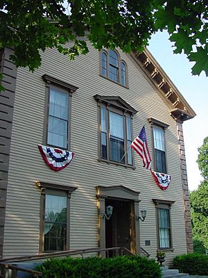
Sherborn Community Center
|
||
|
||

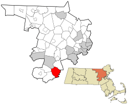
Location in Middlesex County in Massachusetts
|
||
| Country | United States | |
| State | Massachusetts | |
| County | Middlesex | |
| Settled | 1652 | |
| Incorporated | 1674 | |
| Government | ||
| • Type | Open town meeting | |
| Area | ||
| • Total | 16.2 sq mi (41.9 km2) | |
| • Land | 16.0 sq mi (41.3 km2) | |
| • Water | 0.2 sq mi (0.6 km2) | |
| Elevation | 175 ft (53 m) | |
| Population
(2020)
|
||
| • Total | 4,401 | |
| • Density | 275.1/sq mi (106.6/km2) | |
| Time zone | UTC−5 (Eastern) | |
| • Summer (DST) | UTC−4 (Eastern) | |
| ZIP Code |
01770
|
|
| Area code(s) | 508/774 | |
| FIPS code | 25-61380 | |
| GNIS feature ID | 0618233 | |
| Website | www.sherbornma.org | |
Sherborn is a town in Middlesex County, Massachusetts, United States. It is located in the MetroWest area, which is west of Boston. The town uses area code 508 and has the ZIP Code 01770. In 2020, about 4,401 people lived in Sherborn.
Sherborn shares its public school system with the town of Dover. Besides Dover, Sherborn is next to towns like Natick, Framingham, Ashland, Millis, Holliston, and Medfield.
Contents
About Sherborn's Location
Sherborn is located about 18 miles (29 km) southwest of Boston. The town covers a total area of 16.2 square miles (41.9 km²). Most of this area, about 16.0 square miles (41.3 km²), is land. The rest, about 0.2 square miles (0.6 km²), is water. A large part of the water area is in a place called Farm Pond.
Sherborn's Population Over Time
| Historical population | ||
|---|---|---|
| Year | Pop. | ±% |
| 1850 | 1,043 | — |
| 1860 | 1,129 | +8.2% |
| 1870 | 1,062 | −5.9% |
| 1880 | 1,401 | +31.9% |
| 1890 | 1,381 | −1.4% |
| 1900 | 1,483 | +7.4% |
| 1910 | 1,428 | −3.7% |
| 1920 | 1,558 | +9.1% |
| 1930 | 943 | −39.5% |
| 1940 | 1,022 | +8.4% |
| 1950 | 1,245 | +21.8% |
| 1960 | 1,806 | +45.1% |
| 1970 | 3,309 | +83.2% |
| 1980 | 4,049 | +22.4% |
| 1990 | 3,989 | −1.5% |
| 2000 | 4,200 | +5.3% |
| 2010 | 4,119 | −1.9% |
| 2020 | 4,401 | +6.8% |
| 2022* | 4,372 | −0.7% |
| * = population estimate. Source: United States Census records and Population Estimates Program data. |
||
In the year 2000, there were 4,200 people living in Sherborn. These people lived in 1,423 homes, and 1,222 of these were families. The town had about 263 people per square mile. Most of the people living in Sherborn were White (96.50%). A smaller number were Asian (2.40%), African American (0.38%), or Native American (0.05%). About 1.12% of the population was Hispanic or Latino.
Many homes (46.2%) had children under 18 living there. Most families (77.5%) were married couples. The average home had 2.95 people, and the average family had 3.22 people.
The population included people of all ages. About 31.9% were under 18 years old. About 30.7% were between 45 and 64 years old. The average age in Sherborn was 41 years.
Schools in Sherborn
Sherborn has a public elementary school called Pine Hill School. Students in middle school and high school from Sherborn usually go to schools in Dover, Massachusetts. These are the Dover-Sherborn Middle School and the Dover-Sherborn High School. There are also two preschools in Sherborn center: ECDC and Pine Hill Preschool.
Famous People from Sherborn
Many interesting people have connections to Sherborn:
- Eli Dershwitz is a world champion in fencing. He won the World Saber Championship in 2023.
- Stephanie Deshpande is a modern American painter. She is known for her portraits and story-telling paintings. She grew up in Sherborn.
- John Halamka is a doctor and a leader in technology.
- George Anthony Hill was a professor at Harvard. He wrote textbooks about physics and math.
- Dan Itse is an engineer and inventor. He serves in the New Hampshire House of Representatives. He grew up in Sherborn.
- Stan McDonald was a jazz clarinet player and recording artist. He lived in Sherborn.
- Mel Robbins is a TV host, life coach, and author. She is known for her motivational speaking.
- Jedediah Sanger was born in Sherborn in 1751. He lived there until after the American Revolutionary War.
- Chad Urmston is the lead singer of the band Dispatch. He went to Dover-Sherborn High School.
See also
 In Spanish: Sherborn (Massachusetts) para niños
 | Sharif Bey |
 | Hale Woodruff |
 | Richmond Barthé |
 | Purvis Young |


