Millis, Massachusetts facts for kids
Quick facts for kids
Millis, Massachusetts
|
||
|---|---|---|

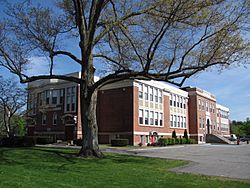
Veterans Memorial Building
|
||
|
||
| Motto(s):
In unitate vis (Latin "Strength in Unity")
|
||

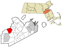
Location in Norfolk County in Massachusetts
|
||
| Country | ||
| State | ||
| County | Norfolk | |
| Settled | 1657 | |
| Incorporated | 1885 | |
| Government | ||
| • Type | Open town meeting | |
| Area | ||
| • Total | 31.8 km2 (12.3 sq mi) | |
| • Land | 31.5 km2 (12.2 sq mi) | |
| • Water | 0.3 km2 (0.1 sq mi) | |
| Elevation | 50 m (163 ft) | |
| Population
(2020)
|
||
| • Total | 8,460 | |
| • Density | 268.6/km2 (693.4/sq mi) | |
| Time zone | UTC-5 (Eastern) | |
| • Summer (DST) | UTC-4 (Eastern) | |
| ZIP code |
02054
|
|
| Area code(s) | 508 / 774 | |
| FIPS code | 25-41515 | |
| GNIS feature ID | 0618324 | |
Millis is a town in Norfolk County, Massachusetts. It's a part of the United States. In 2020, about 8,460 people lived there.
Millis is located about 19 miles (31 km) southwest of Boston. It shares borders with towns like Norfolk, Sherborn, and Medway. Two main roads, Route 109 and Route 115, pass through Millis.
Contents
History of Millis
Millis was first settled in 1657. It officially became its own town in 1885. Before that, Millis was part of Dedham. Then, in 1651, it became part of Medfield.
Later, in 1713, people from Medfield created a new town called Medway. This new town included what is now Millis. Lansing Millis, who helped found the town, worked hard to make Millis a separate town. It officially happened on February 24, 1885.
Railroads and Roads
Lansing Millis was known for his work with railroads. He built a strong rail system in Millis. This was very important because it helped Millis become independent from Medway. The railroad also helped the town grow economically. It connected Millis to bigger cities like Dedham, Boston, and Cambridge.
Today, the old railroad is called the Bay Colony Railroad. The tracks that used to go to Medway are gone. Now, Millis is the end of the line for this railroad. Some parts of the tracks in Millis are still used by the Bay Colony Railroad. This line connects with the MBTA Commuter Rail in Needham.
Another important part of Millis's history is the Hartford and Dedham Turnpike. This road was built in 1806 and is now known as Massachusetts Route 109. It connected Millis and other nearby towns directly to Dedham and Boston. Today, Route 109 is still a major road for towns in the Metrowest area to reach Boston.
Millis Wonderland
Millis was once home to the "Millis Wonderland." This was a huge display of Christmas lights and decorations. It was on a 40-acre (16-hectare) estate owned by Kevin Meehan. In 2004, TV host Al Roker visited Millis for a special report on The Today Show. After this, about 6,000 cars visited the "Millis Lights" every day during Christmas. The display closed for good after the 2014 holiday season.
Industrial History
Millis has a long history of different industries. It started with a small water-powered mill. Over time, many businesses opened, creating jobs and helping the town grow.
Some important industries included the Holbrook factories, which made bells and organs. The Clicquot Club and Herman Shoe Company were also very famous. Today, some of the main employers are Tresca Brothers Sand & Gravel and Roche Bros. Supermarket.
Herman Shoe Company
The Herman Shoe Company was a very important business in Millis. It made a lot of boots and other gear during the Spanish–American War. It also produced most of the boots worn by soldiers during World War II. The company is no longer in business. Its old factory was taken down in March 2020.
Clicquot Club
Clicquot Club was started by Henry Millis. He used money from his father, Lansing Millis, who founded the town. This company was the first in the U.S. to sell ginger ale. It was located on Main Street and gave its name to the village of Clicquot in Millis.
The ginger ale was made using local Millis ginger. Later, Clicquot Club made other sodas and was the first company in the country to sell drinks in cans. The company had over 100 factories across the U.S. and sold its drinks worldwide. However, sales dropped in the 1960s, and the company was eventually bought by other companies.
Causeway Street and the Brickyards
The area around Causeway Street was once a big industrial center for Millis. Clay and sand were dug up here. The clay was used to make bricks for many large buildings nearby and further away. Today, the old clay pits look like small ponds. One large pit is now a body of water called Heather's Pond. These old pits are now home to many animals and are protected. The sand from these pits was even used to help build a runway at Logan International Airport.
Wealthy families owned the large brickyards on Causeway Street. One of these estates later belonged to Christian Herter. He was a former Governor of Massachusetts and a United States Secretary of State.
Notable Sites
One important place in Millis is Richardson's Tavern, built around 1720. It is said that George Washington had lunch there in 1775 on his way to Cambridge. It is also rumored that Nathan Hale and the Marquis de Lafayette visited the tavern.
Millis's cemetery, Prospect Hill Cemetery, is where Christian Herter is buried. He was the U.S. Secretary of State under President Dwight D. Eisenhower. Secretary Herter lived on a large farm on Causeway Street in Millis. Prospect Hill Cemetery is listed on the National Historic Register.
King Philip's War History
Millis's history is also connected to King Philip's War (1675-1676). On February 21, 1676, Native Americans attacked Medfield, destroying half the town. After this attack, the Native Americans, led by King Philip (Metacom), came to Millis and held a large feast. This spot is marked by "The King Philip Trees," which are very old trees protected by the Millis Historical Society.
The next day, February 22, the Native American forces attacked the Fayerbanke Palisades at Boggestowe Farms, which are in Millis today. This attack was stopped. Another attack on May 6 was also repelled.
Geography of Millis
Millis has many protected lands. These areas help keep the environment safe and limit new buildings. The town also has several wells and large farms.
The Charles River flows through Millis. There are also smaller streams and brooks, like Bogastow Brook. Bogastow Brook is named after the Native American tribe that used to live in the area. It starts in East Holliston and flows through Millis, ending in South End Pond.
Millis is also home to the Great Black Swamp. This large swamp covers hundreds of acres. It helped separate Millis from its neighbor, Medway, when Millis became its own town in 1885.
The town covers about 12.3 square miles (31.8 km2). Most of this is land (12.2 sq mi or 31.5 km2), and a small part is water (0.1 sq mi or 0.3 km2).
Population and People
| Historical population | ||
|---|---|---|
| Year | Pop. | ±% |
| 1890 | 786 | — |
| 1900 | 1,053 | +34.0% |
| 1910 | 1,399 | +32.9% |
| 1920 | 1,485 | +6.1% |
| 1930 | 1,738 | +17.0% |
| 1940 | 2,278 | +31.1% |
| 1950 | 2,551 | +12.0% |
| 1960 | 4,374 | +71.5% |
| 1970 | 5,686 | +30.0% |
| 1980 | 6,908 | +21.5% |
| 1990 | 7,613 | +10.2% |
| 2000 | 7,902 | +3.8% |
| 2010 | 7,891 | −0.1% |
| 2020 | 8,460 | +7.2% |
| 2023* | 9,018 | +6.6% |
| * = population estimate. Source: United States Census records and Population Estimates Program data. | ||
In 2020, there were 8,472 people living in Millis. Most residents (92.3%) were White. About 1.8% were African American, and 1.7% were Asian. About 2.5% of the population was Hispanic or Latino.
About 11.1% of the people in Millis were born outside the U.S. Also, 14.9% of people over 5 years old speak a language other than English at home.
There were 3,110 households in 2020. The average household had 2.65 people. Most homes (82.7%) were owned by the people living in them. About 21.4% of the population was 18 years old or younger, and 19.6% were 65 or older.
The average household income in Millis was $114,255. About 1.2% of the population lived in poverty. Most adults (96.5%) had a high school diploma. Nearly half (48.4%) of adults over 25 had a bachelor's degree or higher.
Education in Millis
The Millis school system is led by Superintendent Robert Mullaney. The district has three schools: Clyde F. Brown Elementary School and Millis Middle/High School. About 1,175 students attend these schools.
In 2007, Millis was given the Blue Ribbon School Of Excellence award by the U.S. Government. Millis High School has also been recognized as a top high school by U.S. News & World Report. In 2010, it was ranked among the top 3% of high schools in the United States. As of 2021, Millis High School was ranked #74 in Massachusetts by U.S. News & World Report.
The Millis Public Library is the only library in town. It is part of the Minuteman Library Network.
Notable People from Millis
- Matthew Boldy - An NHL Hockey player for the Minnesota Wild.
- Haskell Curry - A famous mathematician and logician. He was a pioneer in functional programming.
- Misha Defonseca (Monique De Wael) - An author known for her book Misha: A Memoire of the Holocaust Years. She later said that the story in her book was not true.
- Christian Herter - He was the U.S. Secretary of State under President Dwight D. Eisenhower.
- John Kerry - A former U.S. Senator. He lived in Millis until he was seven years old.
- John St. Cyr - A politician, lawyer, and judge.
See also
 In Spanish: Millis (Massachusetts) para niños
 | James Van Der Zee |
 | Alma Thomas |
 | Ellis Wilson |
 | Margaret Taylor-Burroughs |


