Summerfield Township, Clare County, Michigan facts for kids
Quick facts for kids
Summerfield Township, Michigan
|
|
|---|---|

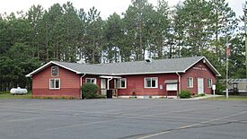
Summerfield Township Hall
|
|

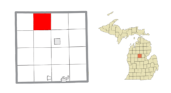
Location within Clare County
|
|
| Country | United States |
| State | Michigan |
| County | Clare |
| Established | 1873 |
| Area | |
| • Total | 35.90 sq mi (92.98 km2) |
| • Land | 35.20 sq mi (91.17 km2) |
| • Water | 0.70 sq mi (1.81 km2) |
| Elevation | 1,096 ft (334 m) |
| Population
(2010)
|
|
| • Total | 456 |
| • Density | 13.0/sq mi (5.0/km2) |
| Time zone | UTC-5 (Eastern (EST)) |
| • Summer (DST) | UTC-4 (EDT) |
| ZIP code(s) | |
| Area code(s) | 989 |
| FIPS code | 26-77120 |
| GNIS feature ID | 1627133 |
Summerfield Township is a small community in Clare County, Michigan. It's a type of local government area called a civil township. In 2020, about 459 people lived here.
Contents
Communities in Summerfield Township
Summerfield Township is home to a few smaller communities. These are often called "unincorporated communities" because they don't have their own separate local government like a city or town.
Buck Trails
Buck Trails is a small community in the southeastern part of Summerfield Township. You can find its location using these coordinates: 44°06′05″N 84°51′28″W / 44.1014068°N 84.8578051°W.
Leota
Leota is another community found in the northern part of the township, right by the Muskegon River. It is about 12 miles (19 km) north of Harrison. A long time ago, in 1899, there was even a post office here, but it's not there anymore. Its coordinates are 44°08′22″N 84°53′22″W / 44.13944°N 84.88944°W.
Rainbow Bend
Rainbow Bend is a community located within the township, also along the Muskegon River. Its coordinates are 44°07′43″N 84°55′18″W / 44.1286279°N 84.9216972°W.
Geography and Nature
Summerfield Township covers an area of about 35.90 square miles (92.98 square kilometers). Most of this area, about 35.20 square miles (91.17 square kilometers), is land. The rest, about 0.70 square miles (1.81 square kilometers), is water.
The important Muskegon River flows right through the township. This river is a big part of the local landscape and nature.
People of Summerfield Township
In 2000, there were 453 people living in Summerfield Township. The township had about 217 households. Most of the people living here were White.
The average age of people in the township was 49 years old. About 15.5% of the population was under 18 years old.
Education
Students in Summerfield Township attend schools in the Harrison Community Schools district. These schools are located to the southeast in the city of Harrison.
See also
 In Spanish: Municipio de Summerfield (condado de Clare) para niños


