Sumneytown, Pennsylvania facts for kids
Quick facts for kids
Sumneytown, Pennsylvania
|
|
|---|---|
|
Unincorporated community
|
|
 |
|
| Country | United States |
| State | Pennsylvania |
| County | Montgomery |
| Township | Marlborough |
| Elevation | 203 ft (62 m) |
| Time zone | UTC-5 (Eastern (EST)) |
| • Summer (DST) | UTC-4 (EDT) |
| ZIP code |
18084
|
| Area code(s) | 215, 267 and 445 |
| GNIS feature ID | 1189058 |
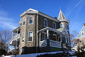
Sumneytown is a small, unincorporated community located in Marlborough Township, Montgomery County, Pennsylvania, United States. An unincorporated community is a place where people live, but it does not have its own local government like a city or a borough. You can find Sumneytown right on Route 63.
Contents
History of Sumneytown
How Sumneytown Got Its Name
This community was named after an early settler named Issac Sumney. He was an important person in the area's history. In 1762, Issac Sumney opened a famous inn called the Red Lion in the village.
Old Roads and Travel
A very old road, known as the Kings Highway, used to pass right through Sumneytown. Today, the part of this road that goes north from Sumneytown to the Lehigh County line is called Geryville Pike.
In 1848, a new road was built. It was called the Sumneytown and Spring House Turnpike. This turnpike connected Sumneytown to Marlborough. It made it easier for people to travel. Wealthy families from Philadelphia started visiting Sumneytown for vacations. This brought more visitors and business to the area. Today, parts of this old turnpike are still used as Route 63.
Mail Services
Sumneytown has its own post office. It uses the zip code 18084. However, some people who live nearby get their mail from the Green Lane post office, which has the zip code 18054.
Geography and Climate
Natural Boundaries
The Unami Creek is a natural border for Sumneytown. It runs along the southeastern side of the community. This creek separates Sumneytown from Salford and Upper Salford Townships. The Unami Creek then flows southwest until it joins the Perkiomen Creek.
Local Roads
Route 63 begins just northwest of Sumneytown in a place called Green Lane. From there, it travels southeast towards the Lansdale and North Wales areas. This part of the road is known as Sumneytown Pike.
Sumneytown's Climate
Sumneytown has a type of weather called a hot-summer humid continental climate. This means it has warm, humid summers and cold winters. The average temperature in January is about 30.4 degrees Fahrenheit. In July, the average temperature goes up to about 75.1 degrees Fahrenheit. The area is in hardiness zone 7a, which helps gardeners know what plants can grow there.
 |
Green Lane | Marlborough Township | Finland |  |
| Perkiomenville | Salford Township | |||
| Upper Frederick Township | Hendricks | Woxall, Bergey |


