Swanson, New Zealand facts for kids
Quick facts for kids
Swanson
|
|
|---|---|
|
Suburb
|
|

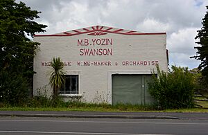
Wholesale wine-Maker in Swanson
|
|
| Country | New Zealand |
| Local authority | Auckland |
| Electoral ward | Waitākere ward |
| Local board |
|
| Area | |
| • Land | 209 ha (516 acre) |
| Population
(June 2023)
|
|
| • Total | 3,410 |
| Train station(s) | Swanson railway station |
|
|
||
Swanson is a suburb located in West Auckland, New Zealand. It lies west of Henderson and is surrounded by the Waitākere Ranges. In the 1880s, Swanson grew as a service hub for the kauri logging and gumdigging industries, thanks to the new train line.
The town became a rural center and an early holiday spot for people from Auckland. They often visited Redwood Park, which was located along the Swanson Stream. Later, in the 1940s, the park was used to train soldiers during World War II. In 1970, it hosted Redwood 70, New Zealand's first big modern music festival.
Contents
Swanson's Natural Environment
The Swanson area is mainly a valley located northeast of the Waitākere Ranges. It is a key area where water collects for the Swanson Stream. Before people settled here, Swanson was covered in warm lowland forests. These forests had many large trees like kauri, rimu, rātā, kahikatea, and rewarewa.
The areas next to the Swanson Stream were often flooded. This made them perfect for kahikatea and tōtara trees to grow.
Swanson's Past: A Journey Through Time
Early Days and Māori Heritage
The Swanson area is the traditional home, or rohe, of Te Kawerau ā Maki. This Tāmaki Māori tribe has lived in the West Auckland and Waitākere Ranges for a long time. An old fortified village, called a pā, named Pukearuhe (meaning "Bracken Fern Hill") was found in the hills above Swanson.
The Swanson area was part of a walking path between Te Henga / Bethells Beach and the Wai Huruhuru Manawa tidal inlet. This inlet is part of the Te Wai-o-Pareira / Henderson Creek. The valley of the Swanson Stream was known as Waiwhauwhaupaku. This name comes from the Pseudopanax arboreus (five-finger tree) that grew thickly there.
Southern Swanson was called Waimoko, named after the skinks and geckos found in the area. Te Kawerau ā Maki faced difficult times in the late 1700s and early 1800s. They suffered from illnesses and wars in the 1820s. When the tribe returned in the 1830s, they focused their lives at Te Henga / Bethells Beach.
In the 1850s, much of West Auckland was sold to European settlers. This happened without the main leaders of Te Kawerau ā Maki knowing or agreeing.
Founding the Town and Kauri Industry
A pioneer named William Swanson settled in the area in 1852. He began logging kauri trees along the Swanson Stream and other waterways. By the 1870s, he became a strong critic of how kauri trees were being logged.
The town of Swanson was officially started in the mid-1880s. Many of the first people to live there received land cheaply from the government. This was part of a plan to develop the area. In 1881, the Swanson railway station opened, connecting the area to the city of Auckland.
The railway station became a busy hub for the kauri logging trade from the northern Waitākere Ranges. The town grew as a service center for people working in logging and kauri gum digging. Many early residents started farms and orchards. They also earned extra money by digging for kauri gum.
In the late 1800s, Croatian immigrants (then called Dalmatian) also worked the land in Swanson. They dug for kauri gum in a more organized way than before.
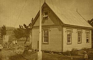
The Swanson School opened on June 18, 1888, to serve the community. Before this, children had to travel to Woodhill for school. The school was very important to the community in the late 1800s. It was a place for religious services, concerts, and meetings.
Swanson as a Tourist Spot and Training Camp
From the late 1880s, Swanson became a popular place for picnics and day trips from Auckland. People came to see the Waitākere Falls and Redwood Park along the Swanson River. Later, due to damaged paths, tourists preferred to visit the falls through Henderson.
In 1905, a decision was made to build the Waitākere Dam at the falls. This was to provide better drinking water for Auckland city. Swanson town provided many workers for this project. By 1907, a tramline was built between the dam site and the Swanson railway station. The dam was finished in 1910, and a water filter plant was built in Swanson in the 1920s.
Redwood Park was a popular picnic spot in the 1890s and early 1900s. On New Year's Day 1900, between 1,500 and 2,000 picnickers visited Swanson. In 1921, Arney Robertson bought the park and called it the Swanson Park and Recreation Ground. It became Redwood Park in 1934 when 3,000 redwood trees were planted.
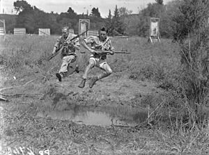
In early 1940, the New Zealand Army took over Redwood Park. They used it as a training camp for soldiers during World War II. Later, the Royal New Zealand Air Force used it for bush warfare training. The army camp became a big part of the Swanson community during the war. It hosted regular dances and events. The camp closed in August 1945. After that, it became one of New Zealand's largest inland motor camps.
Local winemaker Milan Babić Yozin started growing wine in Swanson in 1942. He had already set up many orchards there in the 1930s.
Swanson's Growth and Modern Times
Swanson's population grew a lot between the 1920s and 1980s, from 500 to almost 2,000 people. In 1970, Redwood Park in Swanson hosted Redwood 70. This was New Zealand's first major music festival. It featured Robin Gibb from the Bee Gees. Over 9,000 people attended the two-day concert. The next year, Redwood Park was sold and turned into a golf course and country club.
In 1984, the Waitemata City council opened a landfill north of Swanson. This caused problems for residents with rubbish blowing around and gas smells. Five years later, the Waitakere City council suggested keeping the landfill open for 50 more years. This led to a big protest movement in Swanson. The Swanson Balefill Action Group was formed.
The group successfully convinced the council, and the Kay Road Balefill was officially closed in November 1996. Crystal Mountain Mine Museum, a special museum, has been open in Swanson since 2000.
Swanson's People
Swanson covers about 2.09 square kilometers. As of 2023, it had an estimated population of 3,696 people. This means there are about 1,768 people per square kilometer.
Swanson's population has grown quite a bit. In 2013, there were 1,653 people. By 2018, it grew to 2,241. In the 2023 census, the population reached 3,696. This is a big increase of 1,455 people since 2018.
The median age in Swanson is about 33.3 years. About 21.9% of the people are under 15 years old. Another 21.2% are aged 15 to 29. Most people, about 49.8%, are between 30 and 64 years old. About 7.1% of the population is 65 or older.
People in Swanson come from many different backgrounds. About 48.5% are European (Pākehā). There are also 15.4% Māori, 14.1% Pasifika, and 34.6% Asian. English is spoken by most people (92.6%). Other languages like Māori (3.2%) and Samoan (3.6%) are also spoken. About 40.9% of the people in Swanson were born outside New Zealand.
Many people in Swanson have completed higher education. About 25.4% of those aged 15 and over have a bachelor's degree or higher. Another 45.5% have a post-high school certificate or diploma. Most adults (60.7%) are employed full-time.
Getting Around Swanson
The Swanson railway station is located on the North Auckland Line. This station is the end point for the Western Line train services for passengers. It is the westernmost and northernmost part of the electrified rail network.


